March Kicks Off Our Spring Campaign- Donate Now to Support Forecasting

Forecast for the Uintas Area Mountains

Craig Gordon
Issued by Craig Gordon on
Tuesday morning, January 26, 2021
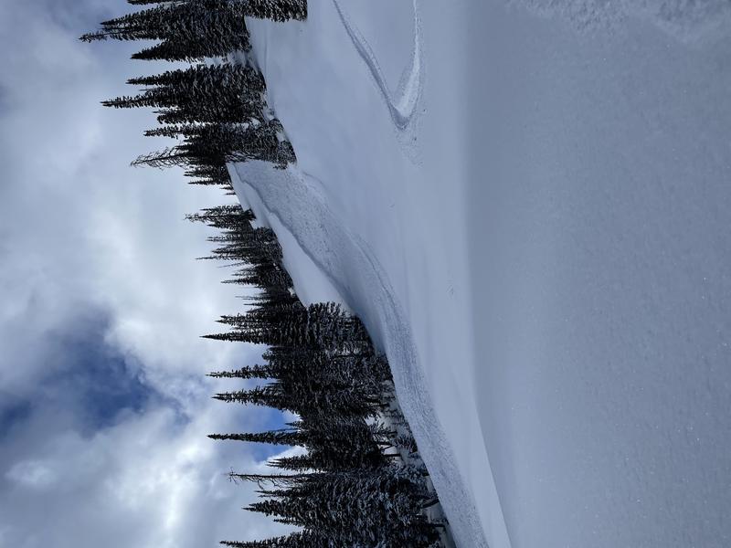
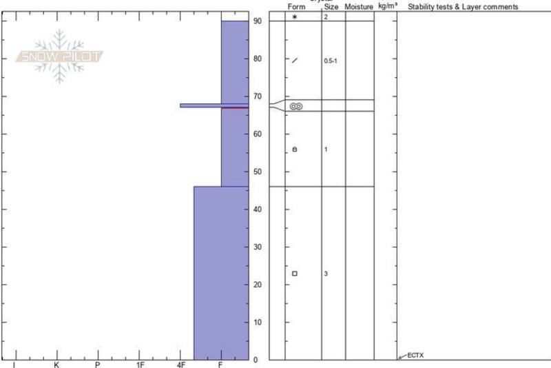
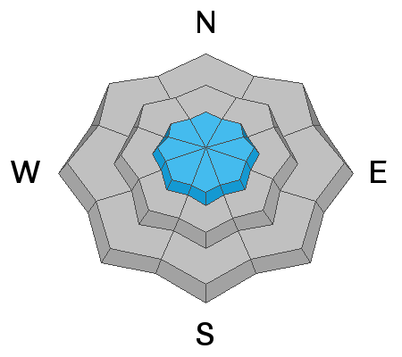
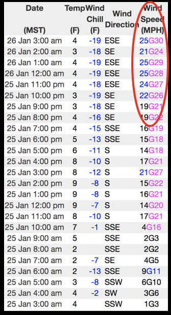
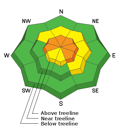
In the wind zone at and above treeline, CONSIDERABLE avalanche danger is found on steep slopes and HUMAN TRIGGERED AVALANCHES ARE LIKELY, especially in terrain facing the north half of the compass. Remember- our recent storm stacked up on a snowpack that resembles a house of cards and now the winds are blowing, whipping up cohesive slabs that'll break deeper and wider than you might expect. You don't need to be on steep slopes in order to trigger avalanches, you just need connected to them. Avoid being on, near, or underneath steep terrain.
The avalanche danger is MODERATE at mid elevations and human triggered avalanches are POSSIBLE on steep, shady slopes.

I hear you're looking for LOW avalanche danger. Well then, here's your exit strategy for safer riding and avalanche avoidance. The Uinta mountains have plenty of low angle, rolly-polly terrain options (slopes less than 30 degrees in steepness). Think, big open meadows with no steep slopes above or adjacent to where you're riding.
Low
Moderate
Considerable
High
Extreme
Learn how to read the forecast here
Weather and Snow
Nowcast-
As a robust storm moves away from southern Utah, high clouds streamed into our region late yesterday and thickened overnight. East and southeast winds ramped up along the high ridges right around 10:00 last night and continue blowing steadily in the mid 20's early this morning. A few stray snow flurries fall and current temperatures register in the single digits. Last Friday's storm vastly improved riding and turning conditions, but it's still quite thin and the range looks like we're about a month behind, particularly at lower elevations. In any case, the storm was a much needed thick coat of white paint and average snow depths now hover just over 3'.
Forecast-
A storm system over southern Utah gradually shifts east near the Utah/Arizona border through the day. As such, look for mostly cloudy skies with temperatures barely cracking into the upper teens. The big news is the southerly winds which ramp up as the day progresses, blowing into the 30's and 40's by days end.
Futurecast-
It looks like an active pattern keeps unsettled weather coming our way this week, with a couple inches of snow here and there. Another storm slated for late in the week dives to our south, but we might be able to squeeze a few inches of snow out of it. A break Sunday and Monday with another storm on tap for early next week.

Looking for real-time temps, snow, or wind?
Click here and then on the "western Uinta" tab for western Uinta specific, weather station network.
Recent Avalanches
The slide in the image above on a steep, shady slope near Hoyt Peak, was triggered Sunday from about 50' away as a rider climbed an adjacent slope. Not particularly big, but large enough to boss you around. The fact that you can trigger avalanches from a distance is a huge red flag.

Check here for additional trip reports and avalanche observations.
Ad
Avalanche Problem #1
Persistent Weak Layer
Type
Location
Likelihood
Size
Description
The snowpack is adjusting to last Friday's storm and it's slowly becoming more comfortable in its own skin. However, we need to remember, our Persistent Weak Layer, buried in the mid portion of the snowpack is in its teenage years and it doesn't take much effort to get it riled up. In fact, on my field day Sunday, I experienced sudden collapses of the snowpack along with muted whoomphing sounds... all indicators of a weak, rotten snowpack with a dense layer of snow on top. So, while the surface snow may feel good to go, we need to think about not only the snow we're riding in, but also the snow we're riding on. And remember- any slide triggered will break several feet deep, and a couple hundred feet wide, failing on one of the many persistent weak layers of faceted snow in the snowpack (see the photo below).
There are three things that make the setup deceptively tricky:
  1. There's not an abundance of in yer face clues like natural avalanches, but many steep slopes wait for a trigger like us to roll along and knock the legs out from underneath.
  2. You won't have to be on steep terrain in order to trigger a slide. Just being near or under a steep slope is enough to tip the balance. And previous tracks on the slope shouldn't be your barometer of slope stability. It could easily be the 3rd or 4th or 10th person that triggers an avalanche.
  3. Several wind events, including last night, created dense, cohesive slabs that may be hard to detect. Older slabs are now buried in our pack and are harder to trigger until you hit the right spot on a slope, which of course, we can't see. The resulting avalanche is a thick, hard slab that easily ruins your day or perhaps your season.
Image below clearly shows a junk show. If you wouldn't build your house on a foundation like this... don't bet your life on it.
Video describing how you can trigger avalanches from below.
Avalanche Problem #2
Wind Drifted Snow
Type
Location
Likelihood
Size
Description
The image above illustrates a 24 hour data dump from Lofty Lake Peak, elevation 11,186', clearly showing a bump in the sustained ridgetop winds overnight into early this morning.
We know the wind always blows in the Uinta's, as a matter of fact... it's where wind was invented! With that in mind, a bump in ridgetop winds overnight will create drifts, sensitive to our additional weight. Found mostly on the leeward side of upper elevation ridges, today you'll also want to be on the lookout for fresh drifts around terrain features like chutes and gullies. Remember- a fresh wind drift may break deeper and wider than you might expect, especially as it crashes down on a slope below. Easy to manage and even easier to avoid... simply lose some elevation and you lose the problem.
Additional Information
I will update this forecast by 7:00 AM tomorrow, Wednesday January 27th.
Your observations are import, so please let me know what you're seeing... click HERE and contribute to this amazing community based program
General Announcements
If you see or trigger an avalanche or just wanna let me know what you're seeing you can reach me directly at 801-231-2170 or [email protected]
This forecast is from the U.S.D.A. Forest Service, which is solely responsible for its content. This forecast describes general avalanche conditions and local variations always occur.