Join us at our 2nd Annual Blizzard Ball

Forecast for the Skyline Area Mountains

Dave Kelly
Issued by Dave Kelly on
Monday morning, January 27, 2025
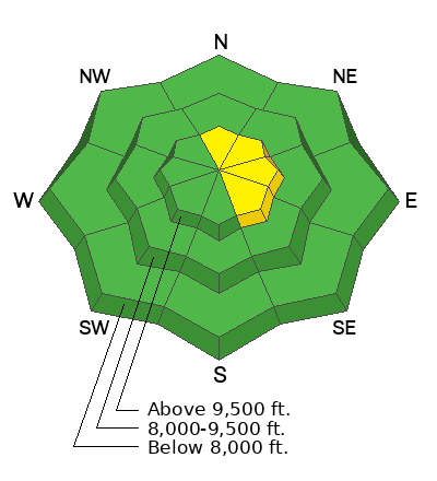
The avalanche danger is MODERATE on all mid and upper elevation slopes facing west through north and east where it will be possible to trigger an avalanche failing on weak faceted snow 2'-4' deep. All other slopes have a LOW avalanche danger.
If you're sinking to the ground when you step off your sled or boards then avoid slopes in that zone greater than 30° in steepness.
Low
Moderate
Considerable
High
Extreme
Learn how to read the forecast here
Special Announcements
URGENT!! Battery replacement required for anyone who received batteries from one of our participating "Batteries for Beacons" shops. We've found that the Duracell Procell AAA batteries are too short in length and may not make contact in avalanche beacons causing them to malfunction. DETAILS HERE
Weather and Snow
Under partly cloudy skies, trailhead temperatures are in the low single digits °F and the 10,000' weather stations are in the mid-teens °F. Winds at the lowest weather stations are blowing lightly and the highest weather stations are blowing from the east in the mid-teen's MPH.
Today, we should see mostly clear skies with high clouds and temperatures between 28-34°F. Winds will blow lightly at the lower elevations and from the east at the higher elevations 15 gusting to 20 MPH. East winds are hard to forecast and I wouldn't be surprised if we saw higher gusts from the east and northeast late in the afternoon.
This most recent storm didn't amount to much in most of the forecast region. We saw just under 1" of new snow at the Huntington Canyon Summit and no new snow in Spring City Canyon. The new snow did help improve the surface conditions out of the wind zone. Magerl reported a soft breakable crust (photo below) on the surface, but it was soft enough to not interfere with turns. In the wind zone we were still hitting old hard wind drifts and sastrugi (which is a fun word for wind hammered snow surface).
Recent Avalanches
Yesterday, there were no reports of avalanches. Check out all observations HERE.
Ad
Avalanche Problem #1
Persistent Weak Layer
Type
Location
Likelihood
Size
Description
The likelihood of triggering a persistent weak layer avalanche has gone down, however the consequences remain the same. It may not take much additional wind or new snow to tip the scales and it will be possible for a human to trigger an avalanche failing 2'-4' deep. This will be more likely in thin, rocky, locations on steep terrain (greater than 30°) facing west-north-east at mid and upper elevations. A couple of days ago there were reports of whumpfing and collapsing on lower angle slopes near Electric Lake. This is a sign that the weak faceted snow could still avalanche in steeper terrain and if you hear or feel collapsing or whumpfing find lower angle (less than 30°) slopes to travel on or under.
General Announcements
This forecast is from the U.S.D.A. Forest Service, which is solely responsible for its content. This forecast describes general avalanche conditions and local variations always occur.