Forecast for the Skyline Area Mountains

Brett Kobernik
Issued by Brett Kobernik on
Tuesday morning, April 8, 2025
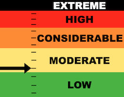
Most of the terrain on the Skyline has a LOW avalanche danger.
Overall, the threat of avalanches is not that great but there are some things to keep in mind as you travel around. Be sure to read about the different avalanche problems below. Most of the issues will be very manageable if you're paying attention.
Low
Moderate
Considerable
High
Extreme
Learn how to read the forecast here
Weather and Snow
Current Conditions: Temperatures on Monday got into the upper 40s and only cooled into the upper 30s overnight. Wind picked up speed slightly along the highest terrain but is generally still light in most locations. The snow surface is typical for the spring. Despite warm overnight temperatures, you'll still find stiff frozen snow this morning that will become wet and soft as daytime heating occurs.
Mountain Weather: We'll see clouds today with high temperatures near 50˚F. Wind from the west will slow during the day. Skies clear out more on Wednesday with a continued warming trend through Saturday.
Recent Avalanches
There has been no significant avalanche activity for over two weeks. You can always check into all the avalanches that we hear about HERE.
Ad
Avalanche Problem #1
Cornice
Type
Location
Likelihood
Size
Description
The most likely type of avalanche activity we'll see this week is cornice falls. Large cornices that have been forming all winter are starting to weaken from the warm temperatures. They will be breaking off in random locations through the week. This is a simple problem to manage:
  • Don't travel on top of cornices.
  • Don't travel underneath cornices.
Avalanche Problem #2
Wet Snow
Type
Location
Likelihood
Size
Description
The next thing to keep in mind is wet snow avalanche activity. This threat increases during the heat of the day when the snow gets wet. Point release loose wet snow avalanches are what you might see. These can fan out and get wider as they descend slopes. Most of these will be natural but you can initiate them by disturbing the snow also. These need a very steep slope to be a threat. This problem is also simple to manage:
  • Avoid being on or below very steep slopes when the snow becomes wet, saturated, sloppy and punchy.
Avalanche Problem #3
Persistent Weak Layer
Type
Location
Likelihood
Size
Description
The last thing to keep in mind is the old persistent weak layers of sugary faceted snow that formed much earlier in the season. These layers caused the most dangerous avalanches in March. Since then, the snowpack has settled and gained strength. Generally, by this time of the winter it becomes very unlikely to see slab avalanches breaking into these old weak layers. However, it was a very unusual and prolonged season with these weak layers and I have a hard time trusting them still. In the unlikely event that a person triggers one of these, it would be on high elevation very steep slopes that face north, northeast and east.
One more note on these old weak layers. There is a good chance that these will become active again during the spring warm up. Eventually, water will start percolating through the snowpack down to those layers and they will weaken. At this point, natural avalanches could occur. I don't think things will get to that point this week, but maybe. Generally, this happens later in the spring and usually no one is out recreating in the mountains when these avalanches start to shed.
General Announcements
This forecast is from the U.S.D.A. Forest Service, which is solely responsible for its content. This forecast describes general avalanche conditions and local variations always occur.