Forecast for the Skyline Area Mountains

Brett Kobernik
Issued by Brett Kobernik for
Saturday, April 6, 2019
The avalanche danger will again be mostly LOW today but may rise to MODERATE with daytime heating. This will be more pronounced in the lower and mid elevations where the snowpack will be more wet. Avoid steep slopes when they become overly wet, sloppy and punchy.
Low
Moderate
Considerable
High
Extreme
Learn how to read the forecast here
Weather and Snow
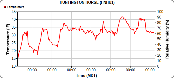
The most important thing concerning weather is that we've had a couple of nights of very mild temperatures with overnight lows at or above freezing. When this happens it can lead to increased wet snow avalanche activity. Below is a chart of temperatures over the last 7 days from the weather station at The Big Drift with the most recent data on the right side of the chart. The warming trend is obvious:
We have a very minor weather disturbance moving through this morning that could bring a snow shower or two. It's possible that skies will start to clear out this afternoon. We'll see high temperatures in the mountains in the upper 30s.
Sunday and Monday look clear and warm. Another storm is shaping up for late Tuesday into Wednesday which looks like it should bring a good shot of snow to our area.
Ad
Avalanche Problem #1
Wet Snow
Type
Location
Likelihood
Size
Description
You always want to pay attention to how wet the snowpack gets during the daytime heating in the Spring. When it gets excessively damp to the point where your boots are punching deep into the snowpack or when you feel your machine or skis punching through, it's time to start avoiding steep slopes. One indicator of potential wet snow avalanches is when we see warm overnight temperatures for a number of days in a row. I've noticed "glide cracks" starting to open up which is also an indicator that our snowpack is in it's Springtime transition. These glide cracks can turn into avalanches so if you come across them, don't linger underneath them. They are unpredictable.
Additional Information
This forecast is from the U.S. Forest Service, which is solely responsible for its content. This forecast describes general avalanche conditions and local variations always occur.