Forecast for the Skyline Area Mountains

Brett Kobernik
Issued by Brett Kobernik for
Saturday, March 30, 2024
The overall avalanche danger is mostly LOW on the Skyline today.
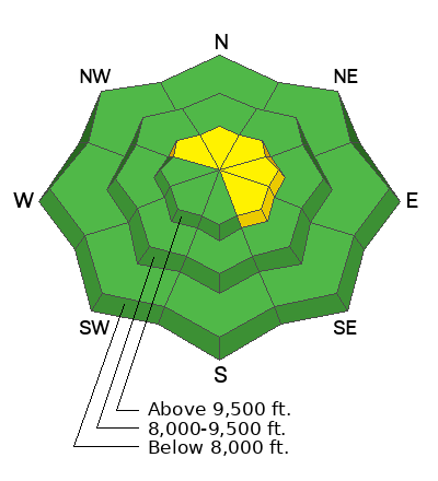
There is a MODERATE avalanche danger on steep upper elevation slopes that face northwest through southeast where there are recent deposits of wind drifted snow.
Low
Moderate
Considerable
High
Extreme
Learn how to read the forecast here
Weather and Snow
Current Conditions: There was a period of clearing mid day Friday that I was not expecting. Sun and warm temperatures instantly took a toll on the new snow making it wet and mushy. Temperatures got into the low 30s. A trace to a few inches of snow fell overnight. Wind from the southwest picked up speed into the moderate category along the highest terrain. Overnight temperatures were in the mid 20s.
Mountain Weather: This storm has been a little tricky to forecast. I'm expecting snow starting mid day with minor accumulations through the afternoon. Temperatures will get into the low to mid 30s. Wind from the southwest will be light to moderate in speed. It'll probably feel a little breezy along the highest terrain. Periods of snow continue tonight and we might see 3 to 6 inches total by Sunday morning. Snow continues Sunday into Monday with another 3 to 6 inches possible. The flow is from the southwest and it looks like the northern end of the Skyline will be favored for snow totals.
Ad
Avalanche Problem #1
Wind Drifted Snow
Type
Location
Likelihood
Size
Description
You're only real concern today is triggering a fresh wind drift or wind slab. Wind from the southwest picked up just enough to drift a little snow over the last 24 hours. I'm not expecting this to be a huge issue but it's worth a mention. Steep upper elevation slopes that face northwest through southeast are the most likely places to trigger a pocket. Simply avoid steep terrain where there are recent deposits of wind drifted snow and you'll stay safe today.
General Announcements
This forecast is from the U.S.D.A. Forest Service, which is solely responsible for its content. This forecast describes general avalanche conditions and local variations always occur.