UDOT PLANNED AVALANCHE CLOSURES!!

Forecast for the Skyline Area Mountains

Brett Kobernik
Issued by Brett Kobernik on
Thursday morning, March 14, 2024
The overall avalanche danger rating for the Skyline is MODERATE but may increase to CONSIDERABLE this afternoon.
Fresh drifts and wind slabs may form later in the day as the wind from the east picks up speed.
With this odd east wind direction, we'll probably see drifts and slabs form in areas that are out of the ordinary.
West facing slopes may become more dangerous than east facing slopes which is usually not the case. Act accordingly.
Low
Moderate
Considerable
High
Extreme
Learn how to read the forecast here
Weather and Snow
Current Conditions: Another 4 inches of snow accumulated in the last 24 hours bringing totals up to around 10" or a bit more since Tuesday. The central and southern Skyline did better than the northern area around Fairview Canyon which picked up only about 4 to 6 inches total. Riding conditions are good. The new snow contained some graupel (hail) which gave it a creamy feel when riding on it. Wind has been generally light from the west but is not starting to switch around and come from the east. Temperatures dropped into the single digits overnight.
Mountain Weather: The flow is starting to switch around and come from the east. We'll see the wind pick up speed by mid day. It looks like the northern end of the Skyline will see stronger speeds than the southern end. It's going to be cloudy. Temperatures will get into the mid 20s. We could see some snow this afternoon but it probably won't accumulate all that much today. I'm skeptical still but there is good agreement among five different weather models which insist that we'll see a pretty decent shot of snow from this storm that will last into Saturday. They advertise 1 to 2 inches of water which translates to 10 to 20 inches of snow. The flow stays from the east through the weekend. The way I could see this shaking out is that the central and southern Skyline receive the most snow especially on the east side of the range. We probably won't see much happening here in Sanpete Valley.
Ad
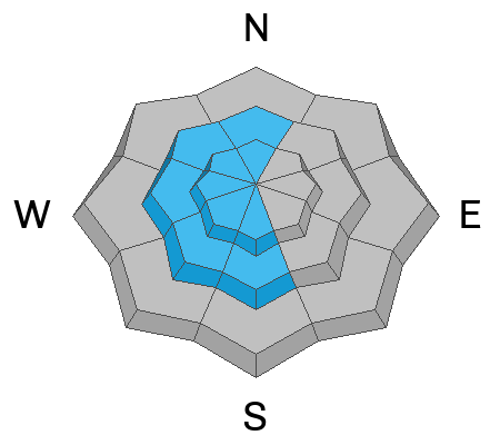
Avalanche Problem #1
Wind Drifted Snow
Type
Location
Likelihood
Size
Description
I found the new snow by itself to be stable on Wednesday. My fieldwork was pretty limited though because of snowfall and poor visibility making for difficult travel conditions. My sense is that we won't see much avalanche danger until the wind starts blowing and drifting snow. We may start to see this later in the day today. By noon we could see some stronger wind from the northeast especially on the north end of the Skyline. If this is the case, you'll want to start watching out for fresh drifts. Pay extra attention as this is an odd wind direction for us and we'll probably see odd loading patterns. In other words, you might trigger a drift or wind slab in areas you usually wouldn't and you're not expecting to.
General Announcements
This forecast is from the U.S.D.A. Forest Service, which is solely responsible for its content. This forecast describes general avalanche conditions and local variations always occur.