UDOT PLANNED AVALANCHE CLOSURES!!

Forecast for the Skyline Area Mountains

Brett Kobernik
Issued by Brett Kobernik for
Sunday, December 2, 2018
The avalanche danger is HIGH this morning on the upper elevation northwest through east facing slopes. Travel in avalanche terrain is not recommended. The snow will be too deep in many locations for easy travel anyway. If you are going out into the backcountry, stay in low angle meadows or in areas that didn't receive huge amounts of new snow AND don't have old weak sugary faceted snow near the ground. AVALANCHES CAN BE TRIGGERED FROM A DISTANCE IN THE UPPER ELEVATIONS SO STAY OUT FROM UNDERNEATH AVALANCHE PATHS.
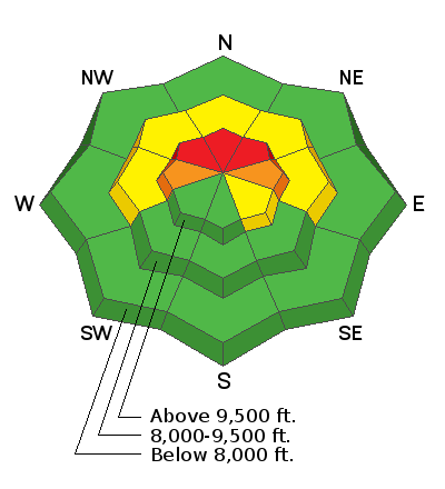
Low
Moderate
Considerable
High
Extreme
Learn how to read the forecast here
Weather and Snow
Wow. The Skyline got clobbered yesterday and last night. This portion of storm very much exceeded my expectations. Most upper elevation locations picked up about a foot of new snow. However, the big winner was the Meadows in Ephraim Canyon where it really let loose and stacked up 20" new! There were numerous times where the snowfall rates were 2" per hour and even one period of 3" an hour!! Densities were very low coming in at around 5%! Amazing. This brings snow totals up to 3 feet or a bit more since Wednesday.
The west wind bumped up in speed for a while also. It wasn't outrageous but no doubt enough to blow snow into fresh drifts.
The storm is mostly finished and we may see some clouds clear later this afternoon.
Ad
Additional Information