Forecast for the Salt Lake Area Mountains

Trent Meisenheimer
Issued by Trent Meisenheimer for
Saturday, April 22, 2023
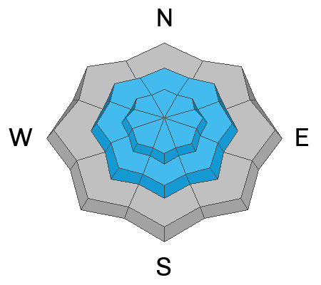
The avalanche danger is MODERATE at the mid and upper elevations for both New Snow and Wind-Drifted Snow avalanche problems. The danger is LOW at low elevations below about 8,000' where it mostly rained.
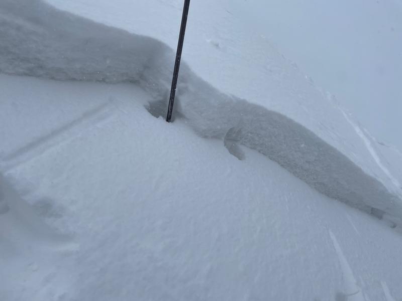
I am uncertain about cloud cover and whether the sun will come out today. Direct sun or green housing (warm temps from clouds) could instantly spike the avalanche danger, where the 3-6" of new dry snow would become wet and slide easily on the slick underlying surfaces.
Low
Moderate
Considerable
High
Extreme
Learn how to read the forecast here
Special Announcements
The last daily forecast will be Sunday, April 23. We will provide intermittent updates with any storm until Sunday, May 7th and will continue posting backcountry observations until then.
The UAC is sad to report that a resident was killed by a roof avalanche on Monday, April 17th, in the Town of Brighton. A report is available HERE. Many communities still have a lot of snow on roofs that could produce similar avalanches.
Weather and Snow
Snow totals from the past 48 hours are 3-6 inches of new snow (0.26-0.67" water), with some locally-higher amounts reaching 8".
This Morning: Under mostly cloudy skies, the mountain temperatures range from 16-27 °F. Winds remain out of the northwest and have slowed, blowing 5-15 mph across many upper-elevation ridgelines. However, at 11,000', the west-northwest winds are cranking with speeds of 45-50 mph, gusting to 60 mph.
Today: We will remain under a northwest flow with temperatures climbing into the mid to low 30s °F. Clouds should stay over the mountains, and any snowfall this morning will quickly turn into snow showers and broken skies later in the afternoon once the northwest flow decreases and high pressure begins to build in. Winds will remain from the northwest and blow 5-15 mph across many upper elevations. Remember that free air up around 11,000' is blowing much stronger.
Yesterday: we found the best riding and turning conditions on low-angled smooth slopes where the 3-6" of new snow rode like soft velvet and kept you off the bottom. We descended some very steep northerly facing terrain, and it was dust on crust while you dodged frozen roller balls and old tracks. Still fun.
Recent Avalanches
Through Instagram, I found one account reporting a small wind slab in Cardiff Fork. The avalanche was skier triggered and was 3-6 inches deep by roughly 50 feet wide, and it ran 200 vertical feet downhill. The party reported that it picked up speed fast as it ran on the smooth bed surface. Otherwise, there were a few observations from yesterday that you can find HERE.
Ad
Avalanche Problem #1
Wind Drifted Snow
Type
Location
Likelihood
Size
Description
Shallow, soft slabs of wind-drifted snow will be found at the mid and upper elevations. These wind drifts will mostly be found on aspects facing north through, east and southeast, but you also may discover fresh wind drifts on any aspect at the mid and upper elevations due to cross-loading. Also, watch for sensitive cornices along exposed ridgelines.
With a smooth bed surface, any avalanches may run fast and far.
Photo: Kelly & Meisenheimer observation: Showing the depth (3-6") of the wind slab we found yesterday.
Avalanche Problem #2
New Snow
Type
Location
Likelihood
Size
Description
In the past 48 hours, we've seen roughly 3-6 inches of new snow across the mid and upper elevations (rain below about 7,000'). This new snow may or may not bond well to all the slick and frozen surfaces.
Yesterday we found the new snow to be unreactive except in some steep terrain where the new snow would sluff easily, running on the smooth underlying bed surfaces. Today will be a good day to watch those sluffs and be on the lookout for shallow soft slabs. Slope cuts should be an effective tool.
Avalanche Problem #3
Wet Snow
Type
Location
Likelihood
Size
Description
I don't know if this avalanche problem will come to fruition today. However, it's April and the sun is intense. Any direct sunshine or "green housing" could instantly spike the avalanche danger on any aspect or elevation, allowing the 3-6 inches of new dry snow to become damp, wet, and avalanche. Keep an eye to the sky and watch those snow surfaces to make sure they aren't becoming wet. These loose wet avalanches would be shallow but could run long distances on the old frozen surface below.
General Announcements
This information does not apply to developed ski areas or highways where avalanche control is normally done. This forecast is from the U.S.D.A. Forest Service, which is solely responsible for its content. This forecast describes general avalanche conditions and local variations always occur.