Forecast for the Salt Lake Area Mountains

Drew Hardesty
Issued by Drew Hardesty for
Monday, March 25, 2019
The avalanche danger will rapidly rise to CONSIDERABLE for wet avalanches on all steep sunlit slopes today with sun and warming.
Natural and human triggered wet loose and wet slab avalanches are certain on east, then south, then west facing slopes...and even include low and some mid elevation northerly terrain. AVOID BEING ON OR BENEATH STEEP SUNLIT SLOPES BY THE TIME THEY'VE BECOME WET AND UNSTABLE.
ADDITIONAL KEY POINT FOR TODAY: Don't sluff your bro or the road below.
Low
Moderate
Considerable
High
Extreme
Learn how to read the forecast here
Special Announcements
We need your help. In an effort to increase awareness and prevent future fatalities we need to reach more people with our daily avalanche forecasts, expand the Know Before You Go program, and increase the number of on-snow avalanche courses. Please consider a donation to the UAC to help us raise $25,000 by April 8. Help your support of the UAC by making a donation HERE. Thank you -
Weather and Snow
Severe clear.
Mountain temperatures are in the mid to upper teens.
Winds are westerly, blowing 10-15mph with gusts to 20. Along the highest peaks and ridgelines, the anemometers spin 25-30mph with gusts to 40.
Yesterday's burst of snowfall added up to 4-8" in the span of a few hours with 1-2' storm totals since last Thursday.
For today, we'll have clear skies, diminishing west to southwest winds, and skyrocketing temperatures to near 50°F in the mountains. Ridgetop temps will rise to the mid-30s. It'll be sweltering out there -
The HEAT WAVE will continue through Wednesday night with ridgtop temps rising to near 40°F with poor-at best-overnight refreezes. A cold front arrives with relief early Thursday morning.
Recent Avalanches
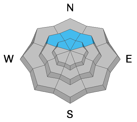
Higher-than-expected snowfall rates combined with heavier-over-lighter density snow led to quite an active morning in the storm snow yesterday but things trended more stable in the afternoon. Many - if not most - backcountry observers noted storm snow instabilities 6-10" deep and 50' wide on all aspects at the mid and upper elevations with one notable accident in upper Cardiac Bowl of upper Cardiff Fork (BCC). In this avalanche (NE@10,600'), reported as a foot deep and 500' wide, six people were caught and carried, with two buried to their waist or neck with two suffering non-lifethreatening injuries, including a blown knee and a dislocated shoulder. The preliminary report is found HERE. Terrain photo of Cardiac Bowl below -
With sunbreaks and some greenhousing, backcountry parties were able to initiate 8-12" damp push-alanches in the low and mid-elevations, running easily on the slick underlying crusts.

More reports and photos can be found in the Menu above (Observations and Avalanches)
Ad
Avalanche Problem #1
Wet Snow
Type
Location
Likelihood
Size
Description
The cold dry storm snow will turn on a dime today with the direct sun and skyrocketing temperatures and all the recent storm snow will run fast and far on the underlying crusts on the east, then south, then west facing slopes. Wet loose and (possibly) wet slab avalanches are certain on these sunlit slopes. Cement-like debris piles will be impressive under the steepest, most sustained terrain. Low to mid elevation shady slopes will also become unstable with the dramatic warming and may gouge into unconsolidated wet grains below (creating a much larger avalanche).
Initial signs of instability include rollerballs, pinwheels, initially small sluffs. These are signs to seek colder aspects or low angle terrain.
Timing is key. If you're reading this, you're probably too late to be on any steep sustained slopes that'll see direct sun and heating. Plan your descents and exits accordingly.
Avalanche Problem #2
New Snow
Type
Location
Likelihood
Size
Description
Yesterday's storm snow instability peaked in the mid-morning hours, but one may still trigger a lingering soft slab avalanche up to a foot deep along the highest elevation northerly aspects. By the afternoon, most of these will have settled out entirely.

CORNICES will become more sensitive as they sag in the sweltering heat. These have become enormous this winter and destruction from cornice failure has been well observed and documented this week. INFO.
ROOF-ALANCHES are also expected with the sun and temperatures. PLEASE spread the word to other homeowners in the mountains. Roof-alanche fatalities have occurred in the West this year with many close calls.
GLIDE CRACKS ARE WIDENING. Avoid being under the widening glide cracks noted in upper Cardiff, Mill B, Broads, Stairs, and upper Porter Fork of BCC. Most of these are mid/upper elevation northeast facing.
General Announcements
This information does not apply to developed ski areas or highways where avalanche control is normally done. This forecast is from the U.S.D.A. Forest Service, which is solely responsible for its content. This forecast describes general avalanche conditions and local variations always occur.