Forecast for the Salt Lake Area Mountains

Greg Gagne
Issued by Greg Gagne on
Friday morning, February 7, 2025
The avalanche danger is MODERATE on all aspects at the mid and upper elevations where there are sensitive soft slabs of wind-drifted and storm snow.
Watch for rapidly changing conditions - especially this afternoon - when strong winds and heavy snowfall could bump the danger to CONSIDERABLE with natural avalanches possible.
On mid and upper-elevation northerly-facing slopes, avalanches may break down into old, faceted snow 1-3 feet deep.
Low
Moderate
Considerable
High
Extreme
Learn how to read the forecast here
Special Announcements
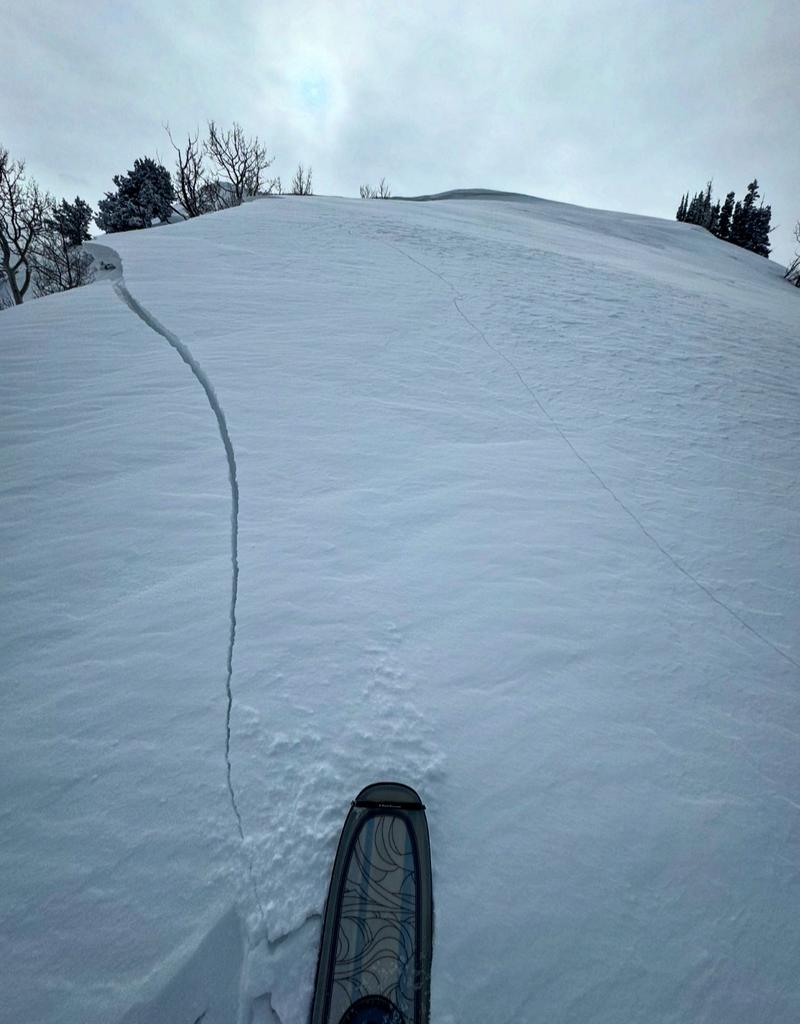
The Preliminary Report for Monday's Monte Cristo avalanche fatality is HERE.
Our condolences go out to the victim's friends and family and all those affected by this tragic accident. UAC staff visited the site on Tuesday and a full report is forthcoming.
Weather and Snow
This morning: Temperatures are 25-30° F, and winds are from the south and strong - gusting into the 40's and 50's mph along exposed ridges and summits above 9,500'. This is ahead of a cold front expected to arrive by early afternoon. Some graupel has been reported.
Today: Temperatures will rise only a few degrees and light snowfall is possible this morning, with steady snowfall beginning early afternoon. Winds will remain strong as they veer from south to west, and finally northwest by early evening. The rain/snow line will start around 7,500' and drop through the day, with periods of heavy snowfall possible this afternoon. Snow may continue into the evening in areas favored by a northwest flow, such as Little Cottonwood. 6-10 inches of new snow is expected by Saturday morning.
This Weekend: Sunny with seasonable - finally! - temperatures through the weekend. We may see some light snow showers mid-week, with an active weather pattern possibly returning by late week.

Be sure to read Nikki's Week in Review and make it a regular part of your backcountry planning.
Recent Avalanches
No backcountry avalanches were reported from Thursday, although we continue to receive reports of avalanche activity from earlier this week, including widespread natural activity in Broads Fork, Donut Falls (Cardiff Fork), and Lucky Days (Days Fork), with most of this activity involving wet snow.
Ad
Avalanche Problem #1
Wind Drifted Snow
Type
Location
Likelihood
Size
Description
Although the relentless winds over the past six days may have finally run out of loose snow to transport, today's winds will have new snow to work with, and you can expect fresh drifts to form on all aspects at the mid and upper elevations. Any fresh wind drifts may fail at the existing snow surface, or on slopes facing northwest through east, step down 1-3 feet into buried weak layers.
Cornices have grown large over the past week and continue to be sensitive - be well back from the edge when traveling on corniced ridgelines.
Avalanche Problem #2
New Snow
Type
Location
Likelihood
Size
Description
The new snow may be reactive by this afternoon, especially during any period of high precipitation intensity. Watch for cracking as an indication of sensitive soft slabs of new storm and/or wind-drifted snow, such as the photo below from Mark White.
Avalanche Problem #3
Persistent Weak Layer
Type
Location
Likelihood
Size
Description
There are two buried persistent weak layers (PWL) in the snowpack:
1. The upper layer buried down 12-18 inches that formed during cold, clear weather in late January and has been buried by recent storm and wind-drifted snow. Many recent avalanches involving wind slabs are failing at this layer.
2. The lower layer, near the ground, formed in December and has caused large avalanches, including two fatalities during the Holiday Avalanche Cycle. This layer is most problematic on repeater slopes that have previously avalanched this winter. (Click here for a list of avalanches since December 1.)
General Announcements
This information does not apply to developed ski areas or highways where avalanche control is normally done. This forecast is from the U.S.D.A. Forest Service, which is solely responsible for its content. This forecast describes general avalanche conditions and local variations always occur.