Forecast for the Salt Lake Area Mountains

Dave Kelly
Issued by Dave Kelly for
Monday, February 5, 2024
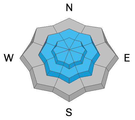
The avalanche danger is CONSIDERABLE at the upper elevations where humans are likely to trigger wind-drifted snow avalanches; these avalanches could step down to the buried Persistent Weak Layer. The avalanche danger is MODERATE at mid-elevations where human triggered avalanches are possible. There is a LOW danger at low elevations.

If you trigger an avalanche into the buried Persistent Weak Layer, it could break 3'-5' deep and well over a 100' wide failing on a weak layer of facets buried near the ground.
Low
Moderate
Considerable
High
Extreme
Learn how to read the forecast here
Special Announcements
There is a NEW beacon training park in Park City near the Park City Day School. More info HERE.
Join Craig Gordon this Tuesday, February 6th from 6:00-7:30 for a State of the Snowpack presentation at Black Diamond Equipment
Weather and Snow
This morning, under overcast skies there is light snow blowing sideways across the mountains. Trailhead temperatures are much warmer today than yesterday hovering around 30°F while the highest ridgelines are in the low 20's°F. Winds have increased and shifted blowing from a southerly direction 20 gusting to 40 MPH at the 9,000' ridgelines and 30 gusting to 55 MPH at the 11,000' ridgelines with a few overnight gusts near 75 MPH. Overnight there were reports of 1"-2" of wind-affected snow with .10"-.20" of water.
Today, strong southerly winds will continue blowing 25-30 gusting to 50MPH at the 9,000' ridgelines and 40 gusting to 70 MPH at the 11,000' ridgelines. Temperatures will be 32°-36°F. There is a chance of 1"-4" of high-density snow(.10"-.40" water) with an off chance of 4-7"snow (.4"-.7" water)in areas favored by southerly flow. The freezing level will be 6,000' rising to 7,000' with daytime warming.

These strong winds are the precursor to a multi-day winter storm that will bring heavy mountain snow to the forecast area. Read more from our partners at the National Weather Service HERE who have issued a Winter Storm Watch.
Recent Avalanches
Yesterday, in both the backcountry and ski resorts, there were reports of sensitive slabs of new and wind-drifted snow as well as avalanches failing into the buried Persistent Weak Layer. Avalanches in Hidden Canyon in upper Big Cottonwood Canyon (see photo below) and in Days Fork that match the pattern of PWL avalanches we have been seeing. This avalanche on Cardiac Ridge is more of the new snow variety and this human-triggered avalanche in Lake Chute is more wind-drifted. And not to be left out there were reports of wet loose avalanches at lower elevations on Reynolds.

This chart below from the UAC Data Explorer highlights the size of the avalanches you may see if you trigger an avalanche into the buried PWL.
Ad
Avalanche Problem #1
Wind Drifted Snow
Type
Location
Likelihood
Size
Description
Southerly winds blew all day yesterday at the highest ridgelines and increased overnight. You're likely to encounter sensitive slabs of wind-drifted snow on upper and mid-elevation terrain features. These slabs of wind-drifted snow will be most noticeable on leeward-facing slopes, but keep in mind that high winds can load any aspect due to swirling and changing wind directions as they navigate the mountains.
Watch out for signs of wind-drifted snow, like pillow-shaped deposits, and steer clear of those slopes. The most favorable riding conditions will be in sheltered, lower-angle terrain out of the wind.
This avalanche below was triggered in Lake Chute yesterday. Today, you can expect to find much stiffer slabs of wind-drifted snow that may allow you to get further out on the slope before they break above you.
Video credit: Christoph
Avalanche Problem #2
Persistent Weak Layer
Type
Location
Likelihood
Size
Description
Avalanches continuing to fail in the persistent weak layer (PWL) over the past week indicate that this avalanche problem remains a concern. Steep, shallow, and rocky terrain features are locations where you are most likely to trigger an avalanche breaking into this layer.

Overall, the likelihood or possibility of triggering an avalanche on this layer has decreased over the past few weeks, but the consequences of triggering an avalanche on this layer remain the same. With the upcoming storm bringing additional snow and water weight and strong southerly winds the likelihood of triggering an avalanche on this layer will begin rising today through the next few days.
Photo of crown face from Hidden Canyon (Photo credit: Brighton Ski Patrol). This avalanche crown was 4' deep and broke on facets near the ground in a steep, rocky, thin area.
Additional Information
If you trigger an avalanche in the backcountry, AND NO ONE IS HURT or needs help, please notify the nearest ski area dispatch to avoid a needless response by rescue teams. If someone is injured or you need help call 911.
Salt Lake and Park City – Alta Central (801-742-2033)
Canyons Resort/PCMR Dispatch (435 -615-1911)
General Announcements
This information does not apply to developed ski areas or highways where avalanche control is normally done. This forecast is from the U.S.D.A. Forest Service, which is solely responsible for its content. This forecast describes general avalanche conditions and local variations always occur.