Forecast for the Salt Lake Area Mountains

Trent Meisenheimer
Issued by Trent Meisenheimer for
Thursday, February 22, 2024
Today, the avalanche danger is CONSIDERABLE across the mid and upper-elevation slopes that face east, southeast, south, southwest, and west, where you can trigger a persistent weak layer avalanche that breaks to a crust with faceted snow 1-3 feet deep.
We also have a CONSIDERABLE avalanche danger across all upper-elevation terrain for both hard or soft slabs of wind-drifted snow. Avalanches can fail 1-3 feet deep and hundreds of feet wide. Careful route-finding and conservative decision-making will be essential today.
Low
Moderate
Considerable
High
Extreme
Learn how to read the forecast here
Special Announcements
Join the UAC and Inspired Summit Adventures for the grand opening of our new Transceiver Training Park at Pinebrook, Sunday, February 25, from 3:00-6:00PM.
Weather and Snow
Under mostly cloudy skies, the mountain temperatures have finally cooled off and range from 15-20 °F. Winds from the northwest blow 10-15 mph across most upper elevations. Above 10,000', the wind is a bit stronger and blows from the northwest at 20-30 with gusts into the 30s.
Today, we can expect mostly cloudy skies with some snow showers in places this morning. As the day wears on, a short period of high pressure will build into the area. We will see mountain temperatures rising into the low to mid-30s °F with partly cloudy to clear skies. The wind will remain from the northwest today, blowing 10-20 mph across the upper elevation.
In the past 24 hours, we picked up another 5-10 inches of new snow (.35-1.25" swe). This Brings the total in the Upper Cottonwoods since Valentine's Day to roughly 57" of snow with 5.92 inches of water. Huge totals. Across northern Utah for the past four days (since February 19), the storm totals are roughly:
  • Upper Cottonwoods: 12-27" snow (2.03-3.20" swe)
  • Park City Ridgeline: 10-17" snow (1.5-1.94" swe)
  • Provo Mountains: 8-12" snow (2.78 swe)
  • Ogden Mountains: 18-29" snow (2.35-2.71" swe)
Recent Avalanches
Four avalanches were reported from the backcountry yesterday. One rider on East Bowl of Silver Fork triggered a small 8" x 25' wind slab on a slope cut; they were caught and carried 200-300' downhill, deployed an airbag, lost a ski, and thankfully, had no injuries.
The other avalanche that caught my eye was in 
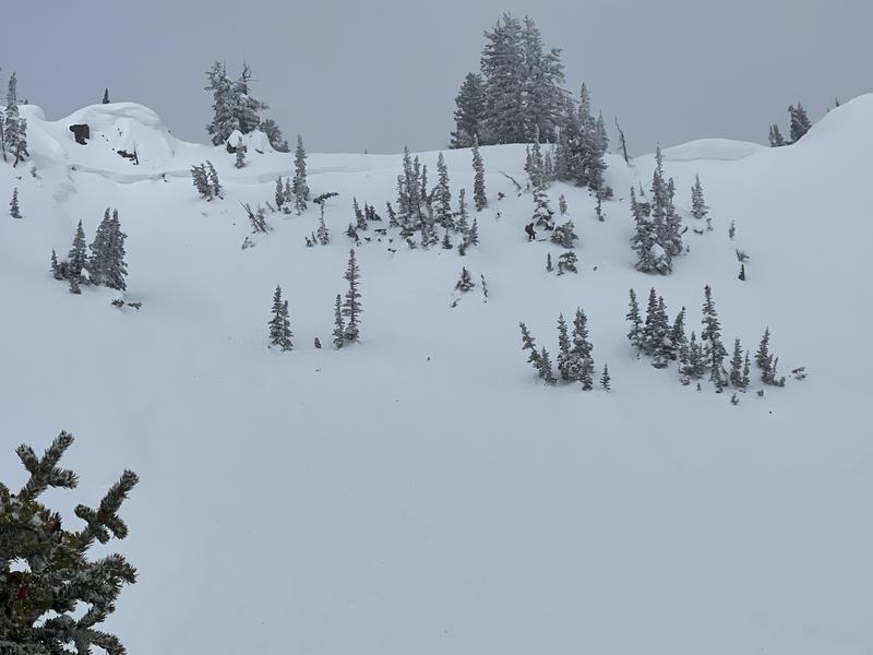
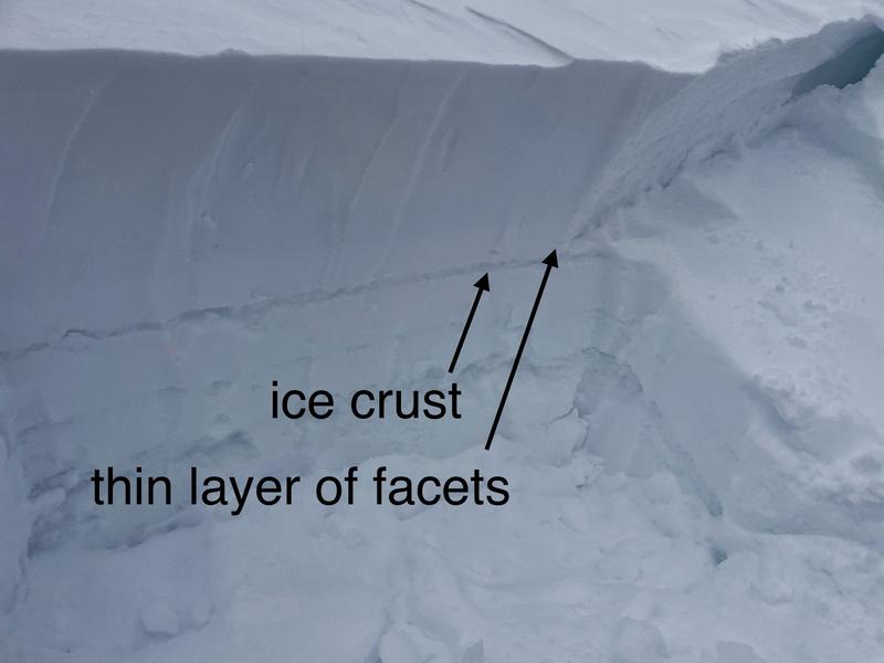
Caribou Basin (backside of Brighton). This was on a southeast aspect, and the avalanche failed 2' deep x 100 ' wide likely failing on the crust faceted interface that was buried on Valentine's Day (photo below). There was also a report of a large booming collapse on a southeast-facing slope on peak 10,420 in upper Big Cottonwood.
Avalanche in White Pine, Dog Dish, 14" deep x 300' wide. This was likely a new snow soft slab avalanche. The width is alarming to me.
Ad
Avalanche Problem #1
Persistent Weak Layer
Type
Location
Likelihood
Size
Description
Heads up: On Valentine's Day, we buried and preserved a thin crust with faceted snow above or below it. This crust can be easily found by digging down 1-4 feet deep on southerly-facing terrain. Yesterday's avalanche in Caribou Basin is the perfect example of how this layer is still in play.
The issue is complicated as it varies from slope to slope and by elevation. Because of this, I recommend avoiding steep south-facing terrain for now. There is plenty of power on the north side of the compass where this layer does not exist.
Photo: Mark Staples showing the snowpack structure.
Avalanche Problem #2
Wind Drifted Snow
Type
Location
Likelihood
Size
Description
Strong wind and heavy snowfall have created unstable avalanche conditions across many aspects and elevations. Strong wind has whipped up the new snow, creating sensitive soft or hard slabs of wind-drifted snow. Avalanches could fail 1-4 feet deep on a variety of density changes within the recent storm snow.
I would wait and let the snowpack settle over the next 24-48 hours before venturing into steep avalanche-prone terrain. As Drew Hardesty classically said last year, "The glue is yet to dry."
Avalanche Problem #3
New Snow
Type
Location
Likelihood
Size
Description
New snow, soft slabs, could fail in various layers in the snowpack as seen in the Dog Dish avalanche from yesterday. For the past four days, the storm has been warm/cold/warm/cold/warm, changing the density of new snow. Along with the warm and cold were also periods of graupel within the new snow. This makes the new snow layered and potentially unstable. Graupel tends to pool below the steeper slopes and below cliff bands and these are likely spots to trigger an avalanche.
For today, I would approach any steep slope or break-over with the suspicion that you can trigger an avalanche within the new storm snow. Shovel tilt tests and using small test slopes are good tools to test how the snow is reacting. If you decide to get into steeper terrain, I would throw in the last ditch effort of a slope cut before going fall-line.
If the sun comes out and heats the southerly facing terrain look for roller balls and wet-loose avalanches. If it becomes wet, saturated, and unsupportable it's time to get out from under and off steep sunlit terrain.
Additional Information
North-facing terrain: The early season faceted snow is now buried 4-8' deep. This layer has gained strength and is becoming more and more unlikely to be triggered. This problem is isolated to steep, unsupported, thin rocky terrain. Trending dormant.
General Announcements
This information does not apply to developed ski areas or highways where avalanche control is normally done. This forecast is from the U.S.D.A. Forest Service, which is solely responsible for its content. This forecast describes general avalanche conditions and local variations always occur.