Check out our Holiday Auction - Sign Up for the Utah Snow and Avalanche Workshop (USAW)

Forecast for the Salt Lake Area Mountains

Mark Staples
Issued by Mark Staples on
Saturday morning, December 9, 2023
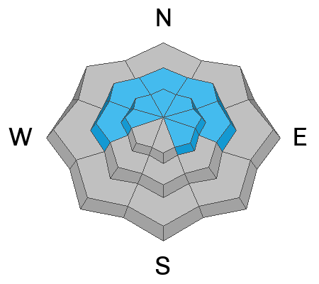
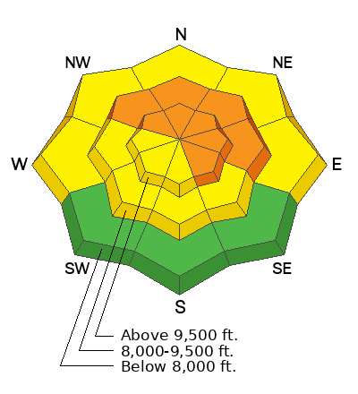
Today the avalanche danger remains CONSIDERABLE on northwest, north, and northeast-facing slopes above 8000 ft as well as southeast-facing slopes above 9500 ft. Deadly slab avalanches may break 3-4 feet deep on a persistent weak layer, possibly hundreds of feet wide in these areas.
Most other slopes have a MODERATE avalanche danger where the main threat is soft slabs of new snow 1-2 feet thick. Low elevation south-facing slopes have a LOW danger.
Travel advice - Today will have amazing riding on sunny south-facing slopes with cold powder. A great option is avoiding avalanche terrain and slopes steeper than 30 degrees. If getting into steeper terrain, stay on south facing slopes (avoiding upper elevation southeast) and try to avoid places where strong westerly winds yesterday morning drifted snow (they will be hard to see).
Low
Moderate
Considerable
High
Extreme
Learn how to read the forecast here
Special Announcements
If you trigger an avalanche in the backcountry, AND NO ONE IS HURT or needs help, please notify the nearest ski area dispatch to avoid a needless response by rescue teams. If you need help call 911.
  • Salt Lake Cottonwood Canyons – Alta Central (801-742-2033)
  • Park City Ridgeline - Park City Mountain Dispatch (435-615-1911)
Please avoid entering ski area boundaries as they continue to set up their resorts and conduct avalanche control work.
Weather and Snow
What a storm! Snow fell a little on Thursday and all day Friday. Storm totals (snow/water) are:
  • Little Cottonwood: 23-28" (1.6-1.8")
  • Big Cottonwood: 15-22" (1.2-1.6")
  • Park City Ridgeline: 10-16" (1-1.4")
These storm totals bring the total snow depth up to 28" at trailheads like Spruces, 45" in higher terrain of BCC, and up to 74" in higher terrain of LCC.
This morning it's cold with temperatures hovering around 10 deg F. Fortunately winds from the NW are generally light, averaging 3-8 mph with gusts up to 15 mph. Winds blew much stronger yesterday morning from the WNW averaging 15-25 mph, gusting 30-40. Winds at 11,000 ft averaged 40 mph with gust to 60 mph.
Today will be sunny with temperatures only rising to about 15 degrees F, and fortunately, winds will remain light.
Snow conditions are about as good as they can get - light winds, cold temps, and blower powder on top of a soft old snow surface with a supportable base from last weekend's big storm. Coverage is still a bit thin at low elevations but quite good above about 9000 ft.
Recent Avalanches
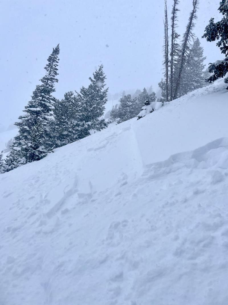
Reported avalanches yesterday mostly involved soft slabs of the new snow and wind drifted snow. Ones on south facing slopes looked like this:
(Photo J. Lemnotis)

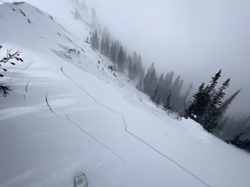
Several avalanches were triggered along the Park City Ridgline which seems to have weaker & thinner snow further south. Most occurred on wind loaded slopes like one in the photo below that was remotely triggered on a Northeast aspect. Another happened in an area with only 2-3 feet of total snow on an East aspect.
(photo N. Grainger)
Ad
Avalanche Problem #1
Persistent Weak Layer
Type
Location
Likelihood
Size
Description
There is a persistent weak layer of old, weak, and faceted snow from November near the ground. It has a thick slab on top of if from last weekend's major storm plus yesterday's additional 1-2 feet of snow. Avalanches on this layer will be deep and break over huge areas.
This is a very tricky situation. In many places, avalanches on this layer are becoming harder to trigger because it is gaining strength and buried 3 feet deep. Areas with thinner snow (like the southern end of the Park City Ridgeline or maybe places in Mill Creek Canyon) will be more sensitive. Areas with the additional load of wind drifted snow could also be more sensitive.
It's only December 9th and generally this layer is on the road to recovery, so be patient. I'd keep it simple and ride south facing slopes today to avoid this problem. Watch out for upper elevation Southeast facing slopes that may harbor this layer.
Avalanche Problem #2
New Snow
Type
Location
Likelihood
Size
Description
Yesterday while sking in Big Cottonwood Canyon, I could find evidence that the new snow was beginning to become a soft but cohesive slab (try walking or riding above another person's track) that would crack just a little. Areas where strong westerly winds deposited snow yesterday morning will be the mostly likely places to trigger a soft slab of new snow. The challenge is that these wind drifted areas will be camouflaged with fluffy new snow that fell yesterday afternoon.
What to do? Riding slopes less than 30 degrees is always a great option to avoid avalanches. Stick to the basics and only expose one person at a time, ride slopes wth a clear runout so that an avalanche doesn't slam you into trees or rocks, and do your best to avoid slopes where yesterday morning's strong westerly winds drifted snow.
General Announcements
This information does not apply to developed ski areas or highways where avalanche control is normally done. This forecast is from the U.S.D.A. Forest Service, which is solely responsible for its content. This forecast describes general avalanche conditions and local variations always occur.