Sign Up for the Utah Snow and Avalanche Workshop (USAW) on December 7th!

Forecast for the Salt Lake Area Mountains

Mark Staples
Issued by Mark Staples on
Thursday morning, December 31, 2020
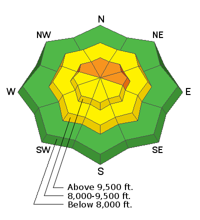
The most likely place to trigger an avalanche today will be upper elevation slopes facing NW, N, NE, & E especially if they have some wind-blown snow on them. The avalanche danger is CONSIDERABLE in these locations.
Otherwise, triggering an avalanche has become harder to do, and the danger is MODERATE on other upper elevation slopes and on all mid elevation slopes.
A LOW avalanche danger exists on all low elevation slopes.
Low
Moderate
Considerable
High
Extreme
Learn how to read the forecast here
Special Announcements
The Utah Avalanche Center podcast's second episode of season 4 is live - Managing Risk with Avalanches, Managing Risk with a Pandemic - A Conversation with state epidemiologist Dr. Angela Dunn.
Stream here or tune in wherever you get your favorite podcasts

Read a few short anecdotes in a blog from UAC staff about how avalanches can surprise us

Thanks to the generous support of our local resorts, Ski Utah, and Backcountry, discount lift tickets are now available. Support the UAC while you ski at the resorts this season. Tickets are available here.
Weather and Snow
This morning it's snowing with a trace of snow as of 5 a.m. Temperatures are generally in the mid teens F at all elevations. At many trailheads these temperatures are 10-15 degrees warmer than the bitter cold temperatures yesterday morning. Winds yesterday shifted from the northwest to west and then southwest this morning blowing 7-10 mph.
Today an inch of two of snow should accumulate mainly this morning. Skies will remain cloudy and temperatures will struggle to break into the 20s F. Winds should remain light and slowly shift and come from the northwest.
This weekend will be dry, but some snow could come Monday night and again Wednesday night. No major accumulations are expected but we'll take what we can get.
Riding conditions are quite good with several inches of snow from last Monday night and generally supportable snow underneath. Southerly facing slopes have some powder on top of supportable crusts. For snowmobilers, the snow is still so thin that it's a game of Russian Roulette with your a-arms. Even skiers and boarders should still be extra cautious about hitting rocks.
Recent Avalanches
There was one small avalanche spotted yesterday in Broads Fork. Cracking and loud audible collapses continue to be reported by many especially in less traveled areas like Box Elder, Broads Fork, Maybird, and Mill B South. Snowpit tests continue to show propagation (video below from Grizzly Gulch), meaning that avalanches can still be triggered.
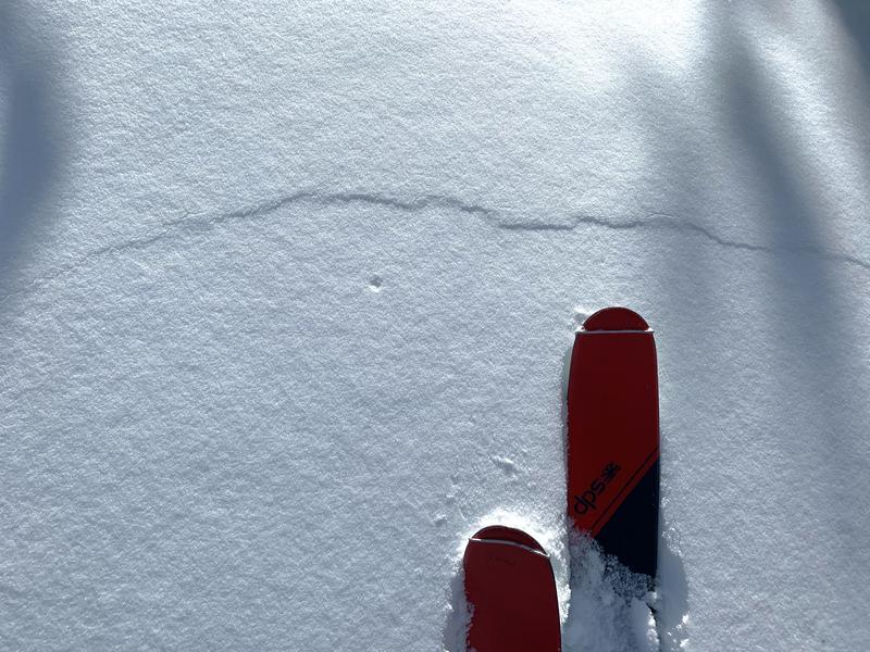
Photo below of a crack in the snow where it collapsed in Maybird Gulch. Seeing this is the equivalent of seeing an avalanche except the slope isn't steep enough to slide (A. Bellomy).
Ad
Avalanche Problem #1
Persistent Weak Layer
Type
Location
Likelihood
Size
Description
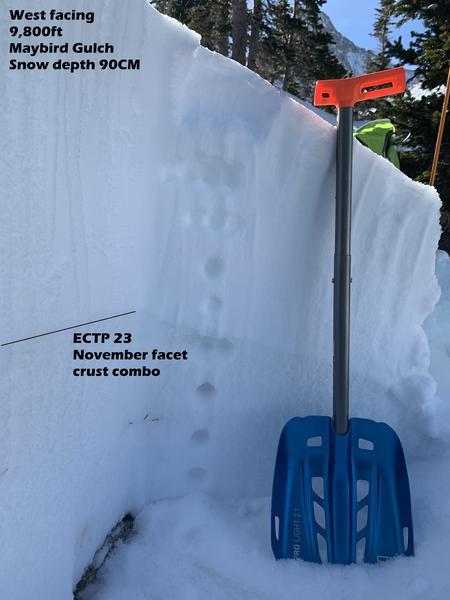
There are multiple layers of weak snow generally in the bottom half of the snowpack. Some formed in November, some in early December, some in mid December, and some in late December. To be honest, it's hard for me to keep track of them all, but it doesn't really matter. These persistent weak layers have a layer of snow on top of them that is cohesive enough to be a slab. The photo (A. Bellomy) below shows the general snowpack structure - the bottom half is faceted and weak, the upper half is the slab.

The likelihood of triggering a slide has decreased a little, but the snowpack continues to tell us it is unstable with widespread collapsing, cracking, and audible whumpfs. The trouble is that you won't experience this in many places with lots of tracks where these collapses have already been triggered.

The most likely places to trigger a slide today are slopes with some wind-loading especially on more northerly facing slopes with the weakest snow. The little extra weight of wind drifted snow keeps the buried facets stressed and ready to fracture.
Where to ride today? Two options exist:
  1. Ride slopes less than 30 degrees that aren't steep enough to slide.
  2. Ride slopes facing south where this persistent weak layer generally doesn't exist and avoid pockets of wind drifted snow. These slopes don't have much snow but have become much more supportable.
General Announcements
Please visit this website with information about Responsible Winter Recreation by the Utah Office of Outdoor Recreation.

This information does not apply to developed ski areas or highways where avalanche control is normally done. This forecast is from the U.S.D.A. Forest Service, which is solely responsible for its content. This forecast describes general avalanche conditions and local variations always occur.