Join us for the 17th Annual Professional Snow and Avalanche Workshop (PROSAW) on November 4 - Purchase tickets here!

Forecast for the Salt Lake Area Mountains

Greg Gagne
Issued by Greg Gagne on
Friday morning, December 30, 2022
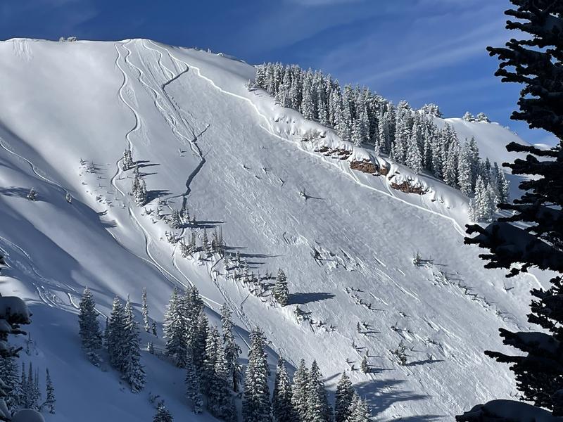
The avalanche danger is CONSIDERABLE on all aspects at the mid and upper elevations where avalanches involving soft slabs of new snow or wind-drifted snow are likely. On slopes facing northwest through east, avalanches may break down 2-6' on a buried persistent weak layer of faceted snow.
The avalanche danger is MODERATE at low elevations.
The avalanche danger could rise to HIGH this afternoon during any period of heavier snowfall or wind-drifting.

The avalanche danger will increase this evening with very dangerous avalanche conditions expected through at least this weekend.
Low
Moderate
Considerable
High
Extreme
Learn how to read the forecast here
Avalanche Watch
What The avalanche danger is expected to be HIGH.
When In effect from 6am MST this morning to 6am MST Saturday
Where For most mountains in Utah including Wasatch Range, Bear River Range, Uinta Range, Manti-Skyline, La Sal and Abajo Ranges, Fish Lake Region, Pavant Range, Tushar Range, and Cedar City area mountains.
Impacts Very dangerous avalanche conditions are expected as a series of storms will arrive this weekend with significant snowfall, substantial water amounts, and very strong winds. Both human-triggered and natural avalanches will become likely. Stay off of and out from under slopes steeper than 30 degrees.
Warning Times Friday, December 30, 2022 - 6:00am to Saturday, December 31, 2022 - 6:00am
Special Announcements
Check out this great blog post that Dave put together discussing the persistent weak layer, and the forecaster's current mindset while dealing with it. You can read the full post HERE.
Weather and Snow
Temperatures this morning are in the low teens and winds are westerly and moderate, with gusts near 20 mph at the mid elevations and gusting into the upper 20's mph along the highest ridgelines.
The National Weather Service has issued a winter storm warning through Monday morning. Snowfall will begin this morning and increase in intensity later this afternoon, with 7-12" expected by early evening. Winds will be from the southwest with increasing wind speeds later this afternoon. At mid elevations winds will average in the teens mph with gusts in the 20's while the highest peaks and ridges will average in the upper 20's mph and gusts near 50 mph. Temperatures will range through the 20's F.
Strong winds and heavy snowfall overnight and lasting throughout the weekend. By Monday morning, storm totals in the upper Cottonwoods will potentially reach 3-5' containing 3-5" of water.
Recent Avalanches
On Thursday, a skier was caught and carried in Dutch Draw. The avalanche occurred on an east aspect at 10,000' and was 3' deep, 350' wide, and ran 700' vertical. UAC staff hopes to visit the site this morning before the onset of heavier snowfall. (Photo: Craig Gordon)
Other reported avalanche activity includes Summit Park (2' deep, 50' wide, running on facets at 7,400') and Soldier Peak (up to 3.5' deep and 70' wide, running on facets at 8,000').
Ad
Avalanche Problem #1
Persistent Weak Layer
Type
Location
Likelihood
Size
Description
Most avalanche activity failing on the persistent weak layer (PWL) of faceted snow has been on northerly-facing terrain, however the PWL does exist on other aspects at the mid and upper elevations, including some southerly aspects. Snowfall this past week didn't seem to be enough of a load to produce widespread avalanching on this weak layer that is now buried 2-4' deep, but heavy snowfall containing 5" of water that may potentially fall through this weekend will find any weakness in the snowpack, with large and dangerous avalanches very likely.
Trend: Increasing
Avalanche Problem #2
New Snow
Type
Location
Likelihood
Size
Description
Although I'm not expecting snowfall rates to increase until this evening, storm snow may be reactive during any period of heavier precipitation intensity or increase in winds. Watch for cracking or long-running sluffs as signs of instabilitity in the new snow.
Trend: Increasing
Additional Information
Check out this weather discussion that Mark and I had talking about the forecast, and areas of certainty versus uncertainty within the snowpack.
General Announcements
Help support the UAC while doing your Holiday Shopping. The UAC's Holiday Silent Auction opens at 8:00 AM MT on December 26 and will close at 8:00 PM MT on January 2. Take a look at items and bid HERE.

This information does not apply to developed ski areas or highways where avalanche control is normally done. This forecast is from the U.S.D.A. Forest Service, which is solely responsible for its content. This forecast describes general avalanche conditions and local variations always occur.