Check out our Holiday Auction - Sign Up for the Utah Snow and Avalanche Workshop (USAW)

Forecast for the Salt Lake Area Mountains

Drew Hardesty
Issued by Drew Hardesty on
Monday morning, December 11, 2023
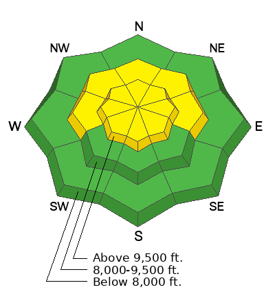
A MODERATE avalanche danger exists in much of the steep terrain of the mid and upper elevations. On westerly to northerly to easterly facing aspects it will still be possible to trigger an avalanche 1-4' deep stepping into the old faceted snow from early season. Cracking and collapsing may or may not accompany unstable slopes. Avalanches may still be triggered at a distance.
A LOW avalanche danger exists on many southerly aspects and on all low elevation slopes.
Low
Moderate
Considerable
High
Extreme
Learn how to read the forecast here
Special Announcements
If you trigger an avalanche in the backcountry, AND NO ONE IS HURT or needs help, please notify the nearest ski area dispatch to avoid a needless response by rescue teams. If you need help call 911.
  • Salt Lake Cottonwood Canyons – Alta Central (801-742-2033)
  • Park City Ridgeline - Park City Mountain Dispatch (435-615-1911)
Please avoid entering ski area boundaries as they continue to set up their resorts and conduct avalanche control work.
Weather and Snow
Skies are partly cloudy. Mountain temperatures are in the mid to upper 20s. Winds are from the west-northwest, blowing 15mph with gusts to 25. The highest elevations have wind speeds of 25-30mph with gusts to 35.
The snow surface conditions are starting to show a little wear and tear from the last two days of sun and wind. Still, riding conditions remain excellent in sheltered terrain. Snow depths are 2-3' along the Park City ridgeline and 3-5' in the upper Cottonwoods.
For today, we'll have partly cloudy skies and perhaps near Logan a wayward snowflake or two by a weak system passing through. Don't complain, though, those flakes may be all we see for the next week or so. Temps will be in the upper 20s to low 30s; winds will be light from the west.
The Outlook: fairly grim. Plenty of sun, seasonal to above seasonal temps, and light wind. Mike Seaman, the lead meteorologist this morning at the National Weather Service, describes Utah as moving into the "No-Flow-Zone". In other words, we're in limbo between the main storm track to the north and a weak system that dives to the south. I might be grasping at straws here, but perhaps we'll see a pattern change around the Solstice.
The Good News: backcountry travel is easy, riding conditions will remain decent in the sheltered terrain, and avalanche conditions will improve.
Recent Avalanches
Forecaster Dave Kelly noted a new natural soft slab avalanche (wind drifted snow) on a steep northeast facing slope of Rocky Point (between Alta and Brighton). It was estimated to be 2' deep and 70' wide. Ski area control work did not produce any avalanches and we didn't hear about any other avalanches in the backcountry.
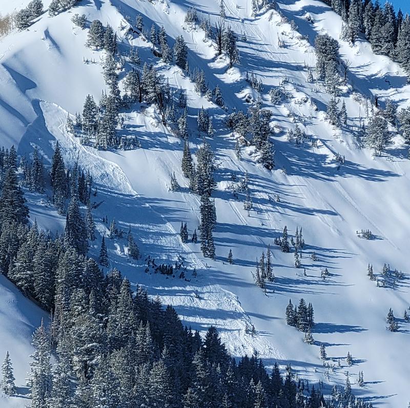
On Saturday, however, a backcountry party remotely triggered (at a distance from the ridgeline) a two foot deep and 125' wide soft slab in Wilson Fork in upper Mill Creek (Ambler pic below). This avalanche broke on our old weak faceted snow from early season on a steep northeast facing slope at 9600'. My own touring party experienced three large collapses along the Wilson ridgeline above the avalanche yesterday, but these did not trigger anything.
Ad
Avalanche Problem #1
Persistent Weak Layer
Type
Location
Likelihood
Size
Description
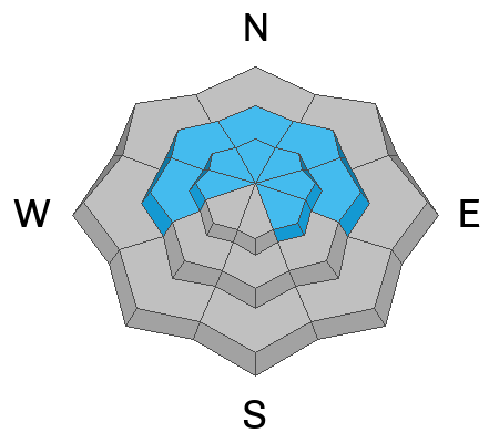
Triggering an avalanche 2-4' deep that fails on a (PWL) persistent weak layer is your primary issue for today. The central Wasatch experienced a widespread avalanche cycle on this layering last Sunday (8 days ago), and avalanches have continued to be triggered nearly every day since. Yesterday was an exception. While this layering is starting to become more stable, my party did experience three collapses (loud audible whumphs) yesterday and snow tests still indicate unstable layering. For today, it will still be possible to trigger one of these avalanches with the possibility perhaps more pronounced along the thinner snowpack areas of the Park City ridgeline, upper Mill Creek, Lambs Canyon, the Wasatch back, or lower canyon drainages with a much shallower snowpack. As these avalanches can be triggered from a distance, ensure that you don't collapse the slope from below and bring the avalanche down on top of you.

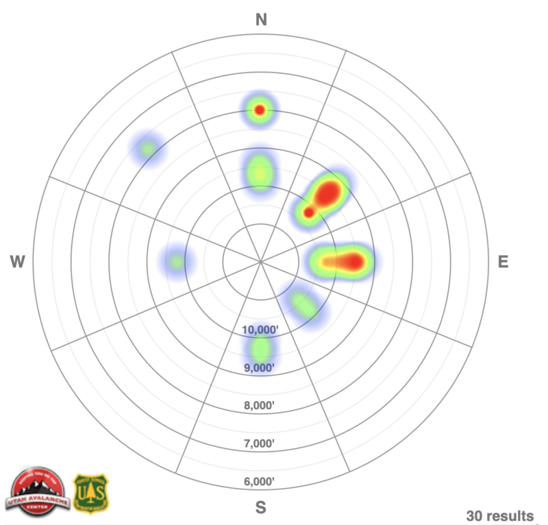
A Heat Map of aspect/elevation for these avalanches from Saturday Dec 2 through yesterday is below.
Avalanche Problem #2
Wind Drifted Snow
Type
Location
Likelihood
Size
Description
Elevated winds from the west and northwest along the highest elevations should keep you alert to unstable soft slabs of wind drifted snow in steep terrain. Avoid smooth rounded scallops of soft slab in the highest elevations today. They should start to stabilize over the next day or two.
Additional Information

Forecaster's Corner:
Idle Weather does the Devil's Work: Clear skies over the next several days will start to weaken the surface snow on the sun sheltered aspects, developing our potentially next weak layer.
UAC Education Coordinator McKinley Talty's haiku from fieldwork in Provo yesterday:
❄️
Poor structure afoot
Tipping point looming ahead
Where will you be then?
General Announcements
This information does not apply to developed ski areas or highways where avalanche control is normally done. This forecast is from the U.S.D.A. Forest Service, which is solely responsible for its content. This forecast describes general avalanche conditions and local variations always occur.