Discounted lift tickets - Thanks to the generous support of our Utah ski resorts and Ski Utah, all proceeds from these ticket sales go towards paying for avalanche forecasting and education! Get your tickets
here.
Yesterday had clouds stuck over many areas with just a trace to one inch of snow falling. Winds were mostly light through the day. This morning, winds at upper elevations are blowing 10-20 mph and gusting 20-40 mph from the W and NW. Temperatures are in the teens F without huge differences with elevation.
Today skies will be mostly cloudy with another chance for about an inch of snow. Winds will remain elevated compared to yesterday but will mostly be confined to upper elevations. Temperatures should climb into the 20s F.
Great riding conditions exist on most slopes. The powder is dense but fun, fast, and surfy on all aspects and elevations.
Making plans for this weekend? - Strong sunshine and very warm temperatures will make the snow wet on south aspects and low elevations. Get an early start if headed out on Saturday. Starting Sunday night going into Monday, very cold temperatures and decent snowfall arrive.
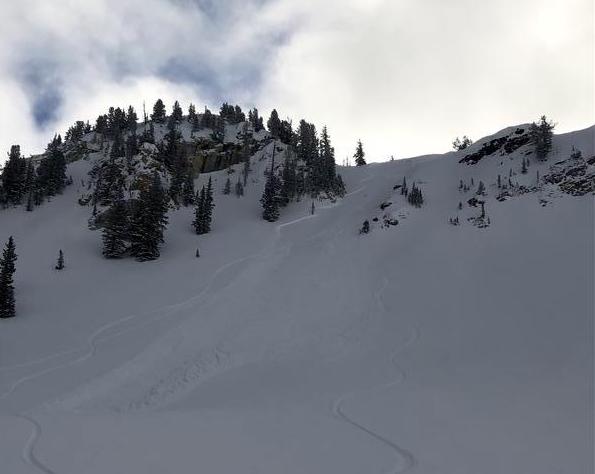
There were two reported avalanches yesterday. One was on
Little Superior on a south aspect about a foot deep that ran on top of a buried ice crust. Another was on a north aspect nearby in
Days Fork that was 18 inches deep and 200 feet wide.
On Tuesday similar slides were triggered on
Lake Peak,
Mt Tuscarora,
Mt Superior, and
Cardiff Peak. Many others were triggered on Monday. What these slides have in common is that they generally occurred at upper elevations above 9,500 feet. They have been 6-12 inches deep on both north and south aspects. Most have been less than 100 feet wide. See the full list of avalanche activity
HERE.
Ski areas have triggered similar soft slabs in recent days.
Photo - Avalanche in
Days Fork yesterday (Wed, Jan 29th).


