


Forecast for the Salt Lake Area Mountains

Friday morning, January 15, 2016
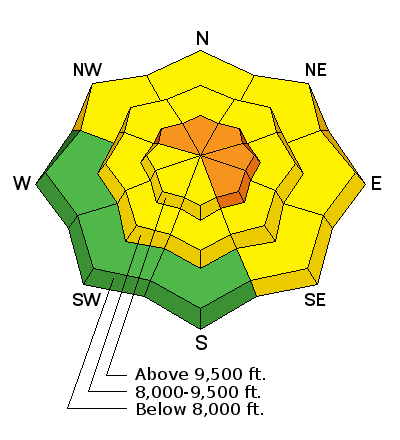
The Avalanche Danger is CONSIDERABLE on steep, wind-drifted slopes facing northwest through easterly at the upper elevations, above about 9,500’. Avoid travel on and below wind-drifted slopes, where avalanches can be triggered remotely. Other steep slopes have a MODERATE danger, and small loose sluffs will be easy to trigger on all aspects.
 Special Announcements
|
 Weather and Snow
Light to moderate snow is falling in the mountains this morning, and overnight totals are in the 3 to 7” range. Winds are from the southwest, slowly shifting to the west, and averaging 10 to 15 mph. Speeds across the highest ridge lines hit 30 mph overnight, but have decreased for the moment. Temperatures have warmed into the teens and low 20s.
Storm totals since midweek are now in the 6 to 8” range, with 8 to 14” in the Cottonwoods. It’s an excellent little refresher, nicely filling in old tracks.
 Recent Avalanches
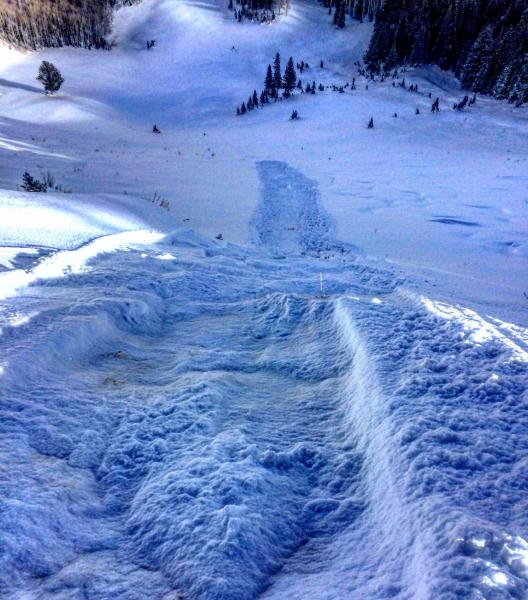
Yesterday in the backcountry, small sluffs and wind slabs were easily triggered – just large enough to catch and carry a person. They were on shady slopes, failing on the weak, faceted old snow surface. A few larger naturals occurred on northerly facing slopes in the upper elevation wind zone, around 11,000’.
Left: Sluffing, Mark White photo Right: Cracking in wind slabs

Wind Drifted Snow
Description
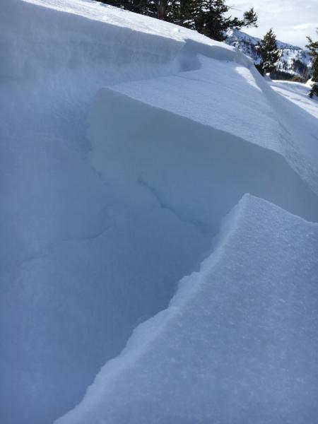
We finished off the high pressure with a layer of weak, faceted snow on the shady slopes, and have been slowly loading it with new snow.
Today, I think we will finally have a stiff enough slab in wind-affected terrain for avalanches to be easily triggered, and even a few natural slides to occur if the winds increase as forecast. On many slopes, the weakest old snow is in shallow snowpack areas, including slopes that slid early this winter. Slides can be remotely triggered from a distance today, pull back further than expected along the ridgelines, and run longer than average distances, entraining snow as they move down the hill. These slides will be large enough to bury a person.
Avalanche accidents often occur during periods of increasing danger. Winds are forecast to increase this afternoon, so be observant and ready to switch to wind sheltered terrain if speeds pick up where you are.
New Snow
Description
Even out of the wind-affected terrain, expect to trigger loose snow sluffs and small soft slabs on steep slopes of all aspects, including the sunny slopes. These will be new snow only, but still large enough to catch and carry a person. I still have thoughts about the deeper weak layers in the snowpack, but think today’s activity will be new snow only.
Additional Information
The small storm scooting through northern Utah this morning could drop another 2 to 5 inches of snow before it tapers off midday. 10,000’ temperatures will cool into the low teens by afternoon. The winds are slowly shifting to a more northwesterly direction, and may increase slightly, into the 20-25 mph range at 10,000’. There will be a break in the snowfall this afternoon through Saturday morning, followed by a small, warmer, windier storm Saturday evening into Sunday.
General Announcements
|
Remember your information can save lives. If you see anything we should know about, please participate in the creation of our own community avalanche advisory by submitting snow and avalanche conditions. You can also call us at 801-524-5304, email by clicking HERE, or include #utavy in your tweet or Instagram. To get help in an emergency (to launch a rescue) in the Wasatch, call 911. Be prepared to give your GPS coordinates or the run name. Dispatchers have a copy of the Wasatch Backcountry Ski map. Backcountry Emergencies. It outlines your step-by-step method in the event of a winter backcountry incident. If you trigger an avalanche in the backcountry, but no one is hurt and you do not need assistance, please notify the nearest ski area dispatch to avoid a needless response by rescue teams. Thanks. Salt Lake and Park City – Alta Central (801-742-2033), Canyons Resort/PCMR Dispatch (435)615-1911 Snowbasin Resort Dispatch (801-620-1017), Powder Mountain Dispatch (801-745-3772 x 123). Sundance Dispatch (801-223-4150) EMAIL ADVISORY If you would like to get the daily advisory by email you will need to subscribe here. DAWN PATROL Hotline updated daily by 5-530am - 888-999-4019 option 8. Twitter Updates for your mobile phone - DETAILS UDOT canyon closures: LINK TO UDOT, or on Twitter, follow @UDOTavy, @CanyonAlerts or @AltaCentral Utah Avalanche Center mobile app - Get your advisory on your iPhone along with great navigation and rescue tools. Powderbird Helicopter Skiing - Blog/itinerary for the day Lost or Found something in the backcountry? - http://nolofo.com/ To those skinning uphill at resorts: it is your responsibility to know the resort policy on uphill travel. You can see the uphill travel policy for each resort here. IMPORTANT: Before skinning or hiking at a resort under new snow conditions, check in with Ski Patrol. Resorts can restrict or cut off access if incompatible with control and grooming operations. Benefit the Utah Avalanche Center when you shop from Backcountry.com or REI: Click this link for Backcountry.com or this link to REI, shop, and they will donate a percent of your purchase price to the UAC. Both offer free shipping (with some conditions) so this costs you nothing! Benefit the Utah Avalanche Center when you buy or sell on ebay - set the Utah Avalanche Center as a favorite non-profit in your ebay account here and click on ebay gives when you buy or sell. You can choose to have your seller fees donated to the UAC, which doesn't cost you a penny. This information does not apply to developed ski areas or highways where avalanche control is normally done. This advisory is from the U.S.D.A. Forest Service, which is solely responsible for its content. This advisory describes general avalanche conditions and local variations always exist. |