Forecast for the Provo Area Mountains

Drew Hardesty
Issued by Drew Hardesty for
Thursday, April 14, 2022
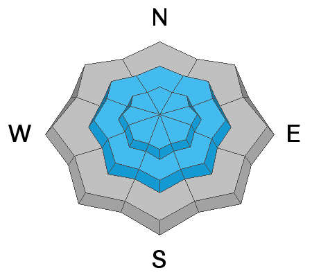
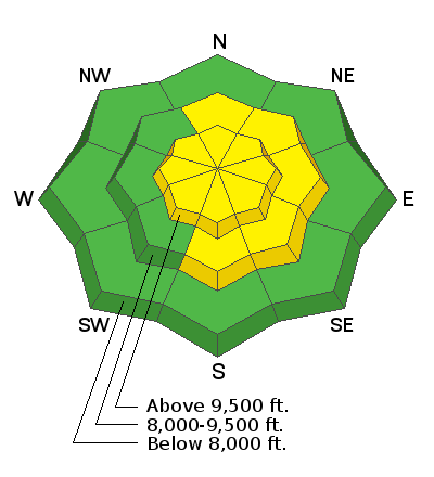
A MODERATE avalanche danger exists at the mid and upper elevations. Human triggered avalanches 6-18" deep are possible, particularly in areas with recent drifts of wind blown snow.
Follow safe travel protocol:
  • Make a plan.
  • One at a time.
  • Carry and know how to use your rescue equipment.

Cloud cover will be the WILD CARD. Any sun or greenhousing today will probably make WET AVALANCHES the primary concern.
Low
Moderate
Considerable
High
Extreme
Learn how to read the forecast here
Special Announcements
Our last regular forecast is Sunday, April 17th. Intermittent forecasts will be issued through April based upon weather conditions which affect avalanche danger.
Weather and Snow
"More January than January," is how Andy Van Houten described it yesterday: cold, snowy, blustery.
No snowfall was recorded overnight, but storm totals are up to 6-10"(0.6" SWE)

Skies are overcast with weak warm air advection kicking in another inch or two of snow this morning. Temperatures have followed suit, as many stations are at 24 hour highs in the low to mid-teens. Winds are west to southwest, blowing 15-20mph with gusts to 25.
For today, we'll see a few snow showers this morning with thinning cloud cover over the course of the day. Mountain temps will rise to the mid 20s up high, the mid 30s down low.
Skiing and riding conditions are fair to good. Coverage in the upper elevations sits at 50-70" but take caution that the late March warm-up burned many southerly aspects to dirt. Traumatic injury is possible with the thinly veiled stumps and rocks.

Another pulse of snow is expected this evening with 2-5" possible through tomorrow. It's not over.
--Do not go gentle into that good night,
Old age should burn and rave at close of day;
Rage, rage against the dying of the light
.--
A cold and windy storm is expected this weekend with unsettled weather on tap for the next week or so.
Recent Avalanches
We did not hear of any reports of activity.
Ad
Avalanche Problem #1
Wind Drifted Snow
Type
Location
Likelihood
Size
Description
Active wind transport at the mid and upper elevations has been noted over the past few days and drifts may still be triggered in steep wind loaded terrain. North to east to south facing aspects will hold most of the drifts, but terrain channeling will allow for wind drifts to be found around terrain features of all aspects.
Additional Information
THE WILD CARD: If the strong mid-April sun comes out for periods of time and/or is accompanied by intense greenhousing, WET AVALANCHES may become the primary concern. Direct sun will affect the solar aspects while greenhousing will rapidly affect the cold snow on all aspects, even the mid-elevation northerly aspects. YOU'LL NEED TO BE YOUR OWN FORECASTER to see how the sky cover affects the snow surfaces.
General Announcements
Who's up for some free avalanche training? Get a refresher, become better prepared for an upcoming avalanche class, or just boost your skills. Go to https://learn.kbyg.org/ and scroll down to Step 2 for a series of interactive online avalanche courses produced by the UAC.
This information does not apply to developed ski areas or highways where avalanche control is normally done. This forecast is from the U.S.D.A. Forest Service, which is solely responsible for its content. This forecast describes general avalanche conditions and local variations always occur.