UDOT PLANNED AVALANCHE CLOSURES!!

Forecast for the Provo Area Mountains

Nikki Champion
Issued by Nikki Champion on
Tuesday morning, March 4, 2025
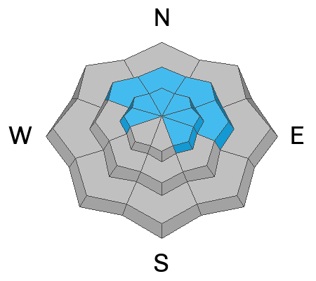
The avalanche danger is MODERATE across all upper-elevation slopes and mid-elevation slopes facing northwest through north and east, where elevated winds and new snow have created heightened avalanche conditions today. It remains possible to trigger a 2–4 foot deep avalanche on a persistent weak layer.
At lower elevations, where the snow has not undergone a solid refreeze, small wet snow avalanches remain a possibility.
Low
Moderate
Considerable
High
Extreme
Learn how to read the forecast here
Weather and Snow
This morning, the skies are overcast. Storm totals for the Provo-area mountains range from 1–3 inches of snowfall with 0.10–0.40 inches of water. Temperatures are in the upper 20s to low 30s °F. Winds have shifted to the west-northwest, averaging 5–15 mph with gusts up to 25 mph at mid-elevation ridgelines, and 20–30 mph gusting into the mid-30s to 40s at upper elevations.
Today, temperatures will rise into the upper 30s. Expect periods of snow this morning, turning partly cloudy with lingering snow showers in the afternoon. Winds will remain northwesterly, averaging 5–10 mph with gusts up to 20 mph at mid-elevations and 20–25 mph gusting to 35 mph at upper elevations. Daytime snowfall could add an additional trace to 2 inches.
The next storm, expected late Wednesday through Friday, looks promising, with 1.25 to 2.75 inches of water content, potentially bringing 14–30 inches of snow.
The range now holds a mix of snow surfaces beneath the new snow. South-facing and lower north-facing slopes likely have a stout crust, while upper north-facing terrain has recrystallized near-surface facets disguised as soft powder. With this storm, the new snow and wind slabs have prime bed surfaces across all aspects and elevations, making even light wind and snow enough to trigger long-running sluffs or sensitive slabs.
Recent Avalanches
Yesterday, there were no new reports of avalanches from the Provo area mountains.
Ad
Avalanche Problem #1
Wind Drifted Snow
Type
Location
Likelihood
Size
Description
Overnight, winds ramped up, with gusts hitting 50 mph at upper-elevation ridgelines. With some soft new snow available for transport, these strong winds may continue to form soft slabs of wind-drifted snow. As winds remain elevated throughout the day, expect these slabs to grow larger and more cohesive. While most pronounced on leeward slopes, such high winds can load any aspect as they swirl and shift through the terrain.
Approach steep terrain features where drifting snow has accumulated with caution. Watch for rounded, wavy, or pillowy snow, and be alert for signs of instability, such as cracking and collapsing.
Any new and wind-drifted snow is landing on ideal bed surfaces, making it prone to shallow but sensitive sluffs and slabs.
Avalanche Problem #2
Persistent Weak Layer
Type
Location
Likelihood
Size
Description
It’s still possible to trigger a 2–4 foot deep avalanche on a persistent weak layer, and the snowpack remains highly variable.
Snow depths vary significantly across the range. In some areas, the snowpack is deep and strong, measuring 6 feet or more, while slopes that have previously avalanched are much shallower—around 2–4 feet—with weak, faceted snow near the bottom. At one location, Dave Kelly observed full propagation, a sign that slab avalanches are still possible in certain terrain.
For now, probe and dig before committing to steep, north-facing terrain. Slopes that have recently avalanched are most likely to harbor weak layers, and steep, rocky terrain with shallow snowpacks remains a concern for weak, faceted snow.
It’s uncertain whether this storm will be enough to reactivate the persistent weak layer, but these slopes remain the most dangerous. Any additional loading from new snow and wind could tip the balance, and if the weak layer wakes up, avalanches in these areas will be large and destructive. Given the uncertainty, the safest move today is to avoid steep, shady terrain where these layers persist.
Avalanche Problem #3
New Snow
Type
Location
Likelihood
Size
Description
We should be mindful of how the new snow bonds to the underlying surfaces. Dry-loose avalanches are the primary concern today.
Watch for signs of instability, such as cracking and sluffing, as even a small slide can have serious consequences in steep terrain or near cliffs.
General Announcements
This information does not apply to developed ski areas or highways where avalanche control is normally done. This forecast is from the U.S.D.A. Forest Service, which is solely responsible for its content. This forecast describes general avalanche conditions and local variations always occur.