Forecast for the Provo Area Mountains

Trent Meisenheimer
Issued by Trent Meisenheimer for
Wednesday, March 23, 2022
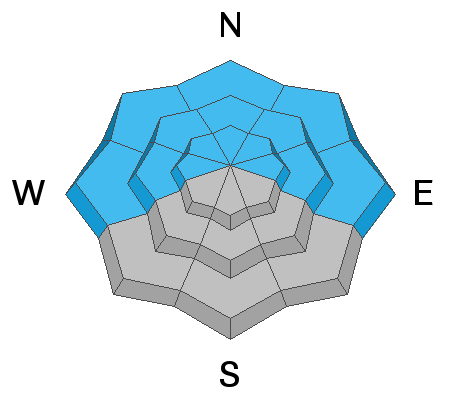
A MODERATE avalanche danger exists on steep west to north to east facing aspects at all elevations. Here, you can trigger avalanches 1-3' deep that fail on a persistent weak layer of faceted snow.
There is also a MODERATE avalanche danger on all aspects at the upper elevations for pockets of wind-drifted snow.
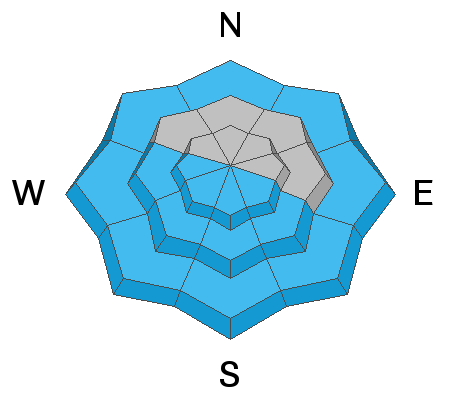
On steep southerly facing terrain, and low elevation northerly terrain the avalanche danger will rise to MODERATE for wet-loose avalanches as mountain temperatures warm during the day.
Low
Moderate
Considerable
High
Extreme
Learn how to read the forecast here
Special Announcements
Please help support avalanche forecasting throughout Utah. Donate to the Spring Campaign to help raise the funds to support the forecasting you rely on.
Weather and Snow
Warm air advection and high pressure (ridging) will dominate the weather pattern for the next week with plenty of sunshine and mountain temperatures skyrocketing to 46 °F at 700 millibars (10,000') this weekend. The Salt Lake City valley is forecast to reach 79 °F on Saturday with a 55% chance of setting a new high-temperature record. On Sunday it gets better with an 82% chance of either beating or tying the high-temperature record. Many places across the Beehive State are slated for record-breaking temperatures.
For today, enjoy the cool breeze while it lasts. Current mountain temperatures range from 20-28 °F. Winds will be from the northwest and blow 5-15 mph across the upper elevation terrain. Mountain temperatures will climb into the upper 40's to low 50's °F this afternoon at Aspen Grove. Cold dry powder still exists in the mid to upper elevation northerly terrain. However, the powder compass will be shrinking more and more over the next few days.
Recent Avalanches
No new observations from the Provo area. Two observations came through overnight in the central Wasatch. The first was a very honest report on a small catch and carry-on Little Superior from Monday. The second was in the Y-Couloir where wet snow buried their boot-pack.
Ad
Avalanche Problem #1
Persistent Weak Layer
Type
Location
Likelihood
Size
Description
Triggering avalanches 1-3' deep on steep slopes facing west through north and east at all elevations remains possible. These avalanches are failing on a persistent weak layer (PWL) that formed during the January/February drought.
Many of these avalanches are being triggered at the mid-elevations (8,000' - 9,500') and often in slight openings in otherwise dense trees. We've had many close calls throughout March on this weak layer and it's not time to let our guard down. My strategy is to avoid steep slopes steeper than 30° where there is faceted snow buried.
Avalanche Problem #2
Wind Drifted Snow
Type
Location
Likelihood
Size
Description
You may continue to find pockets of sensitive wind-drifted snow at the upper elevations. These fresh wind drifts may run long distances on slopes with smooth crusts underneath. These wind slabs are roughly 12-24" deep and up to 70' wide. As always, look for and avoid slopes that look rounded and pillowy.
Avalanche Problem #3
Wet Snow
Type
Location
Likelihood
Size
Description
Overnight temperatures dropped well below freezing allowing the snow surface to once again completely freeze this morning. However, if you notice the snow surface becoming damp or unsupportable or see active roller balls cascading down, it's time to head home or change your aspect.
Pay attention to steep northerly facing terrain at the low elevations and see if the snow is becoming wet or damp. Yesterday in the Y-Couloir their boot-pack lower down was completely taken out by wet avalanches.
General Announcements
Who's up for some free avalanche training? Get a refresher, become better prepared for an upcoming avalanche class, or just boost your skills. Go to https://learn.kbyg.org/ and scroll down to Step 2 for a series of interactive online avalanche courses produced by the UAC.
This information does not apply to developed ski areas or highways where avalanche control is normally done. This forecast is from the U.S.D.A. Forest Service, which is solely responsible for its content. This forecast describes general avalanche conditions and local variations always occur.