Forecast for the Provo Area Mountains

Trent Meisenheimer
Issued by Trent Meisenheimer for
Tuesday, March 15, 2022
Areas of CONSIDERABLE avalanche danger exist on steep aspects facing west to north to east at all elevations. Avalanches may be 2-4' deep, well over a hundred feet wide, and maybe triggered remotely (from a distance).
A MODERATE danger exists across the upper elevations for shallow wind drifted snow avalanches. As always, look for and avoid the snow that is wavey, rounded and pillowy.
Low
Moderate
Considerable
High
Extreme
Learn how to read the forecast here
Weather and Snow
Under clear skies, the mountain temperatures range from 24 °F in the valley bottoms and roughly 33 °F at the Bunnell's site at 8,880'. Winds did pick up just a little overnight and are currently blowing from the west-southwest at speeds of 10-15 mph across the upper elevations.
Mountain temperatures will warm into 30's and low 40's °F today ahead of an approaching storm. Southwest winds are forecast to increase to speeds of 15-25 mph across the upper elevation terrain. Clear skies will eventually give way to partly to completely cloudy skies later this afternoon into this evening. We should begin to see snowfall across northern Utah by the dinner hour. Light snow will last through Wednesday. It's a small storm, and hopefully, we see 2-5" of new snow when it's all done.
It's spring, and the weather can turn on a dime. Be sure to pay attention to changing conditions, i.e., " Green Housing" or strong bands of snow (precipitation intensity). Both of these weather events usually spike avalanche activity.
Recent Avalanches
No new observations from the Provo area. In the central Wasatch, an experienced group triggered a very large avalanche in Big Cottonwood Canyon in Mineral Fork on Barrieto. The avalanche was skier-triggered when they dropped in for a slope cut. The skier triggered the slab, and it propagated 600 feet wide 2-4 feet deep and ran 1600 vertical feet to the bottom, crossing the creek and traveling up the other side of the drainage. Luckily, nobody was caught in this beast of an avalanche.
Photo: Barrieto avalanche. Northeast facing slope at 9,981 feet in elevation, failing on a persistent weak layer.
Ad
Avalanche Problem #1
Persistent Weak Layer
Type
Location
Likelihood
Size
Description
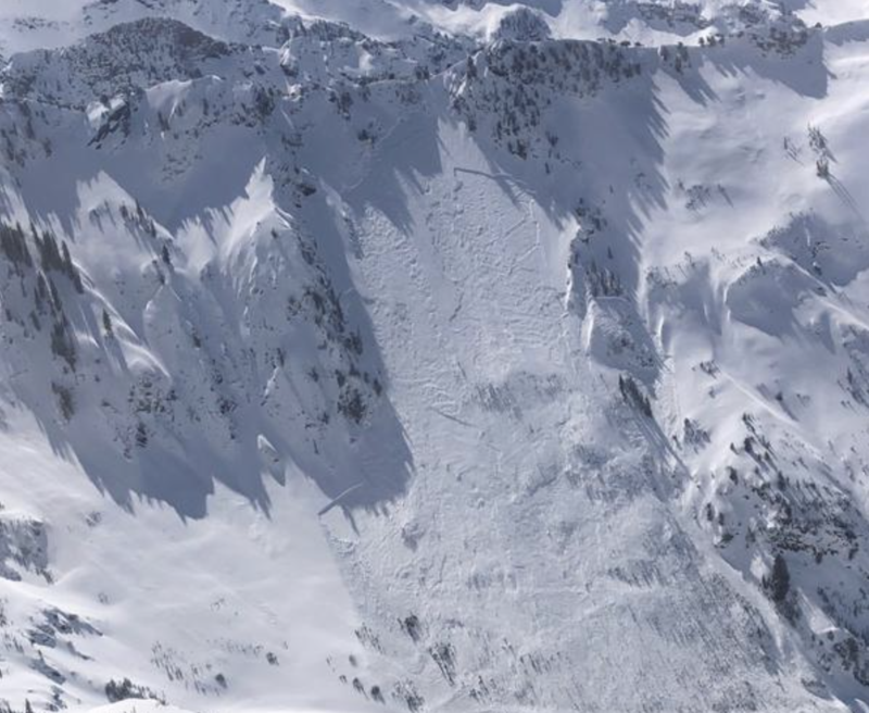
Many large and dangerous human-triggered avalanches have occurred over the past several days, failing on a layer of faceted snow (a persistent weak layer) that formed during the January/February drought. Avalanches failing on this weak layer are 2-4' deep and well over 100' wide and can easily catch, carry, bury, and kill a human. These avalanches are not to be messed with.
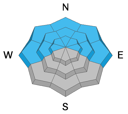
If yesterday's avalanche in Mineral Fork isn't enough to convince you to back off, I am unsure what will? I know that I will continue to avoid being on or below steep avalanche terrain (slopes steeper than 30°) on the north side of the compass for the time being. I have zero confidence in the snowpack right now. There are no secrets here; it's plain dangerous. Avalanche professionals and people with years of experience are simply avoiding this type of terrain.
Persistent weak layers can be triggered remotely, from a distance, or from below. Imagine walking up to a giant log pile and pulling out the bottom log, and having the entire log pile come crashing down on top of you.
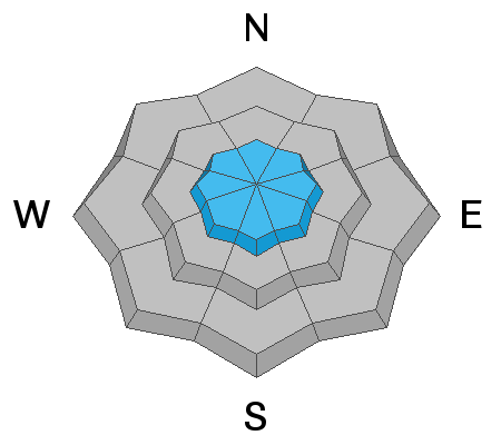
Yesterday south-facing slopes were the ticket, and unfortunately, today, they will be sun-crusted and less appealing. This will force us into the northerly facing terrain where the snow is soft and therefore luring us into the avalanche dragon's den. Don't be fooled when there are no obvious clues to an unstable snowpack, i.e., cracking & collapsing. Tracks are not an indicator of stability.
Avalanche Problem #2
Wind Drifted Snow
Type
Location
Likelihood
Size
Description
Southerly winds have increased and will continue to increase throughout the day today. There is plenty of new snow for the wind to deposit fresh drifts of wind-blown snow on leeward slopes at the upper elevations. As always, be on the lookout and avoid the snow that looks rounded and pillowy. On northerly facing terrain: any wind slab you may trigger has the potential to step down into our persistent weak layer, triggering a much larger avalanche.
General Announcements
Who's up for some free avalanche training? Get a refresher, become better prepared for an upcoming avalanche class, or just boost your skills. Go to https://learn.kbyg.org/ and scroll down to Step 2 for a series of interactive online avalanche courses produced by the UAC.
This information does not apply to developed ski areas or highways where avalanche control is normally done. This forecast is from the U.S.D.A. Forest Service, which is solely responsible for its content. This forecast describes general avalanche conditions and local variations always occur.