Forecast for the Provo Area Mountains

Trent Meisenheimer
Issued by Trent Meisenheimer on
Saturday morning, February 8, 2025
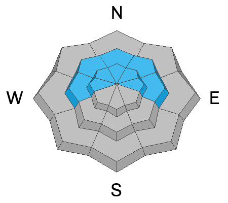
The avalanche danger is CONSIDERABLE on mid and upper-elevation steep slopes facing west to north to east for slab avalanches. Here, avalanches can fail within the new snow or at the old/new snow interface. On northerly facing terrain, these avalanches could step down into buried weak layers of faceted snow, making them more dangerous. Human-triggered avalanches 1 to 3 feet deep are likely today.

On slopes without weak faceted snow, there is a MODERATE danger for new snow and wind-drifted snow avalanches.
Low
Moderate
Considerable
High
Extreme
Learn how to read the forecast here
Weather and Snow
The storm started out of the south with strong winds and plenty of graupel snow (round pellets). Around 2:00 PM, the cold front pushed through, the winds diminished, and temperatures dropped. 24-hour storm totals range from 2 to 8 inches of new snow containing 0.22 to 0.83 inches of water.
This morning, the wind blows from the west at speeds of 5-10 mph with gusts into the 20s across the upper elevations. Mountain temperatures range from 10 to 20 °F. This afternoon, clouds will increase, and we will see the winds switch back to the west-southwest and blow 10-15 mph with gusts into the 20s as a small storm moves in late this afternoon. This storm could bring a couple more inches of snow, and temperatures will climb into the mid-20s.
Recent Avalanches
No new avalanche activity was reported yesterday.
Ad
Avalanche Problem #1
New Snow
Type
Location
Likelihood
Size
Description
With 2 to 8 inches of new snow, it's hard to know precisely how touchy the new snow will be this morning. Today we could see avalanches fail within the new snow or at the new/old snow interface. We could also see avalanches step down into our January buried facets making these deeper and more dangerous (see pwl).
Provo has an exceptionally weak snowpack, and I am unsure what it will take to cause avalanches. But it can't be much. Use test slopes, slope cuts, and shovel tilt tests to see how this new snow is behaving.
Avalanche Problem #2
Wind Drifted Snow
Type
Location
Likelihood
Size
Description
Northern Utah has seen strong wind for over a week now, and yesterday's pre-frontal southwest wind was no exception. The new snow will have buried old hard drifts and formed new soft slabs of wind-blown snow across the mid and upper elevations. Any fresh wind drift may fail at the existing snow surface or on slopes facing west through east; they could step down 1-3 feet deep into buried weak layers of faceted snow.
Avalanche Problem #3
Persistent Weak Layer
Type
Location
Likelihood
Size
Description
There are two buried persistent weak layers (PWL) in the snowpack:
1. The upper layer buried down 12-24 inches formed during cold, clear weather in late January and has been buried by recent storms and wind-drifted snow. Today, this layer could become active with the additional water weight we have added in the past 24 hours. Avalanches 1 to 3 feet deep are possible.
2. The lower layer, near the ground, formed in December and has caused large avalanches, including two fatalities during the Holiday Avalanche Cycle.. This layer is most problematic in steep rocky terrain or on repeater slopes that previously avalanched this winter.
General Announcements
This information does not apply to developed ski areas or highways where avalanche control is normally done. This forecast is from the U.S.D.A. Forest Service, which is solely responsible for its content. This forecast describes general avalanche conditions and local variations always occur.