Forecast for the Provo Area Mountains

Trent Meisenheimer
Issued by Trent Meisenheimer on
Wednesday morning, February 14, 2024
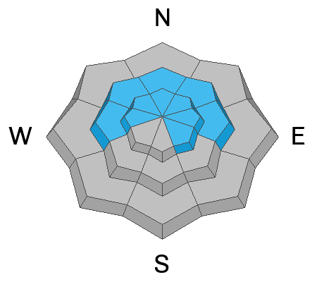
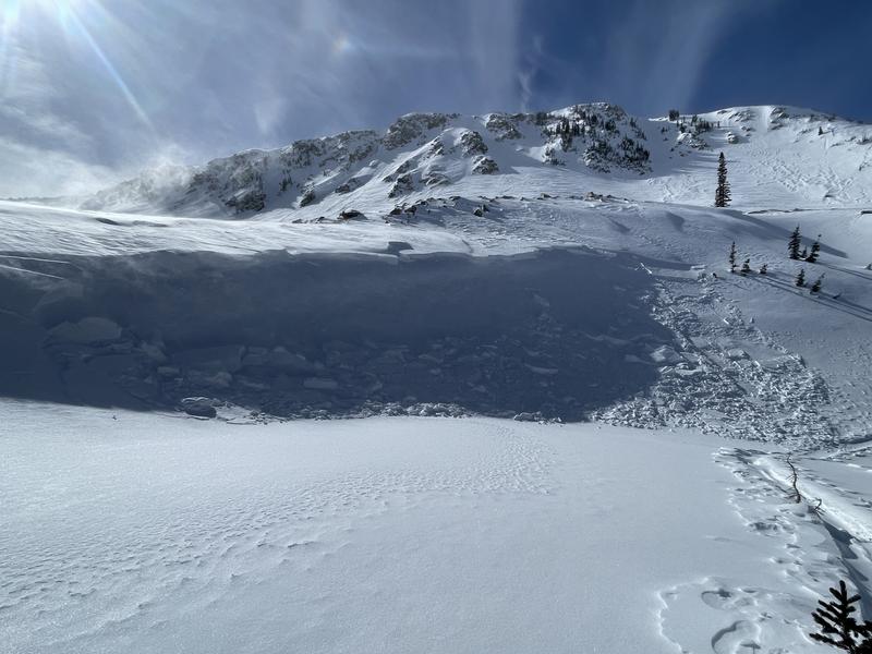
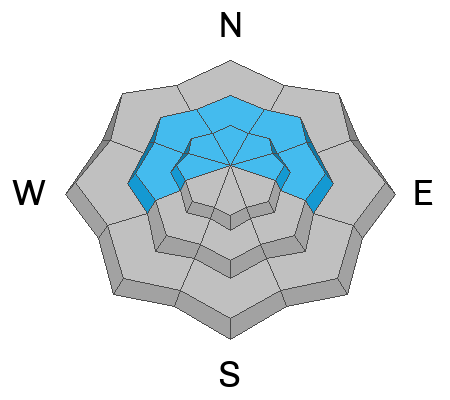
Today, the avalanche danger is MODERATE on mid and upper-elevation slopes facing west through north through east, where it is possible to trigger a hard slab avalanche breaking 4-6' deep on buried faceted snow. There is also a MODERATE avalanche danger for shallow soft or hard slabs of wind-drifted snow. These drifts may be 6-12 inches deep and up to 100 feet wide.
Evaluate the snow and terrain carefully; identify and avoid areas of concern. Human-triggered avalanches are possible today.
Low
Moderate
Considerable
High
Extreme
Learn how to read the forecast here
Weather and Snow
Overnight, the mountains picked up 1-2 inches of new snow (0.07" water). This morning, it's lightly snowing in some areas, with mountain temperatures ranging from 20-25 °F. Winds are blowing from the south-southwest at 15-20 mph, with gusts almost to 30 mph.
As this small storm exits and moves to the east, we should see snow showers throughout the morning hours before turning partly cloudy this afternoon with some sunshine. Temperatures will climb into the low to mid-30s °F. The wind is forecast to change to the southwest and increase in speed. Upper elevation ridgelines will see southerly wind blow 15-25 mph with gusts into the 30s and 40s ahead of another storm slated to arrive overnight into Thursday.
Thursday's storm will bring 7-14 inches of snow by the weekend. After that, a large closed low sets up off the California Coast and looks to park there for a few days. This closed low will usher in a moist southwest flow and, depending on where the waves of moisture hit, will determine how much snow we get.
Recent Avalanches
Yesterday, no new avalanche activity was reported. However, Bo Torry sent in a nice photo of a recent large avalanche off Cascade Ridge. This past weekend, we had several close calls and very large avalanches. Read and click through the following: Lisa Falls / Pioneer Ridge / Main Gobblers / Cardiac Ridge / Pole Canyon. There have been 16 avalanches reported since the weekend, and you can find that list HERE.
Ad
Avalanche Problem #1
Wind Drifted Snow
Type
Location
Likelihood
Size
Description
Yesterday's prefrontal wind from the southwest blew for roughly 12 hrs at elevated speeds. Today we will see another increase in southerly wind. This wind, and plenty of soft snow available to transport, has dotted the landscape with small hard and soft slabs of wind-drifted snow. These wind slabs could be 6-12 inches deep and up to 100' wide (picture below).
Yesterday in my travels, I noted very weak surface snow from our few clear and cold nights. I suspect some wind-drifted snow will avalanche or be remotely triggered because it formed over surface hoar or small-grained faceted snow. Therefore, be on the lookout for wind-drifted snow and be sure to avoid those areas. The challenging part will be the 1-2 inches of new snow that now covers yesterday's wind slabs making them visually hard to see.
Avalanche Problem #2
Persistent Weak Layer
Type
Location
Likelihood
Size
Description
This avalanche problem remains a concern, particularly in the most suspect areas: steep, shallow, and rocky terrain features or shallow areas that have previously avalanched this season. If you trigger this layer, it's likely to break 4-6 feet deep into dry faceted snow. As we saw over the weekend, these avalanches may be hundreds of feet wide, run thousands of vertical feet downhill, and are likely unsurvivable.
General Announcements
This information does not apply to developed ski areas or highways where avalanche control is normally done. This forecast is from the U.S.D.A. Forest Service, which is solely responsible for its content. This forecast describes general avalanche conditions and local variations always occur.