Forecast for the Provo Area Mountains

Mark Staples
Issued by Mark Staples on
Tuesday morning, December 3, 2019
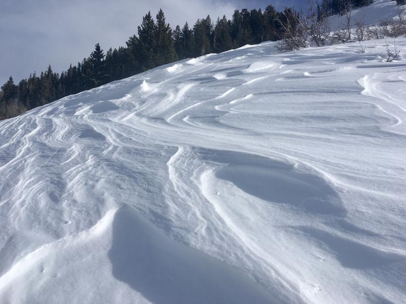
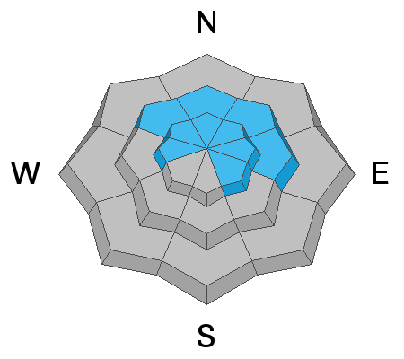
The avalanche danger is CONSIDERABLE on most upper elevation slopes facing the northern half of the compass including west and east and southeast ALSO on mid-elevation slopes facing northwest through north through east. All other mid and upper elevation slopes have a MODERATE danger. Low elevation slopes below 8000 feet have a LOW avalanche danger.
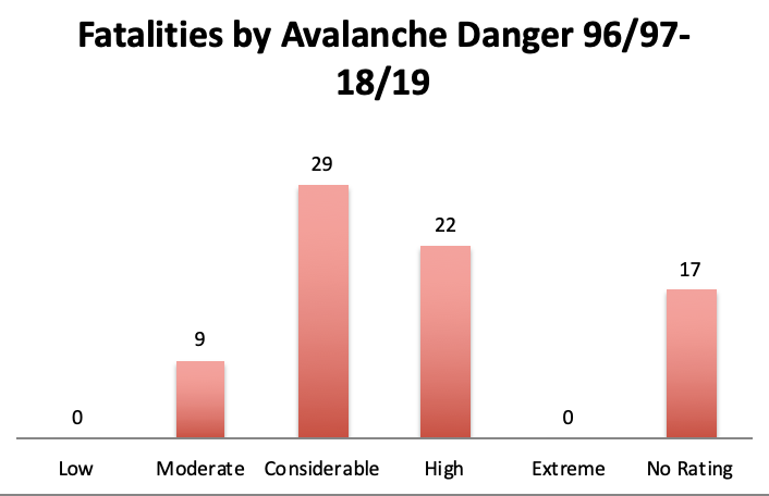
The definition of considerable avalanche danger is dangerous avalanche conditions. Last weekend following the storms over the Thanksgiving week, many slopes were "hair trigger" and produced avalanches as people simply approached those slopes. Today, the sensitivity has gone down, but there is still a very good chance you can trigger a large, deadly avalanche.
Low
Moderate
Considerable
High
Extreme
Learn how to read the forecast here
Special Announcements
The first UAC podcast of the season " Early Season Essentials with Program Director Bo Torrey" check it out HERE.

Get one of these cool t-shirts to support the UAC and other avalanche centers across the U.S.
Weather and Snow
Scroll to the bottom for a summary of area snowfall totals.
This morning temperatures are generally in the upper 20s and low 30s F following high temperatures yesterday near 40 degrees F. Sunday and Monday had strong southerly winds which had become westerly this morning and were blowing 5-10 mph. At upper elevations. they were blowing 30 mph.
Total snow depths are generally 2-3 feet.
The combination of warm temperatures, sunshine, and southerly winds has made good powder on south and west-facing slopes hard to find. The photo below (Grainger) shows scouring from recent winds. Note - winds in the photo were blowing right to left.

For today, high level clouds should build this afternoon. Temperatures should warm into the upper 20s and low 30s F. Winds shouldn't change much from where they are this morning. Some snow may arrive Wednesday afternooon or evening.
Recent Avalanches
No recent avalanches have been reported in the Provo mountains. This does not mean they didn't occur during the Thanksgiving storm; it just means they weren't observed or reported.
Ad
Avalanche Problem #1
Persistent Weak Layer
Type
Location
Likelihood
Size
Description
Decision making for me is really simple. I would stay off any slope that held old snow prior to last week. This old snow formed a persistent weak layer of facets at the ground. Snowfall last week overloaded this weak layer and produced a widespread avalanche cycle in the Central Wasatch. A soft slab 2-3 feet thick rest on this weak layer now. The diagram or "rose" shows where this persistent weak layer exists by aspect and elevation - slopes above 9500 feet facing W, NW, N, NE, E, and SE north, & slopes between 8000 and 9500 feet facing NW, N, NE, and E.
Triggering an avalanche on this weak layer remains likely. The resulting avalanche would be 2-3 feet deep (or more on wind loaded slopes) and would break hundreds of feet wide. Unfortunately, this avalanche problem is here to stay. Through time it may become more stubborn to trigger but the threat will remain. Sunday/Monday's southerly winds drifted snow and provided additional loading to many of these slopes. More load = more stress = avalanches.
The only way to avoid this problem is to ride slopes less than 30 degrees in steepness which aren't steep enough to slide. Also, avoid being under any steep slope because you could still trigger these avalanches from below and have one crash down on you. View a simulation of how this happens HERE.
Avalanche Problem #2
Wind Drifted Snow
Type
Location
Likelihood
Size
Description
Recent southerly winds transported snow and formed slabs of wind drifted snow. These wind slabs should be less sensitive today EXCEPT where they will be very easy to trigger where they sit on top of a persistent weak layer of facets.
Basically, I'd avoid any slope that appears to have wind drifted snow. Read more about how to identify fresh wind drifts HERE.
Additional Information
Total snow since Monday the 25th is:
Wasatch Mountains: 50-70" snow (3.5 - 4.34" h20)
Park City Ridgline: 30-40" snow (2.5 - 3.0" h20)
Ogden Mountains: 40-50" snow (4.0 - 4.8" h20)
Provo Mountains: 24-33" snow (1.6 - 2.1" h20)

Most avalanche accidents and fatalities occur during CONSIDERABLE danger.
Why? Often, it's because the signs of instability are not as evident as they were only a day or two before.
General Announcements
This information does not apply to developed ski areas or highways where avalanche control is normally done. This forecast is from the U.S.D.A. Forest Service, which is solely responsible for its content. This forecast describes general avalanche conditions and local variations always occur.
Remember your information can save lives. If you see anything we should know about, please help us out by submitting snow and avalanche conditions. You can also call us at 801-524-5304, email by clicking HERE, or include #utavy in your tweet or Instagram.
To get help in an emergency (to request a rescue) in the Wasatch, call 911. Be prepared to give your GPS coordinates or the run name. Dispatchers have a copy of the Wasatch Backcountry Ski map.
Backcountry Emergencies. It outlines your step-by-step method in the event of a winter backcountry incident.
If you trigger an avalanche in the backcountry, but no one is hurt and you do not need assistance, please notify the nearest ski area dispatch to avoid a needless response by rescue teams. Thanks.
  • Salt Lake and Park City – Alta Central (801-742-2033), Canyons Resort/PCMR Dispatch (435-615-1911)
  • Ogden - Snowbasin Resort Dispatch (801-620-1017), Powder Mountain Dispatch (801-745-3772 x 123)
  • Provo - Sundance Dispatch (801-223-4150)