Forecast for the Provo Area Mountains

Thursday morning, November 27, 2014
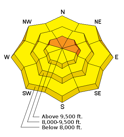
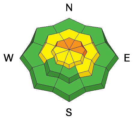
The avalanche danger remains CONSIDERABLE in the upper elevation northwest through east facing slopes that are steeper than about 35 degrees above around 9500 feet. Human triggered avalanches in this terrain are again likely today. People with limited knowledge of avalanche assessment should use extra caution today. Those with good skills know the drill.

 Weather and Snow
Temperatures have been on the rise for the last 48 hours and are currently 30 to 40 degrees at most mountain locations. Winds have decreased into the moderate speed range from the west. Snow observations from Wednesday included wet snow below around 8000 feet and on the more sunny aspects. Riding conditions were reported as good.
 Recent Avalanches
Snow safety teams in Provo Canyon noted one slab avalanche that released naturally in Slide Canyon sometime late Tuesday night during the wind event. There was no other activity reported although access into the high terrain is limited by lack of snow at lower elevations. There were numerous avalanches reported in the Salt Lake region. Check under "Detailed Information" for specifics.
New Snow

Description
It should be apparent that the weak snow near the ground is still active and a big concern. It's easy to assess the snowpack when the signs are obvious like collapsing or "whoomping" underfoot and when we remotely trigger avalanches. But now we will start to slide into a difficult period where the signs won't be so obvious. As settlement occurs, collapsing of the snowpack will not be so common. We won't be remotely triggering avalanches. They will wait until we are well onto the slope before releasing. So, no obvious signs of instability is not a green light. Also keep in mind that if you are traveling where others have already traveled, it is likely they have already collapsed the snowpack and you probably won't experience that. Poor snowpack structure is the trump card right now.
Wet Snow

Description
Potential minor wet avalanche activity is hardly a concern next to the persistent slab issue but pay attention to slopes that become really wet today. There is a slight chance that temperatures warm enough to trigger a natural persistent slab avalanche through accelerated creep rates today also.
Additional Information
We'll see high thin clouds with mild temperatures and moderate speed west winds today. Anticipate unseasonably warm temperatures today. High pressure stays in place into the weekend with low confidence in potential storms following. We'll have warm temperature again Friday and perhaps into Saturday and it looks slightly breezy as well. The EC and GFS weather models have drastically different scenarios for late in the weekend and into next week with the GFS showing better chances for storms.
General Announcements
Remember your information can save lives. If you see anything we should know about, please participate in the creation of our own community avalanche advisory by submitting snow and avalanche conditions. You can also call us at 801-524-5304, email by clicking HERE, or include #utavy in your tweet or Instagram.
If you trigger an avalanche in the backcountry - especially if you are adjacent to a ski area – please call the following teams to alert them to the slide and whether anyone is missing or not. Rescue teams can be exposed to significant hazard when responding to avalanches, and do not want to do so when unneeded. Thanks.
Salt Lake and Park City – Alta Central (801-742-2033), Canyons Resort Dispatch (435-615-3322)
Snowbasin Resort Dispatch (801-620-1017), Powder Mountain Dispatch (801-745-3772 x 123).
Sundance Dispatch (801-223-4150)
EMAIL ADVISORY If you would like to get the daily advisory by email you will need to subscribe here.
DAWN PATROL Hotline updated daily by 5-530am - 888-999-4019 option 8.
Twitter Updates for your mobile phone - DETAILS
UDOT canyon closures: LINK TO UDOT
Utah Avalanche Center mobile app - Get your advisory on your iPhone along with great navigation and rescue tools.
Wasatch Powderbird Guides Blog/Itinerary for the Day.
Lost or Found something in the backcountry? - http://nolofo.com/
Discount lift tickets will soon be available at Backcountry.com - Thanks to Ski Utah and the Utah Resorts. All proceeds go towards paying for Utah Avalanche Center avalanche and mountain weather advisories.
To those skinning uphill at resorts: it is your responsibility to know the resort policy on uphill travel. You can see the uphill travel policy for each resort here. IMPORTANT: Before skinning or hiking at a resort under new snow conditions, check in with Ski Patrol. Resorts can restrict or cut off access if incompatible with control and grooming operations.
Benefit the Utah Avalanche Center when you shop from Backcountry.com or REI: Click this link for Backcountry.com or this link to REI, shop, and they will donate a percent of your purchase price to the UAC. Both offer free shipping (with some conditions) so this costs you nothing!
Benefit the Utah Avalanche Center when you buy or sell on ebay - set the Utah Avalanche Center as a favorite non-profit in your ebay account here and click on ebay gives when you buy or sell. You can choose to have your seller fees donated to the UAC, which doesn't cost you a penny.
This information does not apply to developed ski areas or highways where avalanche control is normally done. This advisory is from the U.S.D.A. Forest Service, which is solely responsible for its content. This advisory describes general avalanche conditions and local variations always exist.


