Forecast for the Provo Area Mountains

Mark Staples
Issued by Mark Staples on
Friday morning, January 10, 2020
Today, Upper and mid-elevations have a MODERATE danger, and low elevations with less snow and less wind have a LOW avalanche danger.
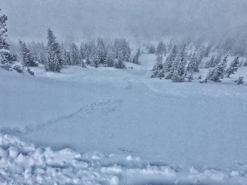
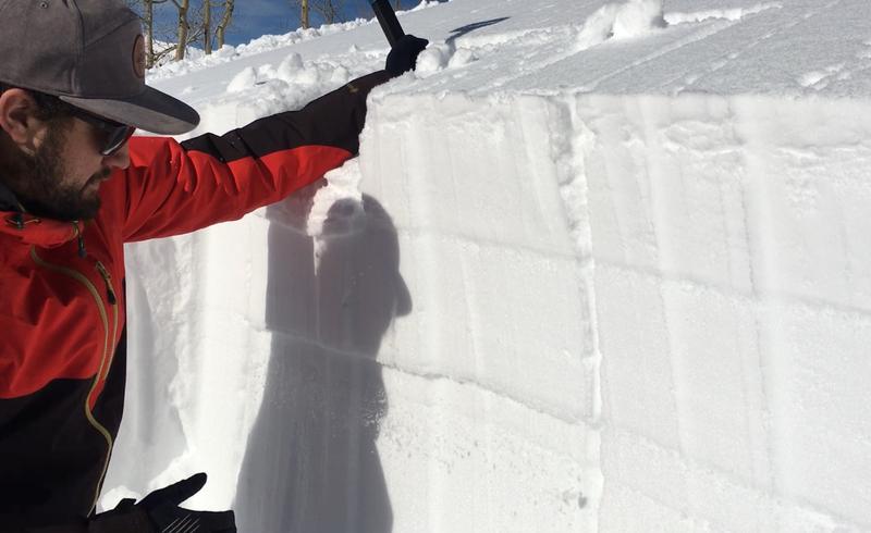
There are three avalanche problems to watch for: (1) soft slabs of wind drifted snow, (2) deeper slabs about 2-3 feet deep breaking near an ice crust on southerly facing slopes, and (3) sluffing within the new snow.

Here's the thing - the danger can vary widely. Any wind loaded slope will be more likely to produce an avalanche than a non-wind loaded slope. Southerly facing slopes with an ice crust/weak layer combo about three feet deep will be more dangerous that slopes without this layer (read more below). The danger ratings reflect general trends.
Low
Moderate
Considerable
High
Extreme
Learn how to read the forecast here
Special Announcements
Get discount lift tickets HERE. Thanks for this generous support from Utah Ski Resorts and Ski Utah. All proceeds go directly to supporting the UAC.
Weather and Snow
Since yesterday morning, another 3-6 inches of snow has fallen. This snow fell on top of 1-3 inches that fell yesterday. Total water amounts in the last 48 hours are generally about 0.25 inches.
Winds increased early this morning and are averaging 10-15 mph and gusting 20-30 mph at ridgetops from the WNW. A few lower elevation sites are showing gusty winds around 20 mph.
Temperatures are hovering near 10 degrees F.
Today snowfall should be winding down as I'm writing this. Winds will slowly trend downward but will remain somewhat strong this morning from the WNW. Skies should clear today and become sunny but temperatures may only warm into the mid 20s F. More snow returns Saturday morning. See the graphic from the National Weather Service at the bottom of the page.
Recent Avalanches
Yesterday observers in the backcountry mainly found low-density snow that would sluff but had not become a slab. Ski areas found mostly small avalanches confined to ridgelines.
Previous avalanche activity that concerns me occurred on southerly facing slopes. These avalanches broke on a weak layer near an ice crust now buried about 3 feet deep. The most recent one occurred on Tuesday.
Photo - sluffing in the new snow observed yesterday in Silver Fork of Big Cottonwood Canyon (Fink).
A full list of recent avalanches and observations can be found HERE.
Ad
Avalanche Problem #1
Wind Drifted Snow
Type
Location
Likelihood
Size
Description
Increased winds this morning will easily transport the new snow and form soft slabs of wind drifted snow. The new snow has a density of 4% which is about as light as it gets and even the slightest wind can move this snow. These soft wind slabs should easily produce avalanches today because they are resting on very low density snow which will be the weak layer on which they will fracture.
Look for wind drifted snow on all aspects above 8000 feet which is the mid and upper elevations. Sometimes slopes are loaded by winds from the top or sometimes they are loaded from winds blowing across slopes. The good news about this avalanche problem is that it is easy to identify visually.
Avalanche Problem #2
Persistent Weak Layer
Type
Location
Likelihood
Size
Description
Many human triggered avalanches occurred on January 4th on southerly aspects. They were soft slabs 1-2 feet deep breaking on a weak layer next to an ice crust (see photo below) that formed just before New Years. New snow over the last 48 hours has not stressed this layer too much. To be honest, I don't know if avalanches will occur on this layer today, but we have to assume they will for now.
Yesterday, I rode in the mountains above Bountiful (video) and was shocked to find a weak layer that formed just before New Years on ALL ASPECTS. We dug over half a dozen snowpits at elevations between 8-9000 feet and got the same unstable results in all places. This told me two things. (1) If riding in these mountains, the additional snow overnight and more coming this weekend will stress this layer and should cause deeper avalanches. (2) It will be worth looking for this layer on all aspects in other mountains.
What to do today? First, I would avoid steep southerly facing slopes where this layer most likely exists. Second, before committing to a steep north, east, or west facing slope, I would dig 3 feet deep and perform an Extended Column Test (ECT) on a small slope or a low angle slope with a similar aspect and elevation to the slope you hope to ride. If the ECT fractures across the entire column, that is bad and I would not ride the slope. Let us know what you find.
Avalanche Problem #3
New Snow
Type
Location
Likelihood
Size
Description
The new snow was easily sluffing yesterday. With more very light snow falling overnight, it should sluff easily today. These sluffs typically break at your feet and are not a major concern. However, watch for terrain traps like gullies or creeks where sluffs can pile up deeper.
Additional Information
General Announcements
This information does not apply to developed ski areas or highways where avalanche control is normally done. This forecast is from the U.S.D.A. Forest Service, which is solely responsible for its content. This forecast describes general avalanche conditions and local variations always occur.