Forecast for the Provo Area Mountains

Dave Kelly
Issued by Dave Kelly for
Monday, January 1, 2024
Happy New Year. Today there is a LOW avalanche danger where natural and human triggered avalanches are unlikely except in isolated areas or extreme terrain.
Low
Moderate
Considerable
High
Extreme
Learn how to read the forecast here
Weather and Snow
Under clear skies trailhead temperatures are in the mid to high 20's°F. Winds are blowing lightly at all mountain locations this morning. There was no new snow reported overnight and snow heights range from 1-3' with isolated areas holding close to 4' of snow.
For today, winds will blow lightly from the south-southwest 5 gusting to 15 MPH. Skies will be mostly sunny, with temperatures 33-35°F. No new snow is expected today, with a pattern change and the chance of snow arriving later this week. Read the forecaster discussion from our partners at the National Weather Service HERE.
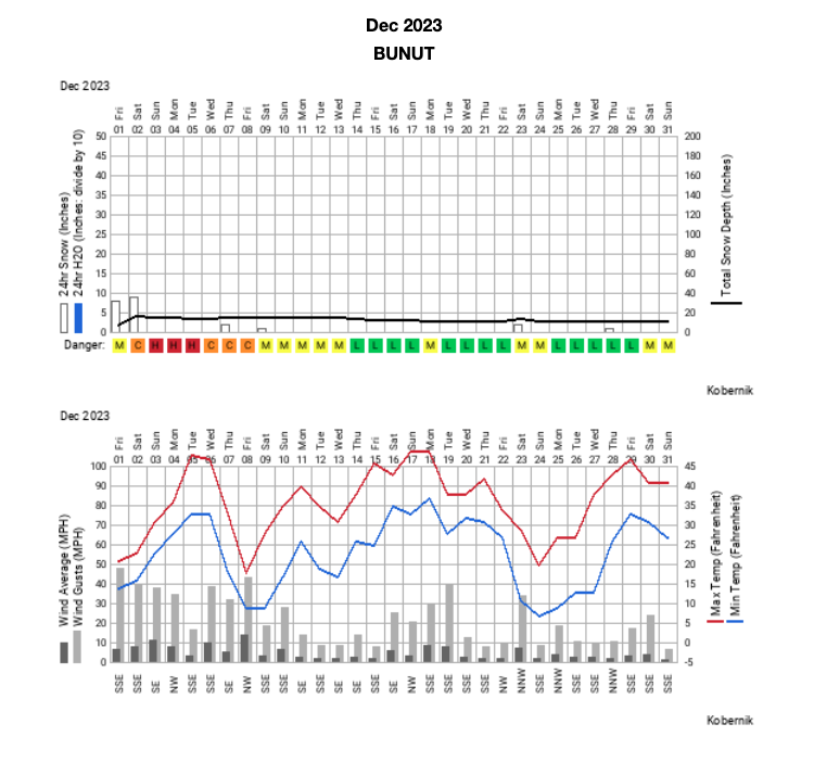
The graph below shows us the accumulated snowfall, total depth of snow, temperature, wind (as measured at Bunnells Ridge 8,800') and the daily Provo UAC Avalanche Forecast for the month of December.
Recent Avalanches
On Wednesday we had a report of a wind-drifted snow avalanche on Provo Peak which was triggered from the ridge. Read all the Observations HERE.
Ad
Avalanche Problem #1
Normal Caution
Type
Location
Likelihood
Size
Description
Under clear skies and with cold temperatures, the snow surface continues to weaken and, in some places, where the snow is less than 2' deep the facets are weak from the surface to the ground. Right now, your biggest concern in these low snowpack zones is sinking to the ground and hitting the summer surface (rocks, stumps). This weak snow is something we are paying attention at all elevations for a couple of reasons:
  • Ridgelines where even the lightest wind transport could lead to a slab forming over this weak snow and create avalanches in isolated areas,
  • Steep shady aspects where the weak surface snow is creating dry loose avalanches that in some cases are enough to push a rider around
  • For the future when we get new storm snow or wind-drifted snow on top of this weak layer
All of the avalanches I have seen over the last week are consistent with LOW danger. They have been small avalanches in isolated or extreme terrain. But any one of these slides above a cliff band or in a steep rocky gully would be enough to injure a rider. Continue to practice good backcountry travel techniques; make sure everyone in your group has a working transceiver, shovel, probe and only expose one person at a time while traveling in avalanche terrain.
General Announcements
This information does not apply to developed ski areas or highways where avalanche control is normally done. This forecast is from the U.S.D.A. Forest Service, which is solely responsible for its content. This forecast describes general avalanche conditions and local variations always occur.