Forecast for the Ogden Area Mountains

Drew Hardesty
Issued by Drew Hardesty for
Friday, April 15, 2022
Most terrain has a MODERATE avalanche danger; however a CONSIDERABLE danger exists in steep wind drifted terrain in the high elevations. Human triggered avalanches 1-2' deep are likely in the wind zone.
Follow safe travel protocol:
  • Make a plan.
  • One at a time.
  • Carry and know how to use your rescue equipment.

Cloud cover will be the WILD CARD. Any sun or greenhousing today will probably make WET AVALANCHES the primary concern.
Low
Moderate
Considerable
High
Extreme
Learn how to read the forecast here
Special Announcements
Our last regular forecast is Sunday, April 17th. Intermittent forecasts will be issued through April based upon weather conditions which affect avalanche danger.
Weather and Snow
Snowfall on a west to southwest flow has added up to 5-7" (0.60"SWE). We should see a few more inches this morning before precipitation turns more showery in the mid to late morning hours. Temperatures are in the mid-20s. Winds are from the west-southwest, blowing15-20mph with gusts to 35.
Whatever pans out for this current system will add to the mid week snowfall of 20-26" (1.64" SWE).

Skies will transition from obscured to overcast to eventually partly cloudy by mid/late afternoon. Winds will be west-southwesterly, blowing 25 with gusts to 40. Temperatures will be in the mid-20s up high, the mid-30s down low. Another storm arrives later tomorrow with more wind and less snow. The long term forecast looks classic spring - whiplashing temperatures and occasional periods of wind and snow.
Skiing and riding conditions were excellent yesterday morning, although greenhousing took its toll by the afternoon. Coverage has improved but take caution that the late March warm-up burned many southerly aspects to dirt. Traumatic injury is possible with the thinly veiled stumps and rocks.
Recent Avalanches
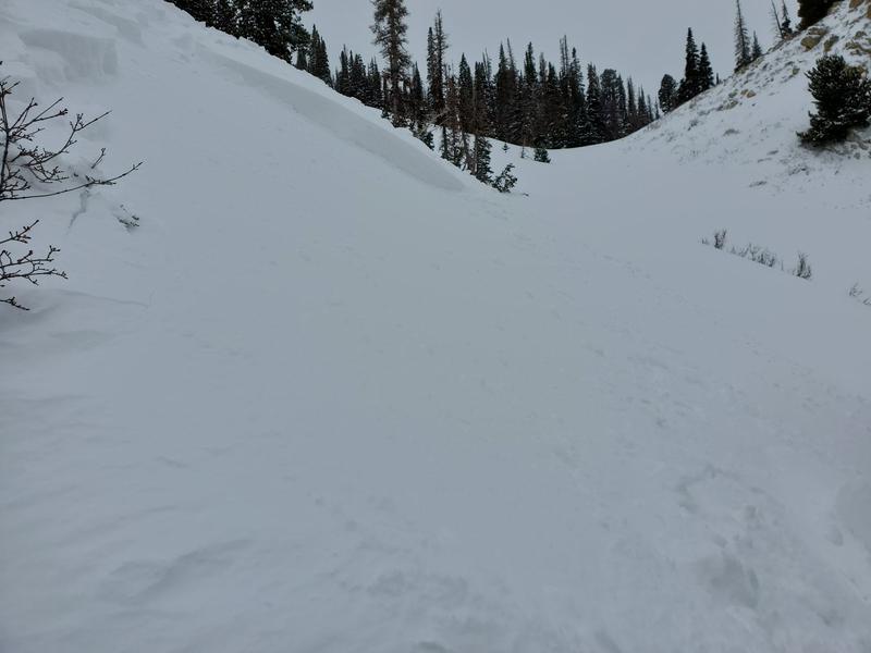
Ski area avalanche teams reported no results but Joe Keeler noted extensive drifting in the upper elevations near Ben Lomond (photo of intentionally triggered wind slab in the upper Cutler gulley.
Cornices built over the week have also been described as sensitive along the ridgelines.
Ad
Avalanche Problem #1
Wind Drifted Snow
Type
Location
Likelihood
Size
Description
Active wind transport at the mid and upper elevations will be the main concern for today. North to east to south facing aspects will hold most of the drifts, but terrain channeling will allow for wind drifts to be found around terrain features of all aspects. Human triggered wind drifts will be likely. Watch for shooting cracks as indicators of instability.
Avalanche Problem #2
New Snow
Type
Location
Likelihood
Size
Description
It will be possible to trigger sluffs and pockets of shallow soft slabs in the steepest terrain of all aspects this morning. Storm snow instabilities from the mid-week storm have probably settled out by now, but any new snow slide today may crowbar out any of these older weaknesses within the storm snow or down to the old dust layer 18-24" down.

THE WILD CARD (AGAIN): If the strong mid-April sun comes out for periods of time and/or is accompanied by intense greenhousing, WET AVALANCHES may become the primary concern. Direct sun will affect the solar aspects while greenhousing will rapidly affect the cold snow on all aspects, even the mid-elevation northerly aspects. YOU'LL NEED TO BE YOUR OWN FORECASTER to see how the sky cover affects the snow surfaces.
General Announcements
Who's up for some free avalanche training? Get a refresher, become better prepared for an upcoming avalanche class, or just boost your skills. Go to https://learn.kbyg.org/ and scroll down to Step 2 for a series of interactive online avalanche courses produced by the UAC.
This information does not apply to developed ski areas or highways where avalanche control is normally done. This forecast is from the U.S.D.A. Forest Service, which is solely responsible for its content. This forecast describes general avalanche conditions and local variations always occur.