


Forecast for the Ogden Area Mountains

Issued by Nikki Champion on
Thursday morning, March 3, 2022
Thursday morning, March 3, 2022
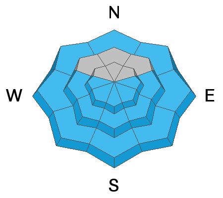
Such warm temperatures will cause the avalanche danger to quickly rise to MODERATE on mid and upper elevation slopes facing east through south and west, where natural and human-triggered wet-loose avalanches will become possible.
There is also a MODERATE avalanche danger for triggering soft slabs 1' to 2' deep, failing on a buried persistent weak layer on mid and upper elevation steep slopes facing northwest through north and east.
The remaining aspects at all lower elevations have a LOW danger.

Low
Moderate
Considerable
High
Extreme
Learn how to read the forecast here
 Weather and Snow
This morning, there are a few clouds in the sky and mountain temperatures are in the upper 30s °F and low 40s °F. Winds are blowing from the southwest at speeds of 15-25 mph, with the highest ridgelines hitting gusts near 40 mph.
Today, as the ridge overhead continues to break down ahead of two approaching storm systems, we will see a slight increase in southwest winds and building cloud cover. Mountain temperatures will climb into the mid 50's °F. The winds will be from the southwest and blow at speeds of 10-25 mph throughout the day. Upper elevation ridgeline gusts could reach 45 mph.
The much anticipated weekend storm is still slated to impact Utah over the weekend, and the big question is... how much snow will we get? By Monday, the video below shows roughly 12-15" of new snow (1.2" water). The famous plumes show a mean solution of 20-25" (1.2" water) of new snow. I suppose time will tell.
 Recent Avalanches
No new avalanches reported in the Ogden area backcountry. Ski resorts continue to report another round of small wet loose avalanches as the sun heated the southerly terrain. Outside of heat-related issues, within the Central Wasatch there was one skier-triggered avalanche on the Firewater Run, of Little Water Peak. This was a soft slab avalanche on a NE aspect at 9600' that broke 10" and 80' wide. This avalanche failed on the January/February layer of facets.
Be sure to check out all the observations HERE.

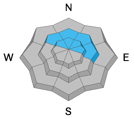
Avalanche Problem #1
Wet Snow
Type
Location
Likelihood
Size
Description
Overnight, most weather station temperatures did not dip below freezing. This means the snowpack likely did not fully re-freeze overnight. With a lack of solid re-freeze, the wet activity can start earlier this morning, especially once the sun warms the southerly facing terrain, loosening the bonds between the grains as the snow surface becomes damp. With enough direct sun and warming temperatures, the snow can lose all its strength and begin to slide down steep terrain naturally.
If you're in sunny terrain and the snow surface is wet and unsupportable to your weight, it's time to change aspects or head home. Rollerballs/pinwheels are generally the first sign of unstable wet snow. Natural and human-triggered loose wet avalanches are possible today.
Avalanche Problem #2
Persistent Weak Layer
Type
Location
Likelihood
Size
Description
The January/February drought resulted in widespread weak, faceted snow across the northern end of the compass at mid and upper elevations. In Ogden, these weak faceted grains are now covered by roughly 6-12" of new snow, shallow wind drifts, and some variable crusts from the past week.
Over the past few days, we have been seeing avalanches failing on this persistent weak layer as soft slab avalanches roughly 8-16" deep and up 80' wide. Generally, these avalanches have been confined to isolated terrain features where the slab is slightly stiffer and more connected. We saw a prime example of this yesterday on Little Water Peak.
The challenging part right now is figuring out where a slab sits atop the weak faceted grains. In areas that have not received enough wind, or enough snow there still may not be a slab formed. It also seems the most suspect terrain is the mid to upper elevation sheltered slopes that did not see any high winds or sun during our January/February dry spell, making the surface facets that much weaker.
I am uncertain how the overnight temperatures and warming have or will affect the snow on the mid and upper elevation shady slopes. As we continue to add a bit more wind and go on multiple days of above freezing temperatures, this slab seems to only be becoming more cohesive increasingly the likelihood of triggering an avalanche. The warming temperatures are changing the game, and I would now approach steep northerly facing terrain with caution.
Cracking and Collapsing is a bullseye clue to unstable snow and should not be ignored.
General Announcements
Who's up for some free avalanche training? Get a refresher, become better prepared for an upcoming avalanche class, or just boost your skills. Go to https://learn.kbyg.org/ and scroll down to Step 2 for a series of interactive online avalanche courses produced by the UAC.
This information does not apply to developed ski areas or highways where avalanche control is normally done. This forecast is from the U.S.D.A. Forest Service, which is solely responsible for its content. This forecast describes general avalanche conditions and local variations always occur.