Join us at our 2nd Annual Blizzard Ball

Forecast for the Ogden Area Mountains

Drew Hardesty
Issued by Drew Hardesty on
Tuesday morning, March 14, 2023
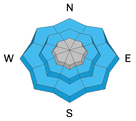
A MODERATE avalanche danger exists for developing soft and hard slabs of wind drifted snow. These drifts will be most prevalent on west to north to east facing slopes. Wet loose avalanches will also become a problem with rain to 8000' this afternoon/evening. Cornices and roof avalanches will be increasingly dangerous.

I expect the avalanche danger to reach HIGH tonight into tomorrow with the storm.
Low
Moderate
Considerable
High
Extreme
Learn how to read the forecast here
Special Announcements
The UAC is currently working with the operation involved in Thursday's fatal avalanche in the Uintas to prepare a report. Please be patient as we sort out the details of this complicated incident. A preliminary report is available HERE.

Please consider donating to the spring campaign to help our team implement innovative tools and better provide you with the information you rely on.
Weather and Snow
Skies are partly cloudy but there are hints of things to come.
It's warm. Mountain temperatures are in the upper 20s to low 30s.
It's windy. Winds have picked up out of the southwest the last few hours and are blowing 30mph with gusts to 45mph. You just wait.
A powerful and well advertised atmospheric river event kicks in late afternoon with light to moderate rain to 8000'. Winds will only continue to ramp up and become strong this afternoon into the overnight hours. I wouldn't be surprised to see some gusts reach toward 100mph along the high/exposed peaks. Heavy rain and heavy snowfall kicks in into the overnight hours and into tomorrow with storm totals of 16-24"+ (2" SWE) of initially heavy, wet, dense snow. Cooler air arrives tomorrow morning, lowering the rain/snow line and decreasing snow densities in the mountains. This event will favor (punish?) the Provo area mountains - 3.0" of snow-water-equivalent would not be out of the question.

I expect some clearing Thursday into Friday with unsettled weather into the weekend. The weather pattern remains active into next week.
Recent Avalanches
No reports of avalanche activity in the backcountry.
We strive to understand patterns or hints of patterns with the snowpack and with avalanches to make a coherent assessment...and sometimes things aren't as clean cut as we would like. Forecaster Dave Kelly put some thoughts down on paper. His essay Early Morning Pattern Hunting-What's the Problem? is worth the read.

Get all observations HERE.
Ad
Avalanche Problem #1
Wind Drifted Snow
Type
Location
Likelihood
Size
Description
***New and developing soft and hard slabs should be on your radar, particularly in the afternoon. Look for blowing and drifting snow and avoid any fresh deposits of wind blown snow. These drifts may be more prominent on west to north to east facing slopes, but terrain channeling allows for slabs to develop on a variety of aspects well off the ridgelines and in the mid-elevations.
***Lingering "new snow" instabilities: We have had a lot of snow over the last few weeks and there are areas where we are finding decomposing stellar crystals, buried ice crusts, rime crusts, and isolated areas of faceted snow buried 1-3' from the surface and it's a good reminder that strange weather (like above average snowfall) leads to strange avalanches. There is a possibility of triggering an isolated avalanche on a new/old snow interface that is buried 1-3' from the surface. The solar aspects, particularly southeasterly facing slopes are acting more like a northerly aspect.

CORNICES are currently large and growing and may be particularly sensitive and tender during periods of sun, warm temperatures and strong winds. Give cornices a wide berth as they often break farther back than expected. Cornices are signs that a slope has been wind loaded and a cornice fall could trigger a larger slab of wind-drifted snow below.
Avalanche Problem #2
Wet Snow
Type
Location
Likelihood
Size
Description
Natural and human triggered wet loose avalanches will be increasingly likely with rain-on-snow up to 8000' this afternoon/evening. Choose different or low angle terrain if you find yourself bogging down in unsupportable glop.
Keep the ice tools stowed: Surprisingly, there is still some ice climbing to be had across northern Utah but these crags will be very dangerous. Rain will trigger wet loose avalanches to run down the gullies and down the ice flows.
Additional Information
Forecaster's Corner: It's not green light. None of the forecasters have felt altogether comfortable with the avalanche conditions and we're still playing heads-up, avoiding some steep terrain with bad consequences.
General Announcements
This information does not apply to developed ski areas or highways where avalanche control is normally done. This forecast is from the U.S.D.A. Forest Service, which is solely responsible for its content. This forecast describes general avalanche conditions and local variations always occur.