Forecast for the Ogden Area Mountains

Trent Meisenheimer
Issued by Trent Meisenheimer on
Sunday morning, February 9, 2025
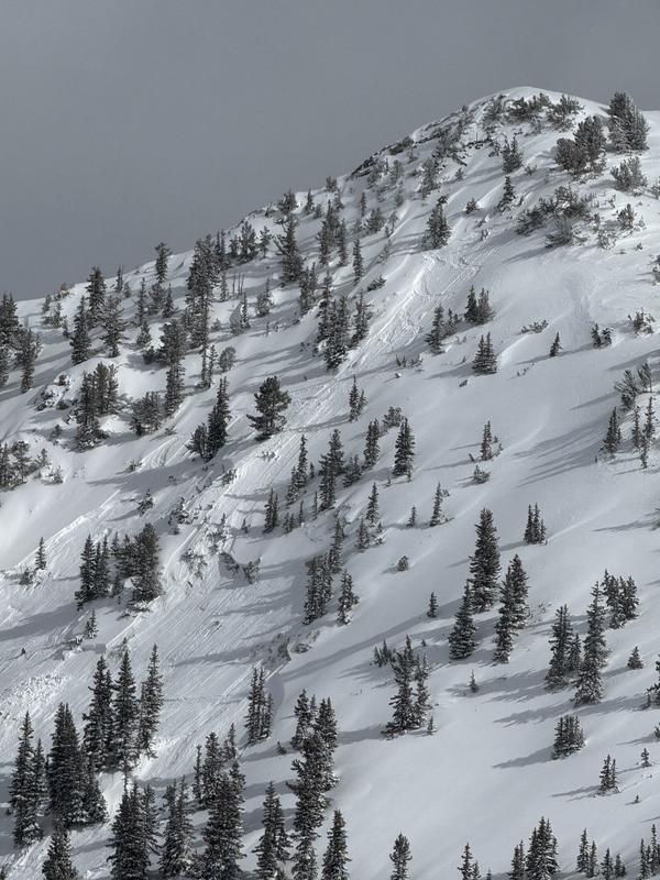
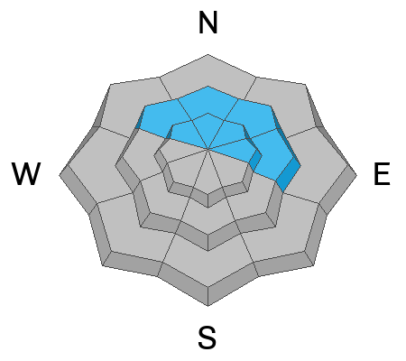
The avalanche danger is MODERATE on all mid and upper-elevation steep slopes for slab avalanches. Here, avalanches can fail within the new snow or at the old/new snow interface. On northerly facing terrain, these avalanches could step down into buried weak layers of faceted snow, making them more dangerous. Human-triggered avalanches 1 to 3 feet deep are possible today.
Low
Moderate
Considerable
High
Extreme
Learn how to read the forecast here
Special Announcements
We are deeply saddened to report an avalanche fatality in East Bowl of Silverfork that happened yesterday (pic below). Details are still limited, but UAC staff will visit the site today. We will provide a full accident report in the coming days.
Weather and Snow
Yesterday afternoon, another cold front pushed through, leaving behind an additional 1 to 3 inches of new snow (0.05-0.10" water). This brings the 36-hour snow total to 6 to 12 inches (1.15-1.37" water).
Under clear skies, the mountain temperatures range from 5-15 °F. The wind is from the northwest and blows at speeds of 5-15 mph with gusts into the 20s. Today, we will remain under a cool/dry northwest flow with plenty of sunshine and temperatures rising into the mid 20°F. Riding and turning conditions are the best they've been all year.
Recent Avalanches
None.
Ad
Avalanche Problem #1
New Snow
Type
Location
Likelihood
Size
Description
With 6 to 12 inches of new snow, it's hard to know precisely how touchy the new snow will be this morning. Today, we could see avalanches fail within the new snow or at the new/old snow interface. We could also see avalanches step down into our January buried facets, making these deeper and more dangerous (see pwl). Use test slopes, slope cuts, and shovel tilt tests to see how this new snow is behaving.
Avalanche Problem #2
Persistent Weak Layer
Type
Location
Likelihood
Size
Description
There are two buried persistent weak layers (PWL) in the snowpack:
1. The upper layer buried down 12-24 inches formed during cold, clear weather in late January and has been buried by recent storms and wind-drifted snow. Today, this layer could become active with the additional water weight we have added in the past 24 hours. Avalanches 1 to 3 feet deep are possible.
2. The lower layer, near the ground, formed in December and has caused large avalanches, including one fatality on Beer Hill, Monte Cristo. This layer is most problematic in steep rocky terrain or on repeater slopes that previously avalanched this winter. Avalanches up to 2 to 4 feet deep are possible.
Avalanche Problem #3
Wet Snow
Type
Location
Likelihood
Size
Description
I am unsure if there will be wet avalanche activity today. Cool temperatures and light winds might be enough to keep the wet activity at bay. However, if the snow becomes damp or you see roller balls, it's time to get off and out from under steep, sunny slopes.
General Announcements
This information does not apply to developed ski areas or highways where avalanche control is normally done. This forecast is from the U.S.D.A. Forest Service, which is solely responsible for its content. This forecast describes general avalanche conditions and local variations always occur.