Donate to the 2024 Spring Campaign to help rebuild the UAC website.

Forecast for the Ogden Area Mountains

Greg Gagne
Issued by Greg Gagne for
Wednesday, February 6, 2019
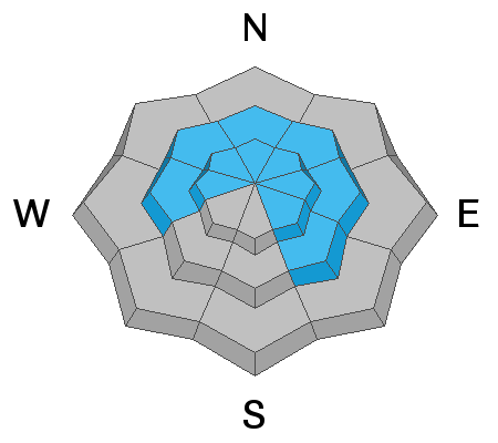
The avalanche danger is HIGH at upper elevations, and CONSIDERABLE at mid elevations, facing west, through north, through southeast which are wind-drifted. Upper elevations facing south and southwest have a CONSIDERABLE hazard. Avalanches are still possible on southerly aspects at mid elevations, as well as at low elevations where the danger is MODERATE.
Low
Moderate
Considerable
High
Extreme
Learn how to read the forecast here
Special Announcements
Check out the latest podcast - The Risks and Rewards of Ski Patrol - A Conversation with Jake Hutchinson.
Weather and Snow
Overnight snowfall totals in the Ogden mountains range from 2-5" and temperatures are in the mid teens. The sustained period of strong south/southwest winds finally relaxed yesterday, and have shifted to the north, gusting into the 20's and 30's mph at the upper elevations. Since Sunday, the Ogden mountains have recorded 2-3' of snow with nearly 3" of water.
For today, winds will be from the northwest, gusting into the 20's and 30's at the upper elevations. Up to 6" of snowfall is expected. Temperatures will remain in the teens.
Recent Avalanches
No avalanches were reported from the Ogden backcountry on Tuesday. Despite the widespread presence of wind drifts at the upper elevations, only minimal results from control work at Ogden resorts were reported.
Ad
Avalanche Problem #1
Wind Drifted Snow
Type
Location
Likelihood
Size
Description
The Ogden mountains had a sustained 72-hour period of strong winds from the south/southwest, creating large and widespread drifts at the mid and upper elevations. Although control work indicated these drifts to be mostly unresponsive, I generally don't trust such wind events, and would avoid steep, wind-loaded terrain.
Avalanche Problem #2
New Snow
Type
Location
Likelihood
Size
Description
The Ogden mountains can expect up to 6" of new snow during the day today, but any period of high precipitation may produce sensitive sluffs and shallow storm slabs.
General Announcements
This information does not apply to developed ski areas or highways where avalanche control is normally done. This forecast is from the U.S.D.A. Forest Service, which is solely responsible for its content. This forecast describes general avalanche conditions and local variations always occur.