Forecast for the Ogden Area Mountains

Greg Gagne
Issued by Greg Gagne for
Friday, February 23, 2024
The avalanche danger is CONSIDERABLE on mid and upper elevation slopes facing east and southeast for avalanches failing in a persistent weak layer buried 2-3' deep. There is a MODERATE danger on slopes facing west through south and southeast for wet snow avalanches.
The avalanche danger is MODERATE on wind-loaded slopes facing northwest through northeast at the mid and upper elevations. Low elevation northerly slopes have a LOW danger.
Low
Moderate
Considerable
High
Extreme
Learn how to read the forecast here
Weather and Snow
6 am: Skies are clear under a nearly-full moon (the February full moon is named - appropriately - the Snow Moon) and temperatures are in the low to mid 20's F. Winds are from the west and light, gusting to near 20 mph along the Ogden Skyline.
Today: Sunshine with temperatures warming into the upper 20's F at upper elevations and 35°-45° F at low and mid elevations. Winds will be from the west and remain light, with gusts around 20 mph on along exposed, upper elevation ridgeslines.
Extended: A sunny weekend with mild temperatures. Winds increase on Monday ahead of what currently appears as a remarkably-strong cold front with heavy snow and strong winds by Tuesday.


Travel and riding conditions are superb, although some slopes may be crusted due to sunshine and greenhousing on Thursday.
❄️ Storm totals since Monday, February 19:
  • Ogden Mountains: 18-28" snow with 2.35 - 2.75" SWE
  • Upper Cottonwoods: 12-27" snow with 2.0 - 3.30" SWE (Snow/Water Equivalent)
  • Park City Ridgeline: 10-17" snow with 1.5 - 2.0" SWE
  • Provo Mountains: 8-12" snow with 2.75" SWE
Recent Avalanches
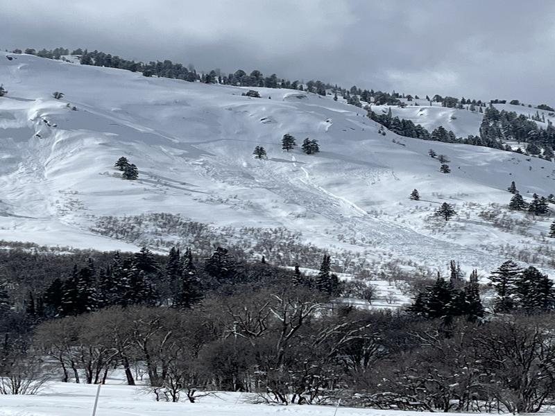
Natural avalanches were reported from the Chilly Peak Slabs (T Budge photo below), likely failing sometime on Wednesday. Moab forecaster Eric Trenbeath headed north and joined Mark Staples on Bountiful Peak where they found large cornices that may become an issue with warming temperatures the next few days.
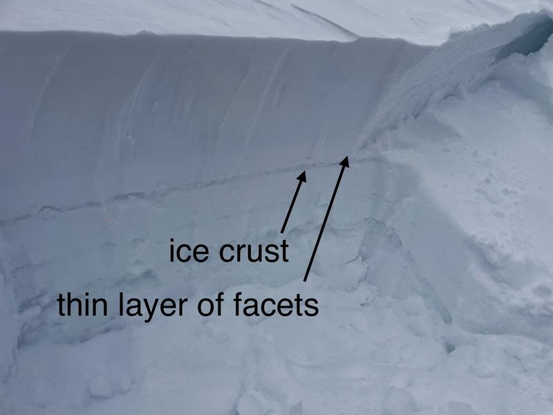
To our south, we received a report late Thursday evening of a very large avalanche in Mary Ellen Gulch in American Fork Canyon. Details are scant and unconfirmed, but it is estimated at 1,500' wide and 2' deep, possibly breaking on the layer of faceted snow above a crust. UAC forecasters will visit the scene on Friday.
Ad
Avalanche Problem #1
Persistent Weak Layer
Type
Location
Likelihood
Size
Description
On some "solar" slopes - particularly those facing east and southeast - there exists a persistent weak layer (PWL) of facets just above a crust which was buried by storms beginning February 14. Mark Staples's photo below shows this structure which can be found about 3' below the snow surface. The reactivity of this layer varies from one slope to the next, but it is possible Thursday's large avalanche in Mary Ellen Gulch may have failed on this layer. With many large cornices on many ridgelines, any natural or human-triggered cornice fall may trigger an avalanche failing on this PWL.
I'm handling this problem by avoiding it and heading to northerly facing slopes where the snow quality is superior and this avalanche problem doesn't exist.
Avalanche Problem #2
Wet Snow
Type
Location
Likelihood
Size
Description
Strong sunshine and warm temperatures will create wet-loose avalanches on steep sunny slopes. On mid and upper elevation slopes facing southeast, any wet avalanches may trigger larger slab avalanches failing on the PWL. Wet snow is the easiest avalanche problem to avoid by simply moving to shady slopes once the snow surface becomes wet.
Avalanche Problem #3
Wind Drifted Snow
Type
Location
Likelihood
Size
Description
Strong winds this past week created dense slabs of wind-drifted snow at the upper elevations and some mid-elevation slopes facing northwest through southeast. Some of these wind drifts may be reactive if they formed on top of graupel. The graupel layers vary, but they can often be found below steeper cliff bands where graupel can pool (accumulate). Natural or human-triggered cornice falls could cause a larger avalanche failing on a wind-loaded slope. Any recent wind drifts were covered by snowfall Wednesday night, so you will need to dig down 1-2' to search for them.
General Announcements
This information does not apply to developed ski areas or highways where avalanche control is normally done. This forecast is from the U.S.D.A. Forest Service, which is solely responsible for its content. This forecast describes general avalanche conditions and local variations always occur.