Fall Auction is now live! Check it out now

Forecast for the Ogden Area Mountains

Nikki Champion
Issued by Nikki Champion on
Thursday morning, December 29, 2022
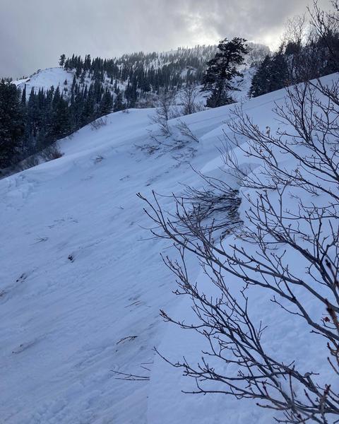
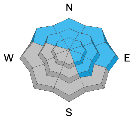
The avalanche danger is CONSIDERABLE on all upper and mid-elevation aspects where high snowfall totals and elevated winds have created dangerous avalanche conditions. Give extra caution to northerly facing terrain where a persistent weak layer of faceted snow is now buried 2-5' deep. Any avalanche triggered within the new snow or the wind-drifted snow has the potential to step down into deeper weak layers in the snowpack, creating a very large and dangerous avalanche.
The avalanche danger is also CONSIDERABLE on low-elevation slopes facing northwest north and east where the faceted grains became fully saturated.
The avalanche danger is MODERATE on remaining low-elevation slopes.

Natural avalanches are possible, and human-triggered avalanches are likely today. With another storm on the way, avalanche danger will be on the rise again moving into the weekend.
Low
Moderate
Considerable
High
Extreme
Learn how to read the forecast here
Special Announcements
Check out this great blog post that Dave put together discussing the persistent weak layer, and the forecaster's current mindset while dealing with it. You can read the full post HERE.
Weather and Snow
This morning, the skies are overcast and it continues to lightly snow in the mountains. Temperatures are in the mid-teens. Westerly winds are currently blowing in the mid-20s with gusts up to 40 mph at the highest ridgelines. Snowfall continued throughout the day yesterday bringing snowfall totals up to 5-21" (2.0-2.7" of water).

Today, an additional dusting to 2" of snow could fall before skies become partly cloudy and we experience a brief drying period. Temperatures will be in the low-20s F. Winds will be a bit gusty before sunrise, and late this afternoon. Mid-elevation winds will blow from the west-northwest averaging 5-15 mph with gusts up to 25 mph and upper elevation gusts up to 45 mph.

This was just the first in a series of three storms that are moving through Utah over the next week. After a break in the storms today, the next system should begin moving through the area on Friday slated to bring strong winds and heavy snowfall.
Recent Avalanches
Overall, there were very few reports of avalanches in the backcountry yesterday. Both backcountry users and ski resorts did report sensitive soft slabs of wind-drifted snow and fast-running dry loose avalanches. Yesterday, there was one close call, where the avalanche did seem to step down more deeply into the PWL and entrain more snow. This avalanche broke 2' deep, and 100' on an East facing aspect at 6,900'. Greg will be investigated this accident today. You can find an excellent write-up, and key takeaways from the party HERE.
Image from Rodeo Ridge close call. (B. Brandt)
Ad
Avalanche Problem #1
Persistent Weak Layer
Type
Location
Likelihood
Size
Description
Most avalanche activity on this persistent weak layer has been on northerly-facing terrain. This layer DOES exist at other aspects and elevations and it could begin producing avalanches as it gets loaded by heavy snowfall and strong winds.

The areas with the most uncertainty, and therefore the highest level of concern for me are areas that have a generally substantial snowpack but had still been showing signs of propagation before this storm. These slopes will hold more water weight before they avalanche much wider and deeper. These will be unsurvivable avalanches. The uncertainty lies in the overall snowfall, water totals, and how quickly we overload the snowpack. While it doesn't seem like this first system was enough to overload the faceted grains, and for new snow and wind-drifted snow avalanches to begin stepping down deeper into this layer - in the coming days we will continue to add more snow and more wind. As we continue to add these two large stressors to the snowpack, we do know that the likelihood of tipping the scales and beginning to see large avalanches on the persistent grains again only continues to increase.
Personally, I'm going to continue staying off of and out from under slopes over 30 degrees as the current snowpack adapts to the new snow and wind.
Avalanche Problem #2
Wind Drifted Snow
Type
Location
Likelihood
Size
Description
With moderate winds and so much soft snow available for transport, you are likely to find sensitive slabs of wind-drifted snow on all upper-elevation slopes, and mid-elevation terrain features that allow for drifting snow to accumulate. The new soft slabs will be most pronounced on lee-ward facing slopes, but high winds can load any aspect because winds swirl and change direction as they pass through the mountains, this is known as cross-loading.
What to do? Look for evidence of fresh drifts and wind slabs that look wavy, rounded, smooth, and pillow, and avoid steep terrain where you could trigger them.
Avalanche Problem #3
New Snow
Type
Location
Likelihood
Size
Description
With up to 21" of new snow over the past 24 hours will create both sensitive soft slabs of new snow and fast, long-running sluffs on all aspects at mid and upper elevations.
Heads up: The lower elevations in the Ogden area have received a lot of rain on the front end of this storm, close to 4" of SWE at Ben Lomond Trail. While temperatures have dropped significantly and the saturated snowpack will hopefully freeze and not cause any issues, there is still some uncertainty with this much water. I would pay attention to low-elevation slopes that possess weak faceted early-season grains and show signs of remaining wet. If traveling through this lower elevation rain-soaked terrain I would avoid any location that has not experienced an actual freeze, and one could sink through the entire snowpack to the ground. This could be a red flag that wet avalanches could still occur at these elevations.
Additional Information
Check out this weather discussion that Mark and I had talking about the forecast, and areas of certainty versus uncertainty within the snowpack.
General Announcements
Help support the UAC while doing your Holiday Shopping. The UAC's Holiday Silent Auction opens at 8:00 AM MT on December 26 and will close at 8:00 PM MT on January 2. Take a look at items and bid HERE.

This information does not apply to developed ski areas or highways where avalanche control is normally done. This forecast is from the U.S.D.A. Forest Service, which is solely responsible for its content. This forecast describes general avalanche conditions and local variations always occur.