AVALANCHE WARNING!! Tap for info

Forecast for the Ogden Area Mountains

Dave Kelly
Issued by Dave Kelly on
Saturday morning, December 28, 2024
Today, the avalanche danger is HIGH in upper-elevation terrain, and on mid-elevation northerly facing terrain. Avalanches may break 1'-3' deep and over 400' wide. Natural and human-triggered avalanches are likely.
There is a CONSIDERABLE avalanche danger on mid elevation west and southerly-facing slopes, and there is a moderate danger on low elevation slopes.

Avoid traveling in avalanche terrain on any slope steeper than, connected to, or below a slope that is greater than 30° in steepness.
Low
Moderate
Considerable
High
Extreme
Learn how to read the forecast here
Avalanche Warning
What: The avalanche danger for the warning area is HIGH today
When In effect from 6am MST this morning to 6am MST Sunday
Where: For the mountains of Northern and Central Utah, and Southeastern Idaho, including the Wasatch Plateau (Skyline)...Wasatch Range...Bear River Range...Wellsville Mountains
Impacts: Heavy snow combined with strong wind is creating widespread areas of unstable snow. Both human-triggered and natural avalanches are likely
What to do: Avoid all avalanche terrain. Stay off of and out from under slopes steeper than 30 degrees. Carry and know how to use avalanche rescue equipment. Find safer riding conditions on slopes less than 30° with no overhead hazard
Warning Times: Saturday, December 28, 2024 - 6:00am to Sunday, December 29, 2024 - 6:00am
Weather and Snow
Currently it is snowing lightly. Temperatures are in the mid 20's to low 30's °F. Winds are blowing from the west in the 20's gusting to the high 50's MPH. Overnight there was another 3"-8" of new snow and .30"-1.00" water reported which brings our storm totals to 12"-22" of snow and 1.5"-2.65" of water.
For today, continued snowfall with 8"-16" of snow and 1"-1.5" of water forecasted. The snow densities could be quite high and increasing through the day as temperatures warm up. Temperatures will be 32-38 °F and the freezing level may rise to 8,000'. There is a chance we could see rain at lower elevations later this afternoon. Winds will blow primarily from a westerly direction 20 gusting to 25 MPH at the lower ridgelines and 45 gusting to 55 MPH at the higher and more exposed ridgelines.
Recent Avalanches
Yesterday, we had one observation from Cutler Ridge. Bill Brandt found localized cracking and poor snowpack structure. Ski area operations reported soft slab wind drifts that were reactive to skis. Read all the observations HERE.
Ad
Avalanche Problem #1
Persistent Weak Layer
Type
Location
Likelihood
Size
Description
There is a weak layer of faceted snow now buried under the new storm snow. This weak snow has now been and will continue to be overloaded creating dangerous avalanche conditions. Avoid being on, underneath, or adjacent to slopes steeper than 30° in steepness. Avalanches involving PWLs can be triggered remotely (from a distance).
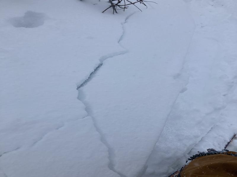
Photo below showing cracking on Cutler Ridge, if you see signs of cracking or collapsing then avoid slopes steeper than or connected to slopes greater than 30° in steepness.
Photo (Brandt)
Avalanche Problem #2
Wind Drifted Snow
Type
Location
Likelihood
Size
Description
Continued strong winds blowing from the west have now overloaded a weak snowpack. These wind drifted snow avalanches could be enough to catch and carry a rider, however combined with the buried persistent weak layers this could make for much larger avalanches breaking 1'-3' deep and up to 400' wide. The very nature of strong winds is that they will load slopes on all aspects regardless of wind direction.
Avalanche Problem #3
New Snow
Type
Location
Likelihood
Size
Description
Watch for sensitive soft slabs of new snow, especially during periods of increased precipitation. Today's snowfall may have density inversions which can create sensitive soft slabs of new snow. These by themselves may not be an issue to riders, but combined with the buried persistent weak layer (PWL) and some wind could create bigger avalanches. There is also a chance of rain on snow at elevations below 8,000' later this afternoon. You could see wet loose roller balls in lower elevation terrain.
Additional Information
It's not all doom and gloom. This will settle out eventually and, in the meantime, you can travel on slopes less than 30° in steepness, check out some of our free online learning, or work on your rescue skills in lower angle meadows.
General Announcements
This information does not apply to developed ski areas or highways where avalanche control is normally done. This forecast is from the U.S.D.A. Forest Service, which is solely responsible for its content. This forecast describes general avalanche conditions and local variations always occur.