


Forecast for the Ogden Area Mountains

Issued by Evelyn Lees on
Wednesday morning, December 19, 2018
Wednesday morning, December 19, 2018
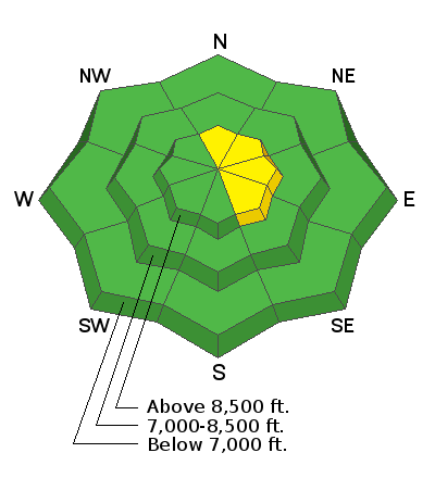
There is a MODERATE danger for triggering a new or old wind slab or wind drift, which will be scattered throughout the mid and upper elevation terrain.
Out of the wind affected terrain, the avalanche danger is mostly LOW in the Ogden area mountains. Watch for unstable snow on isolated terrain features. As always, avoid being on or beneath large cornices along the ridge line.
Low
Moderate
Considerable
High
Extreme
Learn how to read the forecast here
 Special Announcements
The new UAC IOS mobile app is now available on the app store. Check out the new "My Weather" feature.
Snowbasin is currently closed to uphill travel. Please review their update uphill travel policy.
Check out the new free online avalanche course series developed by the Utah Avalanche Center. This is a great way to refresh your skills or prepare you for a Backcountry 101 or Level 1 class.
 Weather and Snow
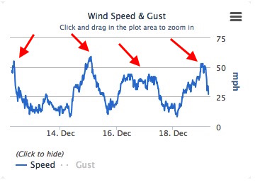
An arriving “storm” may produce a few inches of snow today, but the bigger impact will be the westerly winds. They ramped up overnight, with ridgelines averaging 40 to 50 mph, gusting in the 60s, and mid elevations averaging 10 to 5 mph, with gusts in the 30s. Speeds will continue to gradually decrease throughout the day. Temperatures are in the 20s at the mid and upper elevations, with 30s at the trail heads, and won’t warm to much today.
Wondering where all the powder went? Sunny slopes are crusted, and multiple wind events in the past 7 days have created widespread wind damage. Search for patches of settled powder on shady, sheltered slopes.
Mt Ogden weather station, 9570’, shows the recent wind events. Notice - wind speeds have already dropped off the past few hours, as forecast.
 Recent Avalanches
No recent reports of avalanche activity.

Avalanche Problem #1
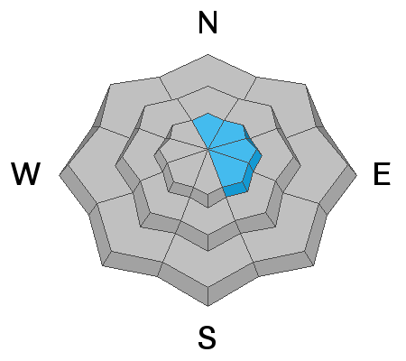
Wind Drifted Snow
Type
Location
Likelihood
Size
Description
Wind directions have ranged from the southwest to northwest, and speeds are strong enough to erode and drift some snow. Clues are an etched, hard snow surface where the winds have eroded snow and hard, rounded, hollow sounding drifts where snow has been deposited. With fast wind speeds, look for the new wind slabs, or drifts, at both upper and mid elevations. They will be on the lee sides of ridge crests and around terrain features, like gully walls, sub ridges and down into open bowls. Cornices may have grown, and be more sensitive again - avoid travel on and beneath the overhanging snow.
General Announcements
This information does not apply to developed ski areas or highways where avalanche control is normally done. This forecast is from the U.S.D.A. Forest Service, which is solely responsible for its content. This forecast describes general avalanche conditions and local variations always occur.