Forecast for the Ogden Area Mountains

Drew Hardesty
Issued by Drew Hardesty for
Monday, January 29, 2024
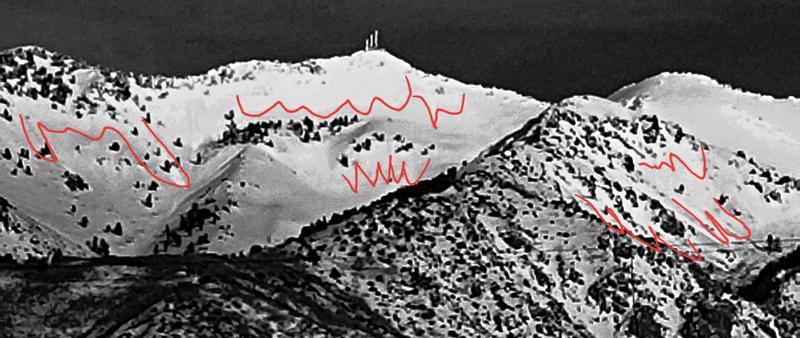
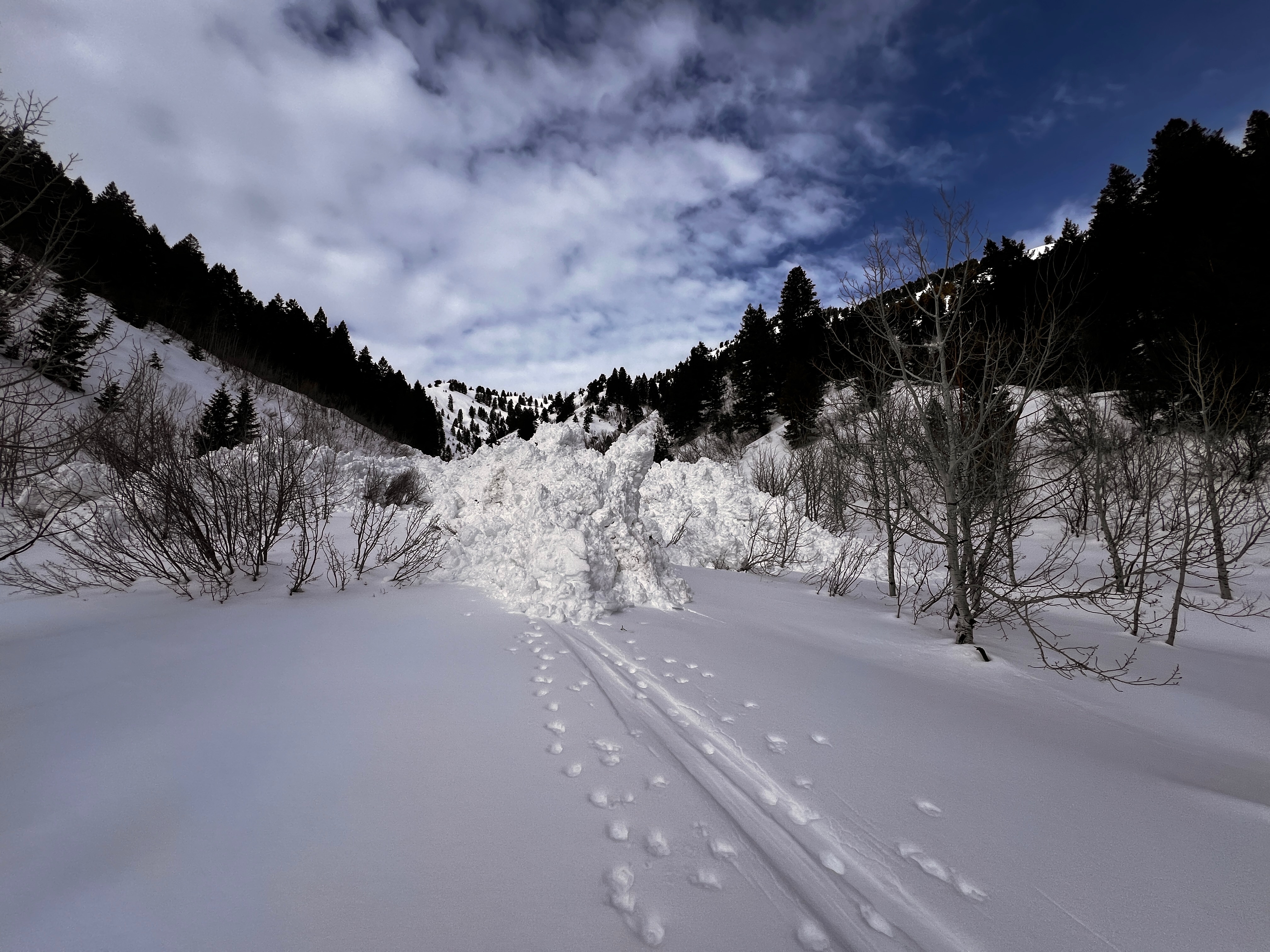
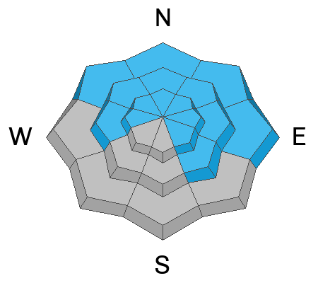
  • A MODERATE DANGER exists on steep west to north to southeast facing slopes for triggering a 2-5' thick hard slab avalanche that fails on a persistent weak layer. Human triggered avalanches are possible and more likely in steep, thin, rocky terrain.
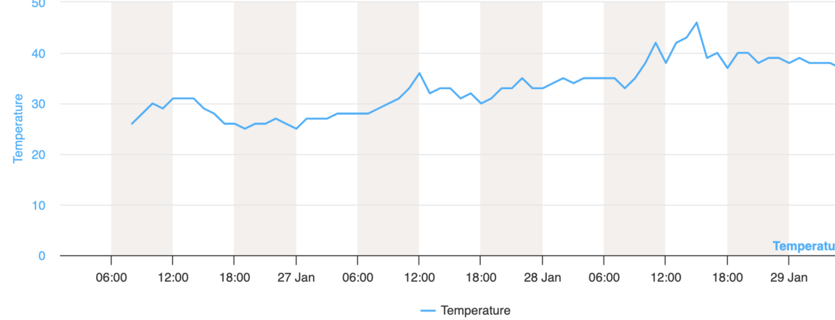
  • With clear skies and skyrocketing temps, the danger for wet avalanches will rise to CONSIDERABLE on all steep sunny (as well as low elevation shady) slopes. Don't overstay your welcome in the oven.
  • Last, don't be surprised to trigger new but shallow soft slabs of wind drifted snow in the highest elevations today.
Low
Moderate
Considerable
High
Extreme
Learn how to read the forecast here
Special Announcements
Join us for a Motorized Backcountry 101: Introduction to Avalanches class on February 2-3 down on the Skyline. Click HERE for more information.
Weather and Snow
Skies are clear.
Mountain temperatures are in the mid to upper 30s.
Winds are light from the northwest except along the highest elevations where hourly averages are 25-30mph.
The ridge of high pressure moves squarely overhead today and we'll have clear skies and diminishing winds. Mountain temperatures will skyrocket again to near 40°F along the ridgelines and perhaps 50°F at the base areas and trailheads. Temperatures will be even warmer Tuesday as the ridge moves to the east and we back to a southwest flow (winds now from the southwest) ahead of a storm later in this week (Thursday eve).
Riding conditions remain excellent in the sun and wind sheltered terrain. Solar aspects and low elevation northerlies have a crust that will soften with daytime warming. Developing surface hoar may be noted in sheltered terrain.

The January thaw: Note the increasing highs and lows the last couple of days: This is the Ben Lomond site in the north fork at 7700'. It's in what I call the "thermal belt": not as cold as the highest elevations and not subject to cold air pooling down low in the basins and drainages.
Recent Avalanches
With skyrocketing temps yesterday, many wet loose and a few wet slab avalanches barreled down steep solar terrain as they became wet and unstable. Derek Debruin captured some good images on the west flanks of Mt Ogden. In the Salt Lake mountains, a skier was caught and carried in a large avalanche that failed on our PWL from December. This was on a steep northwest facing slope on Gobblers Knob.
Ad
Avalanche Problem #1
Wet Snow
Type
Location
Likelihood
Size
Description
With clear skies and warmer overnight temperatures, wet avalanches will start to run earlier today than yesterday, starting on east then south then west and eventually some northwest facing slopes. In steep, sustained and confined terrain, some of these wet avalanches will run fast and far and easily lead to significant debris piles. We had lots of reports of long running destructive avalanches across the range (as noted by DeBruin) but also significant wet avalanches in Logan (Green Canyon) on a south facing aspect up high. (Benson photo) In some areas, much more destructive wet slab avalanches may occur, from either being pried out by wet loose sluffs from above, or - in some cases - melt water percolating down to structural interfaces (density changes and/or facets and crusts).
Travel advice: If you see pinwheels and rollerballs and are finding the snow start to become unsupportable, move on to low angle terrain or cooler aspects.
Avalanche Problem #2
Persistent Weak Layer
Type
Location
Likelihood
Size
Description
Triggering an avalanche into our buried PWL from December and buried January 4th is becoming increasingly difficult. We have heard of no cracking or collapsing recently and the last reported avalanche into this layering was well over a week ago in Black Canyon. That said, the prudent travel in this low probability high consequence regime to stack your cards and remain on low angle terrain.
General Announcements
This information does not apply to developed ski areas or highways where avalanche control is normally done. This forecast is from the U.S.D.A. Forest Service, which is solely responsible for its content. This forecast describes general avalanche conditions and local variations always occur.