31st Annual Backcountry Benefit - September 12th - Tickets Available Here!

Forecast for the Ogden Area Mountains

Dave Kelly
Issued by Dave Kelly on
Thursday morning, January 11, 2024
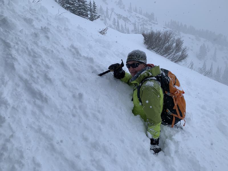
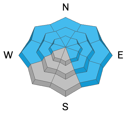
The avalanche danger is HIGH at mid and upper elevations as new snowfall and wind-drifted snow continues to add more weight on top of a buried persistent weak layer (PWL). The avalanche danger is CONSIDERABLE at elevations below 8,000'.
Step off your sled or off the skin track and take note of any wind loading, recent avalanches, cracking, collapsing, and whoomphing as these are all signs that our weak snowpack is overloaded.
Today is a day to back off of and out from under steep terrain.
Low
Moderate
Considerable
High
Extreme
Learn how to read the forecast here
Avalanche Warning
The avalanche danger for the warning area is HIGH for the mountains of northern and central Utah and southeast Idaho, which includes the Wasatch Range...the Bear River Range...Uinta Mountains...Manti-Skyline plateau...and the Mountains of Southwestern Utah.
Strong winds and heavy snowfall have created dangerous avalanche conditions. Avalanches failing on a widespread persistent weak layer buried under the new snow are likely. Stay off of and out from under slopes steeper than 30°.
This avalanche warning is in effect from Thursday, January 10, 2024 - 6:00am to Friday, January 11, 2024 - 6:00am
Special Announcements
Wondering what happened to the mid-pack PWL? Curious how the December dry spell will play out? Interested in what factors determine future stability trends? Please join UAC forecaster Craig Gordon at 6:00 on Thursday January 11th, at the Kimball Junction library for a FREE State of the Snowpack presentation. More INFO
Weather and Snow
Under partly cloudy skies, trailhead temperatures are in teens °F while the highest ridgelines are in the single digits °F. Winds have blown all night from a northwesterly direction in the teens MPH gusting to the high 20's MPH at the 9,000' ridgelines. There were reports 8-14" of snow and .5" of water in the last 24 hours. This snow has been heavily wind affected and deeper drifts can be found in exposed areas and at higher ridgelines.
For today, we are expecting temperatures 15-20°F with winds blowing from the northwest 15 gusting to 20 MPH. Snow will continue throughout the day with 1-3" of new snow expected and up to .20" of water. There could be periods of lake enhanced showers which may bring an additional 7" of low-density snow to favored areas in Ogden, particularly in the area south of I-84.

Our partners at the National Weather Service have updated the forecast and are calling for 35-50" of snow with an additional 3"-3.5" of water with a more substantial storm moving into the area Friday afternoon-Saturday.
Recent Avalanches
Yesterday, we had forecasters in the field in the Powder Mountain backcountry and on the North Ogden Divide. They reported 4 out of the 5 red flags (see video below).
There were reports of dry-loose activity where the newest storm snow was running on a density change. These dry-loose avalanches in the new snow could entrain more snow in steep long running slopes as well as be the additional weight needed to break down in the buried PWL layer triggering a much deeper avalanche. Expect to see dry-loose storm snow avalanches today.

While this report is from the Central Wasatch it is a thinner snowpack area that often resembles the snowpack found in the Ogden Area Mountains and is representative of something that could happen if someone gets into or under steeper terrain.
Photo below showing a close call with a partial burial in Mineral Fork. Thanks to the parties involved for sharing a detailed report.
Ad
Avalanche Problem #1
Wind Drifted Snow
Type
Location
Likelihood
Size
Description
You will find reactive soft slabs of wind-drifted snow at the mid and upper elevations. It won't take much wind to transport this new snow around and any additional snow and wind could be enough to tip the scales creating avalanches failing down into the buried PWL layer from the old snow surface.
New snow drifting and loading has already been extensive enough for NATURAL AVALANCHES to have occurred in steep terrain.
Avalanche Problem #2
Persistent Weak Layer
Type
Location
Likelihood
Size
Description
The December drought layer PWL of weak sugary facets has been further stressed and overloaded by blowing and drifting snow. Cracking and collapsing will be much more common today, as will both natural and human triggered avalanches.

In the video below Trent talks about the weak faceted snow with the newest snow on top and shows us what it looks like buried in the snowpack.
Additional Information
Check out a forecaster discussion Mark and I had diving deeper into the forecast and how we will travel in the backcountry with a buried PWL

Check out this video Craig Gordon put together talking about the 5 red flags we use to determine if there is unstable snow.
1. Recent Avalanches
2. Cracking and Collapsing
3. Strong Winds
4. Heavy Snowfall
5. Rapidly Rising Temperatures
General Announcements
This information does not apply to developed ski areas or highways where avalanche control is normally done. This forecast is from the U.S.D.A. Forest Service, which is solely responsible for its content. This forecast describes general avalanche conditions and local variations always occur.