

Forecast for the Moab Area Mountains

Issued by Dave Garcia on
Thursday morning, April 4, 2024
Thursday morning, April 4, 2024
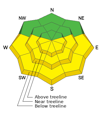
Most terrain has a LOW danger this morning. As the day heats up, avalanches involving wet snow will become possible on slopes that face E-S-W at all elevations. The danger will rise to MODERATE on these slopes by this afternoon.
Practice safe travel protocol and remember that during LOW danger small avalanches remain possible in isolated areas and extreme terrain.
Low
Moderate
Considerable
High
Extreme
Learn how to read the forecast here
 Special Announcements
Road Conditions: The lower end of the Geyser Pass road is now mostly dry dirt. Melting snow on the upper end will make for sloppy and muddy conditions later in the day.
Grooming: The trail into Gold Basin was rolled out Monday.
 Weather and Snow
6:00 a.m. Snow and Weather Data
24 Hour Snow 0" 72 Hour Snow 0" Season Total Snow 190" Depth at Gold Basin 62"
Winds on Pre-Laurel Peak: 24-27 S Temp 29° F Percent of Normal: 128%
Weather
Under clear skies this morning it is 29 degrees in Gold Basin. Winds are blowing out of the South in the mid-20's MPH. A trough and area of low pressure will reach central California this morning and start to move eastward. Flow around the low will start tapping into some Pacific moisture which will allow some high clouds to form this afternoon. Southerly winds will be on the increase and will reach speeds of 25-35 MPH by this afternoon. Today will be warmer than yesterday, with a high of around 40 degrees. Overnight, wind speeds will continue to increase. By tomorrow, Southerly winds will blow in the 50 MPH range with stronger gusts. A cold front arrives Friday night, and temperatures will crash to around 10 degrees. Snow showers begin Friday night and continue into Saturday. The storm doesn't look like a big producer, but might provide a nice refresh.
General Conditions
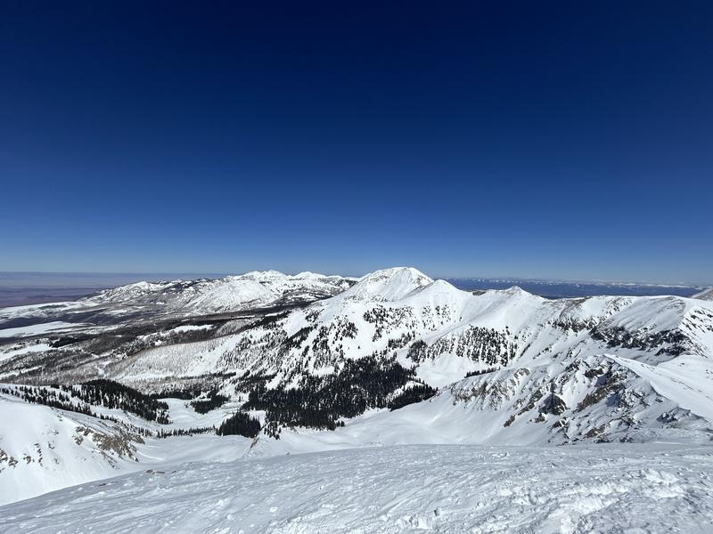
Skiing and riding conditions are still quite good on high-elevation Northerly aspects. Yesterday's calm winds and sunny skies provided a nice window for getting up high into the alpine. In our travels, we found variable snow conditions above 11,600 ft. Strong winds earlier in the week have affected the snow surface up high. You will find a mix of stiff wind crusts mixed in with some shallow, soft powder riding. Solar aspects are on the verge of an early corn cycle, and they will be frozen this morning. The sunny slopes may soften up this afternoon and offer good turns. However, strong Southerly winds might put a damper on this today. Wet avalanche activity is your number one concern for today. The mountains got a refreeze last night, but high temperatures will once again reach 40 degrees, and we will see plenty of sunshine this morning before the high clouds move in. Wet snow problems are easy to avoid, once the solar aspects become saturated, it is time to move over to Northerlies, or head home.
Snowpack and Weather Data
Gold Basin Storm Stake (10,000')
Gold Basin SNOTEL site (10,000')
Wind Station on Pre-Laurel Peak (11,400')
 Recent Avalanches
Click here to see the La Sal avalanche database. Prudent backcountry travelers will want to know what slopes have previously avalanched, as some of these slopes hold shallow, weak snow.

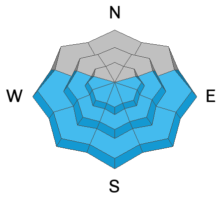
Avalanche Problem #1
Wet Snow
Type
Location
Likelihood
Size
Description
Be alert to changing conditions on solar aspects as the day heats up. These slopes will be frozen this morning. With warm temperatures in the forecast and strong April sunshine, wet-loose activity will become possible. Signs of wet activity include roller balls, pinwheels, wet, slushy snow, or your boots and skis sinking deep into the snow. When you observe these signs, it is time to head over to Northerly aspects.
Avalanche Problem #2
Normal Caution
Type
Location

Likelihood
Size
Description
Springtime in the mountains can offer a wide range of conditions. Even though most slopes offer a LOW danger, there are still a few things to watch out for today:
- In shallow snowpack areas, slabs of wind-drifted snow exist on top of weak, faceted snow. This problem is somewhat isolated and exists on some slopes that have previously avalanched. When in doubt, grab your probe to check for depth. If the snowpack is shallow, grab your shovel and look for faceted snow.
- Remember that LOW danger doesn't mean NO danger, and small avalanches in complex terrain can have very serious consequences.
- Drew Hardesty recently wrote a great blog about how we choose terrain in LOW danger, you can read it here.
Additional Information
Want some more insight into the La Sal Mountains as well as the communal impacts of a tragic avalanche? Check out the latest UAC podcast with forecaster Eric Trenbeath where he discusses the range, it's often treacherous snowpack, and how the devastating avalanche in February, 1992, affected the Moab community.
Our avalanche beacon checker sign and beacon training park are up and running. A huge thanks to Talking Mountain Yurts for sponsoring those this season!
Sign up for forecast region-specific text message alerts. You will receive messages about changing avalanche conditions, watches, warnings and road plowing closures.
Follow us on Instagram @utavy_moab
General Announcements
This forecast is from the U.S.D.A. Forest Service, which is solely responsible for its content. This forecast describes general avalanche conditions and local variations always occur.