Forecast for the Moab Area Mountains

Eric Trenbeath
Issued by Eric Trenbeath on
Thursday morning, April 3, 2025
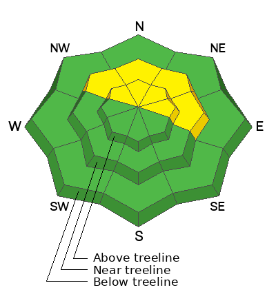
A MODERATE avalanche danger this morning could reach CONSIDERABLE later today on steep, wind drifted slopes near and above treeline that face NW-N-NE-E. Human triggered avalanches involving recent deposits of wind drifted snow are possible and could become likely. Pay attention to changing conditions and avoid steep slopes with recent deposits of wind drifted snow.
Becoming more the exception than the rule, it is still POSSIBLE to trigger a deep hard slab avalanche failing on buried persistent weak layers. This problem exists near treeline and above on slopes facing NW-N-NE-E and the danger remains MODERATE. Very steep slopes with a shallow snowpack are the most suspect areas.
Low
Moderate
Considerable
High
Extreme
Learn how to read the forecast here
Special Announcements
Construction continues on the Loop Road Mon-Fri. It will be closed near Pack Creek from 8:30-5:30.
Geyser Pass Road: Expect to find a few inches of fresh snow on Geyser Pass road. 4x4 recommended.
Grooming Conditions: Gavin groomed yesterday. Expect several inches of new snow on trails today.
Motorized Users—Please consider taking this 5-minute survey to help researchers better understand avalanche education participation and safety preparedness. Responses are anonymous and confidential. Thank you!
Weather and Snow
6 A.M. Snow and Weather Data
24 Hour Snow: 5" 72 Hour Snow: 10" Season Total Snow: 132" Depth at Gold Basin: 50"
Winds on Pre-Laurel Peak: N/A Temp: 18° F
Weather
Overnight snowfall has already exceeded expectations and more is on the way today as a closed low pressure system moves through the Four Corners. We should see snowfall off and on most of the day with another 4-8 inches possible. Southeast winds will blow in the 10-15 mph range before shifting to the southwest later today. High temperatures will be in the low to mid 20's at 10,000'. Things wind down this evening although a secondary system to the north will keep the chance for snow alive through Friday.
General Conditions
Incremental snowfall this week is slowly but surely improving conditions and today should be the best day so far. Mark White was up yesterday and he found good skiing on low angle, northerly aspects in the alpine but he also reported some recent, natural wind slab activity high up on the NE face of Tukno. Fresh drifts today will add to previously formed wind slabs and human triggered avalanches a foot or more deep will be possible. Last week's heat wave and subsequent cold snap has really locked up the snowpack, and beneath this week's fresh snowfall the surface is firm and solid. This has greatly diminished the likelihood for triggering a deep hard slab avalanche failing on a persistent weak layer but it's still not beyond the realm of possibility. Likely trigger points include steep convexities, thin slab margins, and shallow rocky areas. Sticking to broad, planar slopes will help minimize your risk.
Snowpack and Weather Data
Gold Basin SNOTEL site (10,000')
SNOTEL site near Geyser Pass Winter Trailhead (9600')
Wind Station on Pre-Laurel Peak (11,400')
NWS forecast for the La Sal Mountains.
Recent Avalanches
Mark White observed these natural wind slab avalanches yesterday.
A snowboarder triggered a large and dangerous avalanche on Horse Head Bowl in the Abajo mountains Saturday. We are extremely grateful for a positive outcome and his thorough and thoughtful report.
See the complete avalanche database here.
Ad
Avalanche Problem #1
Wind Drifted Snow
Type
Location
Likelihood
Size
Description
Fresh deposits of wind drifted snow are likely to become deeper and more widespread today on slopes facing NW-N-NE-E. One thing to keep in mind is that the more consequential the terrain, the more consequential the problem. Avoid steep, wind drifted slopes, especially in areas of consequential terrain. Wind drifts are recognizable by their smooth, round, or rippled appearance and cracking is a sign of instability.
Avalanche Problem #2
Persistent Weak Layer
Type
Location
Likelihood
Size
Description
Warm temperatures last week, percolating meltwater in the snowpack, and several nights with a solid refreeze have significantly decreased the likelihood for triggering an avalanche on a persistent weak layer. However, layers of cold, dry faceted snow still remain on steep, northerly aspects near treeline, and in some areas above. Shallower snowpack areas are where you are most likely to find trouble and any avalanche triggered would be deep and dangerous. You can pull out your probe to determine snowpack depth. If you are finding depths of a 180 cms or more, you are probably okay but remember that shallow trigger points exist.
Additional Information
Check out the latest UAC podcast with forecaster Brett "Kowboy" Kobernick where he discusses faceted persistent weak layers and how "nobody is immune from getting killed in an avalanche."
Sign up for text alerts to get the most up to date information about changing conditions, road plowing, special avalanche announcements.
Follow us on Instagram @utavy_moab
General Announcements
This forecast is from the U.S.D.A. Forest Service, which is solely responsible for its content. This forecast describes general avalanche conditions and local variations always occur.