Forecast for the Moab Area Mountains

Eric Trenbeath
Issued by Eric Trenbeath for
Sunday, April 16, 2023
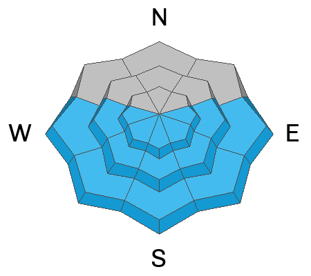
Most terrain has LOW danger. Unstable slabs of wind drifted snow may exist on isolated terrain features above treeline.

As the day heats up we'll see an increased likelihood for small loose, wet sluffs on sun exposed slopes. Avoid steep slopes when they become wet and sloppy.

Cornices are massive, give them a wide berth.
Low
Moderate
Considerable
High
Extreme
Learn how to read the forecast here
Special Announcements
Today will be our last regularly scheduled daily forecast. I will update through the month as condtions warrant.
Geyser Pass Road: The road is down to the dirt and turns muddy as the day heats up.
Grooming: Gavin pulled an all-nighter Friday, and trails are groomed for the weekend!
Weather and Snow
6:00 a.m. Snow and Weather Data
24 Hour Snow 0" 72 Hour Snow 7" Season Total Snow 322" Base Depth at Gold Basin 93"
Temp 19°F Winds on Pre-Laurel Peak: W 8-12

Weather
High pressure remains over the area today. Look for sunny skies, light SW winds, and high temps climbing up to around 40°F at 11,000'. Monday will bring more of the same with the exception of increasing SW winds. A long wave trough moving into the Pacific NW on Monday night will bring cooler temps and unsettled weather through the week although any precipitation looks to stay well to the north. Tuesday looks to be quite windy.
General Conditions
It was a busy day in the mountains yesterday with dozens of descents of the high peaks in Gold Basin and surrounding terrain. Avalanche activity was pretty much non existent with only a report or two of people encountering very small and isolated wind slabs. Loose, wet avalanche activity was also surprisingly lacking. Today will be warmer however, and loose wet sluffs on sun exposed slopes will be possible as the day heats up. These shouldn't be too problematic, but it's good policy to avoid steep slopes that have been too long under the sun this time of year.
Busy day up there yesterday! Expect more of the same today.

Snowpack and Weather Data
Gold Basin Storm Stake (10,000')
Gold Basin SNOTEL site (10,000')
SNOTEL site near Geyser Pass Winter Trailhead (9600')
Wind Station on Pre-Laurel Peak (11,400')
NWS forecast for the La Sal Mountains.
Recent Avalanches
Ad
Avalanche Problem #1
Wind Drifted Snow
Type
Location
Likelihood
Size
Description
Remain on the lookout for recent deposits of wind drifted snow on isolated terrain features above treeline that face primarily north through east. Drifts are recognizable buy their smooth, rounded appearance, and cracking is a sign of instability. Even a small triggered wind slab could carry you over a cliff, or take you for a long ride in areas of more extreme terrain.
Avalanche Problem #2
Wet Snow
Type
Location
Likelihood
Size
Description
As the day heats up the likelihood for small, loose wet sluffs will increase. These shouldn't be too problematic, but again, even a small avalanche can have devastating consequences in the wrong terrain. Rollerballs and pinwheels are signs of increasing instability. Avoid steep slopes when they get wet and sloppy.
General Announcements
This forecast is from the U.S.D.A. Forest Service, which is solely responsible for its content. This forecast describes general avalanche conditions and local variations always occur. This forecast will be updated by 7:30 tomorrow morning.