Join us at our 2nd Annual Blizzard Ball

Forecast for the Moab Area Mountains

Eric Trenbeath
Issued by Eric Trenbeath on
Thursday morning, March 4, 2021
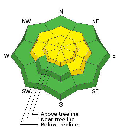
A few inches of new snow and wind have caused a slight bump in avalanche danger above treeline but the overall danger remains MODERATE. Deep and dangerous human-triggered avalanches failing on a buried persistent weak layer remain the primary concern. You are most likely to trigger one of these avalanches on steep terrain near and above treeline that faces NW through N through SE. Thin snowpack areas around rock outcroppings, sparse trees, or along slope margins are the most likely trigger points. Most S and SW facing terrain near treeline, and all low elevation terrain has generally LOW danger but you cold still trigger an avalanche in areas of more extreme terrain.
Low
Moderate
Considerable
High
Extreme
Learn how to read the forecast here
Special Announcements
The Geyser Pass Road was plowed and widened on Wednesday. There may be an inch or two of new snow on a snow-packed surface this morning. Beware of soft shoulders.
The Lower Utah Nordic Alliance (LUNA) last groomed and set classic track into Gold Basin on Monday. Expect a couple of inches of new snow today.
Weather and Snow
24 Hour Snow 3" 72 Hour Snow 3" Base Depth in Gold Basin 50" Wind S 15-25 mph Temp 20F
It's a balmy and blustery morning up there with 2"-3" of new snow. Southerly winds overnight blew in the 20-25 mph range with gusts into the 40's. Look for mostly cloudy skies today and continued breezy SW winds shifting to NW later today. High temps will be near 30F. High pressure moves in tomorrow and temps will soar into the mid 40's under sunny skies. A weak shortwave will clip by to the north on Sat night with warm and sunny skies again on Sunday. After that, all eyes are on a series of troughs and a coming unsettled weather pattern for next week. Models have yet to come up with a consistent solution.
Wind, temperature, humidity on Pre Laurel Peak (11,700')
Snotel site near Geyser Pass Trailhead (9600')
Storm totals at the Gold Basin study plot (10,000')
Snowpack Discussion
A few inches of new snow combined with wind may result in some shallow, fresh deposits of wind drifted snow at upper elevations. As always, be on the lookout for fresh drifts on the leeward sides of ridge crests and terrain features in exposed terrain. In sheltered areas, the new snow will make for a nice refresh. Warm temperatures and sun over the past two weeks have crusted over southerly aspects as well as helped strengthen and consolidate the snowpack. Near and below treeline, the snowpack is generally supportive, and you will probably not see any obvious signs of instability such as cracking or collapsing. However, if you dig down or probe the snow, you will still find weak layers near the bottom of the snowpack. The most dangerous slopes face NW-N-SE and contain a slab 1'-3' thick that is perched above weak, faceted snow. These slabs are becoming harder to trigger but once released they could produce deep and dangerous avalanches. Likely trigger points include shallower areas along slope margins, around sparse trees or rock outcroppings, or on repeat running slide paths.
Ad
Avalanche Problem #1
Persistent Weak Layer
Type
Location
Likelihood
Size
Description
Poor snowpack structure exists with consolidated slabs resting on buried persistent weak layers of loose, sugary, faceted snow on many aspects. However, the snow is getting stronger with time and relatively warm temperatures within the lower snowpack. Extended column tests were not able to produce failures that propagated across the column (ECTN28 x2). Two propagation saw tests did, however, suggest that the "propensity for propagation" is still present (PST30/100 (End) @ 32 cm and 15 cm). The most dangerous areas are on slopes above treeline that face NW-N-SE where wind drifted snow has created slabs 1'-3' deep on top of these buried weak layers. Once triggered, these slab avalanches would be large and destructive.
Avalanche Problem #2
Wind Drifted Snow
Type
Location
Likelihood
Size
Description
A few inches of new snow combined with wind will result in fresh, but shallow wind slabs at upper elevations. Look for fresh drifts on the leeward sides of ridge crests and terrain features like sub-ridges and gully walls. On steep, northerly aspects, wind drifted snow has added additional stress to buried persistent weak layers so it isn't merely a question of identifying and testing for wind slab instability. The bottom line is that steep, wind loaded, northerly-facing terrain remains very much a gamble, and deep and dangerous, human-triggered avalanches remain possible in these areas.
General Announcements
This forecast is from the U.S. Forest Service, which is solely responsible for its content. This forecast describes general avalanche conditions and local variations always occur.