Donate to the 2024 Spring Campaign to help rebuild the UAC website.

Forecast for the Moab Area Mountains

Eric Trenbeath
Issued by Eric Trenbeath for
Thursday, February 9, 2023
Strong winds have elevated the danger to MODERATE on all aspects above treeline that have recent deposits of wind drifted snow.

Near treeline and below, the danger is generally LOW but isolated slabs of wind drifted snow may still be found on specific terrain features.

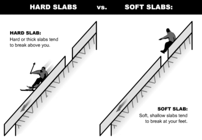
Recent slabs of wind drifted snow should be relatively shallow, but even a small avalanche can be problematic in very steep, consequential terrain.
Low
Moderate
Considerable
High
Extreme
Learn how to read the forecast here
Special Announcements
Dave and I will be at the Geyser Pass Traihead on Saturday from 9:00 - 11:00 as part of the UAC's Trailhead Avalanche Awareness Program. Stop in and say hi!
Geyser Pass Road: The road is plowed and widened with a snow packed surface.
Grooming: Trails were groomed on Monday.
Weather and Snow
24 Hour Snow T" 72 Hour Snow T" Season Total Snow 186" Base Depth at Gold Basin 69"
Winds on Pre Laurel Peak ESE 8-18 Temp 7F

Weather
The passage of last night's cold front has left us with single digit temperatures, a trace of new snow, and breezy, easterly winds. NW winds yesterday blew in the 15-25 mph range for most of the day, increasing to 30-40 mph for a few hours last night with peak gusts to 50 mph. Winds will again be on the increase today as the flow shifts to northerly. Skies will clear but temps will remain cold creeping up into the low to mid teens. High pressure and warming temperatures will be with us through the weekend, with the promise of a significant storm next Tuesday. Stay tuned.

General Conditions
As Dave noted yesterday, conditions have been deteriorating, and I'm afraid yesterday's strong, northerly winds have put the final hurt on the snow surface. Today, expect to find the full gamut of wind affected surfaces from crusted, to hard wind board, textured sastrugi, and finally, slabs of wind drifted snow. With a few inches of snow available for transport, I think we may see a little wider distribution of wind slabs up there today. Fresh drifts will be mostly shallow, and rather "pockety" in nature, meaning not wide or well connected, but you may find them in unusual places, and they may be hard or soft. South facing slopes are either firm or breakable crust.

Snowpack and Weather Data
Gold Basin Storm Stake (10,000')
Gold Basin SNOTEL site (10,000')
SNOTEL site near Geyser Pass Winter Trailhead (9600')
Wind Station on Pre-Laurel Peak (11,400')
NWS forecast for the La Sal Mountains.
Recent Avalanches
No new avalanches were reported in the backcountry. See the La Sal Avalanche database here.
Ad
Avalanche Problem #1
Wind Drifted Snow
Type
Location
Likelihood
Size
Description
With a few inches of snow available for transport, and strong northerly winds, unstable areas of wind drifted snow are back on the problem type menu. Slabs of wind drifted snow may be hard or soft and though their distribution may be fairly widespread, they are most likely "pockety" or not wide and well connected. Look for them on the leeward sides of ridge crests and terrain features such as gully walls, sub-ridges, and behind or beneath rock outcrops. Hard slabs may be difficult to identify in the mix of textured surfaces but suspect areas that sound like a drum or that feel hollow underneath.
Here is some information on hard slabs that I lifted from Drew Hardesty's Wasatch forecast this morning:
  • Hard slabs often allow one or two riders to traverse over them before the third (fourth? fifth?) rider collapses the thinner part of the teardrop, shattering it like a pane of glass
  • They commonly fracture after you're well on to the slab
  • They have a lot of spatial variability: welded in and stable here...or initially stubborn only to fracture there
  • Cracking and collapsing may not be present
  • Hard slabs may pull back onto lower angle slopes
Additional Information
General Announcements
This forecast is from the U.S.D.A. Forest Service, which is solely responsible for its content. This forecast describes general avalanche conditions and local variations always occur. This forecast will be updated by 7:30 tomorrow morning.