Forecast for the Moab Area Mountains

Nikki Champion
Issued by Nikki Champion for
Sunday, February 5, 2023
The snowpack is generally stable and the avalanche danger is LOW. The primary concerns are isolated pockets of wind-drifted snow in exposed terrain above treeline, and sluffing in the snow at the surface in steep northerly terrain.
Evaluate each slope and look for any signs of instability such as cracking in fresh wind drifts or loose surface snow easily moving.
Risk is inherent in mountain travel; even a small avalanche can be problematic in very steep and complicated terrain. Think about the terrain you are traveling above today.
Low
Moderate
Considerable
High
Extreme
Learn how to read the forecast here
Special Announcements
Geyser Pass Road: The road is open!
Grooming: All trails have not been groomed since Wednesday, and are getting a bit worn.
A huge shout out to the Grand County Winter Rescue Team for keeping up on their rescue training here in the La Sals. We know we can count on you!
Weather and Snow
24 Hour Snow 0" 72 Hour Snow 0" Season Total Snow 183" Base Depth at Gold Basin 72"
Winds on Pre Laurel Peak S 20-30 mph Temp 20 F

Weather
Today will remain sunny throughout the day as another system begins to push its way through the area. The south, southwesterly winds will remain elevated with gusts up to 30 mph. Temperatures will be near 30 F at 10,000'. Light precipitation may begin to fall after 5 PM, with the bulk of the storm arriving between 11 PM - 1 AM. Overnight 3-5" of new snow could fall.
The snow showers will linger through Monday morning, before pushing out and becoming mostly sunny by the afternoon. Winds will remain elevated, with gusts up to 25 mph. Watch for drifting snow throughout the day tomorrow. The remainder of the week looks to transition to high pressure, with mostly sunny days on the horizon.

General Conditions
We have found mostly stable conditions and soft snow on northerly aspects, even in wind-affected terrain above the treeline. While we noted texture from the wind on the snow surface, we were unable to get any slabs of wind-drifted snow to move. In the highest reaches and extreme terrain, isolated slabs of wind-drifted snow may still exist that could be sensitive to the weight of a skier or rider. We did get a bit of sluffing in steep, northerly-facing terrain, it was shallow but worth noting when traveling above consequential terrain. Even a small amount of sluff can be enough to knock a rider off their feet.
With elevated winds, and a few inches of snow in the forecast conditions could change overnight. Pay attention to the timing of the storm, if the snowfall comes in earlier than expected avalanche danger could rise this afternoon.
Multiple days of intense sun and warmer temperatures heated solar aspects and will be mostly crusted over today.
See a list of La Sal's observations here.

Snowpack and Weather Data
Gold Basin Storm Stake (10,000')
Gold Basin SNOTEL site (10,000')
SNOTEL site near Geyser Pass Winter Trailhead (9600')
Wind Station on Pre-Laurel Peak (11,400')
NWS forecast for the La Sal Mountains.
Recent Avalanches
No new avalanches were reported in the backcountry. See the La Sal Avalanche database here.
Ad
Avalanche Problem #1
Normal Caution
Type
Location
Likelihood
Size
Description
The snowpack is generally stable and natural and human-triggered avalanches are unlikely. LOW avalanche danger does not mean NO avalanche danger. In isolated areas, you may encounter:
  • Overall, the slabs of wind-drifted snow that formed during the last windy period have mostly stabilized but there may still be a few drifts out there that remain sensitive to the weight of a skier or rider. With a bump in winds today into tomorrow, pay attention to any signs of drifting snow. These potentially unstable drifts are most prevalent on steep, northerly-facing slopes above the treeline. They will be the most problematic in areas of consequential terrain where you could be swept into rocks or carried over a cliff.
  • Small sluffs within the snow surface, or directly below a shallow wind skin on steep slopes on shady aspects. Think about the type of terrain you are traveling above, and where a skier or rider could end up if knocked off their feet. In confined and sustained terrain features, sluffs can pile up deeply, especially in terrain traps.
  • While the likelihood of triggering an avalanche on the buried persistent weak layer that formed in November has become so low that we have removed that problem from our forecast. A remote possibility exits however in thinner snowpack areas, or in very steep, rocky, radical terrain.
Always practice safe travel techniques regardless of conditions. Continue to evaluate the snowpack and gather as much information as possible. Use test slopes that are representative of the terrain you wish to ski.
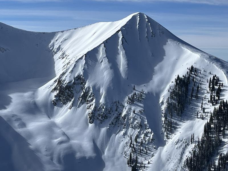
This is an example of the type of steep, wind drifted terrain you should still pay attention to. Note the areas of wind drifted snow hanging above consequential terrain.
Additional Information
General Announcements
This forecast is from the U.S.D.A. Forest Service, which is solely responsible for its content. This forecast describes general avalanche conditions and local variations always occur. This forecast will be updated by 7:30 tomorrow morning.