Fall Auction is now live! Check it out now

Forecast for the Moab Area Mountains

Eric Trenbeath
Issued by Eric Trenbeath on
Tuesday morning, February 22, 2022
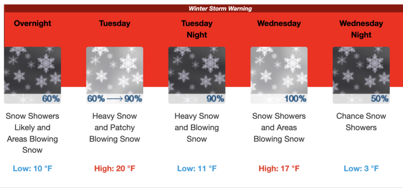
Heads up, increasing avalanche danger over the next 24 hours!
The avalanche danger is MODERATE this morning but could reach CONSIDERABLE later today. New and wind drifted snow is beginning to pile up on a variety of old and weak snow surfaces. Backcountry travelers need to be alert to changing conditions today. Be suspicious of steep slopes that have more than about 6" of new snow and avoid steep slopes with fresh deposits of wind drifted snow.
Low
Moderate
Considerable
High
Extreme
Learn how to read the forecast here
Special Announcements
Road Conditions: Expect a couple inches of snow on the road today. AWD and good tires recommended.
Grooming: Expect a few inches of new snow on the trails today.
Weather and Snow
6:00 a.m. weather data:
24 Hour Snow 5" 72 Hour Snow 5" Base Depth at Gold Basin 42" Wind SW 15-25 G35 Temp 15F
The mountains picked up 3"-5" last night with perhaps an inch or two more up high. SE winds yesterday blew in the 25-30 mph range with gusts of 35-40. They shifted to the WSW around 7:00 p.m. and backed off slightly after midnight. Today we'll see a lull in the action before the next, deeper low pressure system dives south over Nevada and then Utah later today. We should see continued off and on snow showers today with 3"-5" inches possible. The real action kicks in overnight with up to a foot of new snow when it's all said and done by Wed.
NWS Weather Forecast for the La Sal Mountains
Gold Basin SNOTEL site (10,000')
Storm Totals in Gold Basin
Wind Station on Pre Laurel Peak (11,700')
Snowpack
New and wind drifted snow has begun to pile up on the old, tired and worn, and in many cases, faceted snow surface. With so many varying surfaces out there it's difficult to know where all the problems lie but it's safe to say we are going to see an increasing avalanche danger over the next 24 hours. We should initially see some loose, dry avalanches and shallow, sensitive soft slabs within the new as it slides off of either slick and hard, or weak and faceted surfaces in the high country. In sheltered areas, human triggered new snow sluffs are likely to step down into the weak, faceted snow that exists near and below the old snow surface. In exposed terrain, blowing and drifting snow is forming unstable wind slabs on the leeward sides of ridge crests and terrain features. Expect drifts to become deeper and more widespread over the next 24 hours. And finally, as new snow piles up and starts to form a slab over the weak, faceted snow, we are going to see a new persistent weak layer problem. Conditions are changing and we are going to have to be on our toes for awhile.
Ad
Avalanche Problem #1
Wind Drifted Snow
Type
Location
Likelihood
Size
Description
Sensitive shallow wind drifts are beginning to develop along the leeward sides of ridge crests and terrain features, primarily in upper elevation, wind exposed terrain. Unstable drifts will become deeper and more widespread over the next 24 hours. Recent wind drifts are recognizable by their smooth, rounded appearance and cracking is a sign of instability. Avoid steep slopes that have recent deposits of wind drifted snow.
Avalanche Problem #2
New Snow
Type
Location
Likelihood
Size
Description
As snow accumulates over the next 24 hours, human triggered avalanches within the new snow will become increasingly more likely. These will come in the form of either loose snow or sensitive soft slabs. We will also likely see some shallow, natural releases off some of the steep, high faces. Use test slopes to see how the new snow is reacting. In sheltered areas, where the underlying snow is heavily faceted, loose snow sluffs will gouge into the old sugary snow underneath. Suspect steep slopes that have more than about 8" of new snow, and practice sluff management techniques by moving out of the fall line if the snow starts moving.
General Announcements
Who's up for some free avalanche training? Get a refresher, become better prepared for an upcoming avalanche class, or just boost your skills. Go to https://learn.kbyg.org/ and scroll down to Step 2 for a series of interactive online avalanche courses produced by the UAC.
This forecast is from the U.S. Forest Service, which is solely responsible for its content. This forecast describes general avalanche conditions and local variations always occur.