Join us at our 2nd Annual Blizzard Ball

Forecast for the Moab Area Mountains

Eric Trenbeath
Issued by Eric Trenbeath on
Saturday morning, November 6, 2021
Conditions are generally too thin for over snow travel. On isolated, northerly aspects in the high country enough snow exists to make human triggered avalanches possible. A triggered avalanche would likely be small but it could potentially knock you down and send you crashing into rocks. If you find yourself in the high country, avoid steep, wind drifted slopes and look for signs of instability such as cracking in the snow surface. This forecast will be updated as conditons warrant.
Low
Moderate
Considerable
High
Extreme
Learn how to read the forecast here
Special Announcements
The 14th Annual Utah Snow and Avalanche Workshop is virtual again this year and will be held Nov 9th, 10th, 11th evenings from 6-9pm. More info and speaker lineup on our Events page HERE.
Check all the upcoming education HERE.
Weather and Snow
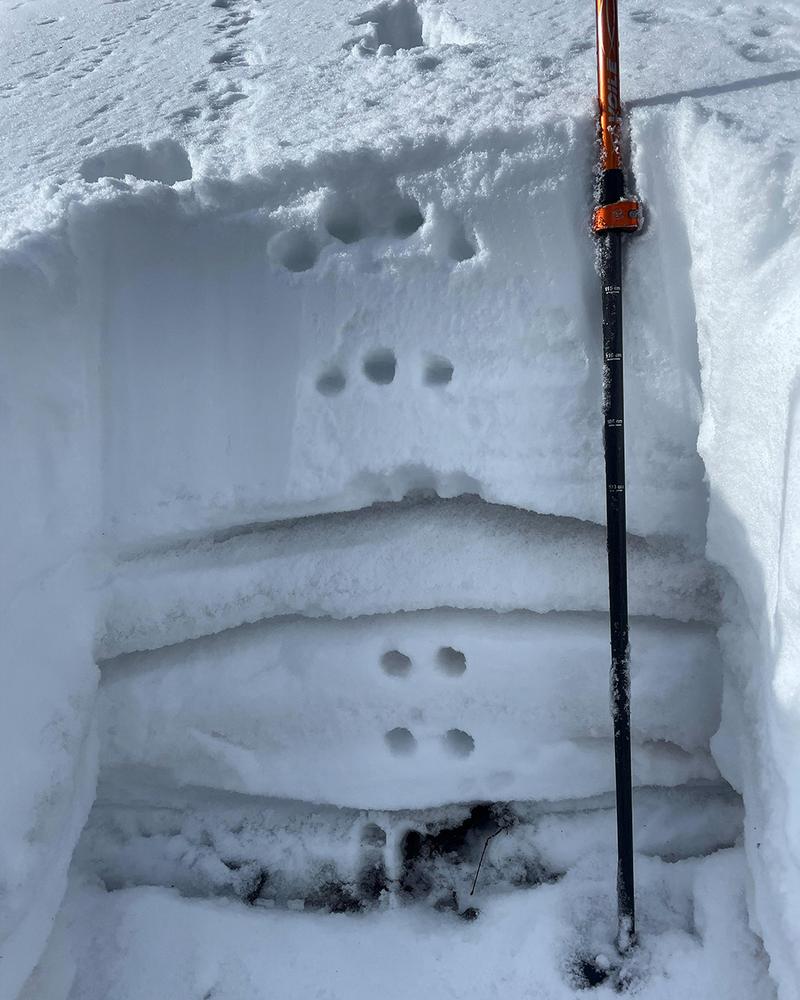
After a moist October, which saw more than 2’ of snow fall in the mountains, mostly dry conditions have set in taking a toll on our early season snowpack. Snow on northerly aspects ranges from about 6” at 10,000’ to 18” at upper elevations. Most sun exposed slopes have melted back to the ground. A few folks were able to eek out some early season turns last month, but for now conditions are generally too thin for over snow travel. And, as expected, this dry period has had a negative impact on snowpack structure. A classic La Sal set up with weak, sugary, faceted snow above and below a crust is developing. This will undoubtedly plague us as a basal weak layer in the months ahead.
Photo illustrates crust with faceted weak layers above and below.
Long range models aren't offering much hope at this time but we'll see a chance of precipitation Tuesday into Wednesday. Use the weather links below to stay abreast of current conditions.
BRAND NEW! Gold Basin SNOTEL site (10,000')
La Sal Mountain SNOTEL site (9600') near the Geyser Pass Trailhead.
Ad
Avalanche Problem #1
Normal Caution
Type
Location
Likelihood
Size
Description
General Early Season Avalanche Safety
Most avalanches happen during or right after a snowstorm. However, any time new snow falls and the wind moves it through the terrain, avalanches are possible. New snow often has a hard time adhering to hard, icy old snow surfaces, so a fall snowstorm can produce small avalanches if it falls onto old snow, grassy areas or rock slabs. The best way to manage these avalanches in the fall is to have a current weather forecast, recognize when there is enough snow to produce avalanches, and select terrain that minimizes your exposure to the risk.
New Snow Avalanches can release as either a soft cohesive layer (slab), or as loose, dry sluffs that start at a point and fan out as they entrain more snow. Loose, dry avalanches are generally harmless but they could carry you over rocks or cliffs if enough snow is involved. Soft slabs in the new snow are more dangerous. They often form when new snow falls with light winds or in wind-sheltered areas. Instability typically last for a few days. You can reduce your risk from Storm Slabs by waiting a day or two after a storm before venturing into steep terrain. Storm slabs are most dangerous on slopes with terrain traps like gullies or cliffs, or slopes that end in timber or scree fields.
Wind Drifted Snow avalanches are caused by slabs that form when wind transports snow from the windward sides of terrain features and deposits it on the leeward side. Wind drifted snow often appears smooth and rounded, and sometimes sounds hollow. Wind drifts form in specific areas leeward of terrain features. You can reduce your risk from wind slab avalanches by sticking to wind-sheltered or wind-scoured areas and avoiding drifted slopes.
General Announcements
This forecast is from the U.S. Forest Service, which is solely responsible for its content. This forecast describes general avalanche conditions and local variations always occur.