Forecast for the Moab Area Mountains

Eric Trenbeath
Issued by Eric Trenbeath on
Monday morning, January 4, 2021
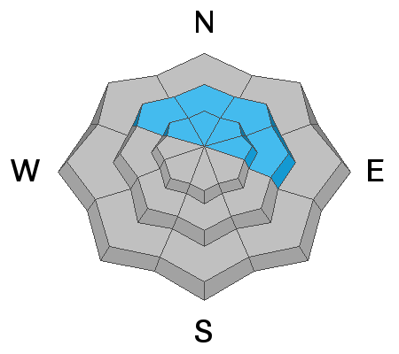
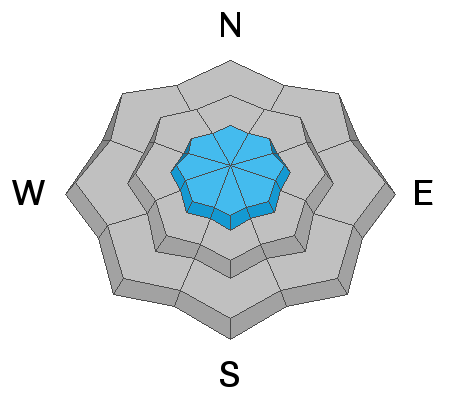
The avalanche danger remains CONSIDERABLE on steep, northerly facing slopes at mid and upper elevations. In these areas, slabs have formed on top of layers of weak, sugary, faceted snow. This persistent weak layer problem will be with us for the foreseeable future and though overall low coverage makes it difficult to access these areas, steep, northerly facing slopes should be avoided. There is an isolated or MODERATE avalanche danger on steep slopes at upper elevations that have recent deposits of wind drifted snow. Most other terrain has generally LOW danger.
Low
Moderate
Considerable
High
Extreme
Learn how to read the forecast here
Special Announcements
The Geyser Pass Road is plowed. The surface is snow packed on dirt.
The Lower Utah Nordic Alliance (LUNA) groomed last Friday.
The Utah Avalanche Center podcast's second episode of season 4 is live - Managing Risk with Avalanches, Managing Risk with a Pandemic - A Conversation with state epidemiologist Dr. Angela Dunn.
Stream here or tune in wherever you get your favorite podcasts
There are several new blogs that have recently been published:
Read a few short anecdotes in a blog from UAC staff about how avalanches can surprise us.
UAC forecasters Paige Pagnucco and Greg Gagne discussing danger ratings and persistent weak layers.
Weather and Snow
24 Hour Snow 0" 72 Hour Snow 0" Base Depth in Gold Basin 27" Wind N 5-10 Temp 16F
Although an active weather pattern will bring a series of storms to the north throughout the upcoming week, the desert southwest, and particularly our mountain range will remain dry. Long-range models however are now hinting at developing moisture early next week. Look for mostly sunny skies today with light northwesterly winds shifting to the SW later today. High temps will be in the upper 20's.
Storm totals at the Gold Basin study plot (10,000')
Wind, temperature, humidity on Pre Laurel Peak (11,700')
Snotel site near Geyser Pass Trailhead (9600')
NWS weather forecast
Snowpack Discussion Last week's snow load has added significant stress to our fragile snowpack, and in our travels over the weekend we continued to observe fairly widespread collapsing and whumphing, sure red flag signs of instability. On northerly aspects, layers of weak, sugary, faceted snow exist on top of a slick, hard melt-freeze layer forming a persistent weak layer that is bound to stick with us for some time. The snow quality below treeline is quite good, but overall coverage is still very thin so keep your enthusiasm in check and stick to low-angle grassy slopes and meadows.
Recent Avalanches
Here is a list of observed avalanches in Gold Basin from last week's storm.
Ad
Avalanche Problem #1
Persistent Weak Layer
Type
Location
Likelihood
Size
Description
A significant load has been added to our fragile snowpack. On mid and upper elevation northerly aspects, the snowpack has deteriorated into layers of weak, sugary, faceted snow on top of a slick, hard bed surface. This has created a persistent weak layer problem that will stick with us for some time. Although avalanche terrain remains difficult to access due to low coverage, human-triggered avalanches are likely in these areas and steep, northerly facing terrain will remain off-limits for the foreseeable future.
Avalanche Problem #2
Wind Drifted Snow
Type
Location
Likelihood
Size
Description
Moderate WNW winds have blown and drifted snow at upper elevations over the past couple of days. Look for unstable areas of wind drifted snow on the leeward sides of ridge crests and terrain features in exposed, upper elevation terrain. Wind drifts are recognizable by their smooth rounded appearance and cracking is a sign of instability. In most cases, a triggered wind drift will likely step down into a persistent weak layer of sugary, faceted snow causing a deeper, and more dangerous avalanche. Avoid steep slopes with areas of wind drifted snow.
General Announcements
This forecast is from the U.S. Forest Service, which is solely responsible for its content. This forecast describes general avalanche conditions and local variations always occur.