AVALANCHE WARNING!! Tap for info
UDOT PLANNED AVALANCHE CLOSURES!!

Forecast for the Moab Area Mountains

Eric Trenbeath
Issued by Eric Trenbeath on
Thursday morning, January 30, 2025
The overall danger is LOW and generally safe avalanche conditions exist. Watch for unstable snow in outlying areas. Human-triggered avalanches are unlikely, but small avalanches remain possible in isolated areas or extreme terrain. Steep northerly facing slopes carry the highest risk.
Low
Moderate
Considerable
High
Extreme
Learn how to read the forecast here
Special Announcements
Urgent battery replacement required for anyone who received batteries from one of our participating "Batteries for Beacons" shops. Please review the "Batteries for Beacons" replacement notice on our blog. Batteries distributed through our "Batteries for Beacons" program this year have shown to be inadequate length.
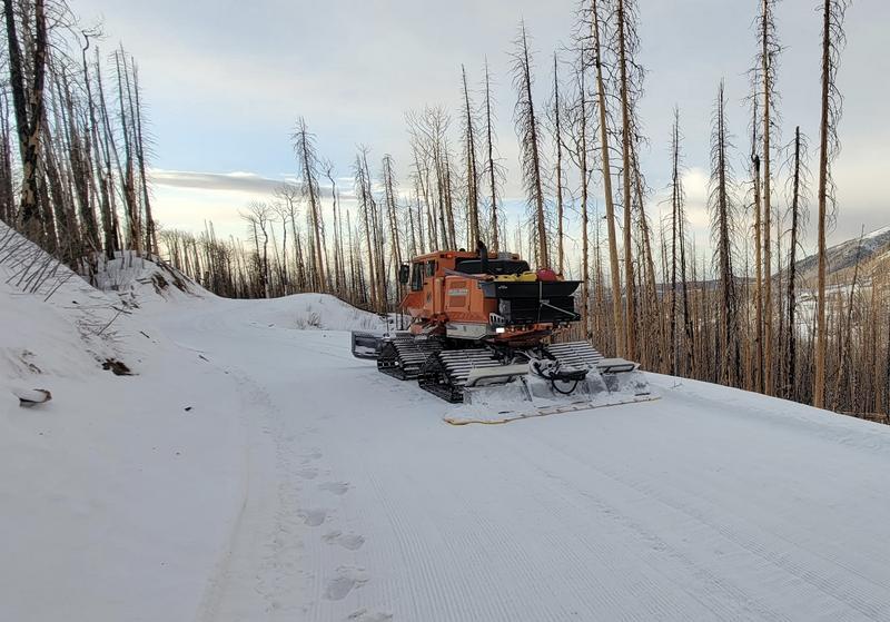
Geyser Pass Road: Surface is mainly snowpacked and icy above and bare dirt down low. AWD with good tires recommended.
Grooming Conditions: Gavin and Sam Van Wetter teamed up and groomed all trails yesterday! Thanks guys!
Weather and Snow
6 A.M. Snow and Weather Data
24 Hour Snow: 0" 72 Hour Snow: 0" Season Total Snow: 63" Depth at Gold Basin: 29"
Winds on Pre-Laurel Peak: N 15-20 G 34 Temp: 27° F Percent of Normal (SWE): 72%
Weather
The closed low has moved on to the east without bringing us any snow. As a parting shot, north winds picked up around midnight blowing in the 15-20 mph range with gusts into the 30's. They'll continue to blow today, especially up high. Skies will be clear and high temperatures at 10,000' will be in the mid to upper 20's. Temperatures will increase each day with the potential for record highs from Sunday to Tuesday. The weekend will also see some cloudiness as a result of an atmospheric river event slated to impact the Wasatch Mountains to the north. There are no storms on the horizon for us at this time.
General Conditions
What to say that hasn't already been said. Check out this observation from Ryan Huels who was up in the high country yesterday. He sums it up well, and he did observe some collpasing of isolated wind drifts near treeline. Above treeline the surface is very hard and wind blasted or scoured down to the rocks. Near treeline and below is a mix of variable, and somewhat grabby conditions. The overall snowpack is weak in many places, especially on shady slopes below treeline where small, loose dry avalanches are possible on very steep slopes. I searched the archives for the last time conditions were this grim on this date and it turns out we had even less snow on Jan 30, 2018. Base depth in Gold Basin was 25 inches.
First we were too far south, then we were too far north! I'm glad to hear areas south of us finally received something however. Arizona Snowbowl outside of Flagstaff picked up 9 inches bringing their season total to a mere 38 inches.
Snowpack and Weather Data
Gold Basin SNOTEL site (10,000')
SNOTEL site near Geyser Pass Winter Trailhead (9600')
Wind Station on Pre-Laurel Peak (11,400')
NWS forecast for the La Sal Mountains.
Recent Avalanches
Ad
Avalanche Problem #1
Normal Caution
Type
Location
Likelihood
Size
Description
The avalanche danger is low and conditions are generally stable. Here are a few things to keep in mind as you travel through the backcountry today.
  • Persistent Weak Layer - Our snowpack is generally weak and faceted in many areas. This is different than your typical late-season low danger. If you are getting into big lines and steep terrain, it is always wise to evaluate the snowpack first. Look for slabs over weak layers. Reduce your risk by avoiding likely trigger points like shallow rocky areas, steep convexities, and thin slab margins.
  • Wind Drifted Snow - The La Sals are a high, islolated, wind swept mountain range and snow is often transported and then deposited as slabs of wind drifted snow. The current threat is isolated to specific terrain features and avalanches will be small, but they could sweep you off your feet and carry you over a cliff in the wrong location. Remain cautious of smooth, rounded, hollow feeling, areas, especially when in consequential terrain.
  • Loose Dry Avalanches - Below treeline on northerly aspects, the snowpack is entirely loose and faceted. You can trigger small dry-loose avalanches in very steep terrain. These slides would not be large enough to bury you, but they could sweep you off your feet and carry you into a tree or over a cliff.
Additional Information
Sign up for text alerts to get the most up to date information about changing conditions, road plowing, special avalanche announcements.
Follow us on Instagram @utavy_moab
General Announcements
This forecast is from the U.S.D.A. Forest Service, which is solely responsible for its content. This forecast describes general avalanche conditions and local variations always occur.