Forecast for the Moab Area Mountains

Eric Trenbeath
Issued by Eric Trenbeath for
Friday, January 26, 2024
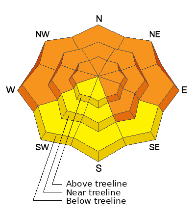
A CONSIDERABLE avalanche danger remains on steep slopes facing W-N-E-SE. Human triggered avalanches failing on a buried persistent weak layer 2' deep or more are LIKELY. On steep, wind loaded, northerly aspects near treeline and above, avalanches could break up to 6' deep.
A MODERATE avalanche danger exists on steep slopes facing SW-S. Signs of instability will be less obvious on these aspects, but human-triggered avalanches failing on a buried persistent weak layer remain POSSIBLE.

This persistent weak layer problem will be with us for some time. Exercise patience and avoid slopes steeper than 30 degrees.
Low
Moderate
Considerable
High
Extreme
Learn how to read the forecast here
Special Announcements
Road Conditions: Crews will be plowing the Loop Road but they have no plans for Geyser today. Expect a few inches of new snow on the road. AWD with good tires recommended.
Grooming: LUNA will be up grooming today.
Our avalanche beacon checker sign and beacon training park are up and running. A huge thanks to Talking Mountain Yurts for sponsoring those this season!
Weather and Snow
6:00 a.m. Snow and Weather Data
24 Hour Snow 4" 72 Hour Snow 6" Season Total Snow 95" Base Depth at Gold Basin 44"
Winds on Pre-Laurel Peak: NW 10-15 G 25 Temp 22˚ F

Weather
That was a bit underwhelming. The storm has moved on leaving about 4" of snow in the mountains, the last we'll see for awhile as high pressure builds over the region. Today, look for sunny skies, breezy NW winds, and high temps in the upper 20's. Dry, sunny, and warmer conditions will continue for the next several days. Don't abandon all hope however, things to look to get more active again late next week so enjoy the sunshine and warmer temperatures while we have them.
General Conditions
Yet another refresh should make for good turning and riding conditions up there today. The fly in the ointment will be the pesky NW winds. They shouldn't be too out of hand but they'll likely affect the snow surface on more exposed slopes. The snowpack is starting to feel supportive which has really helped riding conditions, but step off your skis or sled, and you still punch through almost to the ground, especially on northerly aspects. What this means is that a cohesive slab exists on top of very weak, faceted snow underneath. Throughout our travels this week, Dave and I continued to experience collapsing of the snowpack on a variety of aspects and elevations. This indicates that the poor structure is widespread, and that it remains sensitive to the weight of a skier or rider. Human triggered avalanches up to 2' deep are likely on steep slopes facing W-N-E-SE. On steep, wind loaded, northerly aspects dangerous, unsurvivable avalanches up to 6' deep are possible.
Check out the video below Dave made of his tour on Tuesday up Noriega's Ridge where he continued to find very weak snow.
Snowpack and Weather Data
Gold Basin Storm Stake (10,000')
Gold Basin SNOTEL site (10,000')
SNOTEL site near Geyser Pass Winter Trailhead (9600')
Wind Station on Pre-Laurel Peak (11,400')
NWS forecast for the La Sal Mountains.
Ad
Avalanche Problem #1
Persistent Weak Layer
Type
Location
Likelihood
Size
Description
Incremental loading continues to stress the persistent weak layer in our snowpack keeping us in a perpetually dangerous state. Collapsing continues to be widespread on a variety of aspects and elevations. The suspect weak layer is buried about 2 feet below the snow surface, and is easily observed in snow pits. Human triggered avalanches up to 2 feet deep remain likely. Above treeline, leeward slopes hold deep hard slabs of previously wind-drifted snow and dangerous avalanches can break 2-6 feet deep.
The persistent weak layer problem is not limited to the shady slopes. Southerly aspects have poor snowpack structure and yesterday, Dave and I got very reactive test results on a SE aspect at 11,000' (see video below). The strategy continues to be avoidance of slopes steeper than 30 degrees on all aspects.
Additional Information
Want some more insight into the La Sal Mountains as well as the communal impacts of a tragic avalanche? Check out the latest UAC podcast with forecaster Eric Trenbeath where he discusses the range, it's often treacherous snowpack, and how the devastating avalanche in February, 1992, affected the Moab community.
Sign up for forecast region-specific text message alerts. You will receive messages about changing avalanche conditions, watches, warnings and road plowing closures.
Follow us on Instagram @utavy_moab
General Announcements
This forecast is from the U.S.D.A. Forest Service, which is solely responsible for its content. This forecast describes general avalanche conditions and local variations always occur.